Tuvuca

Tuvuca
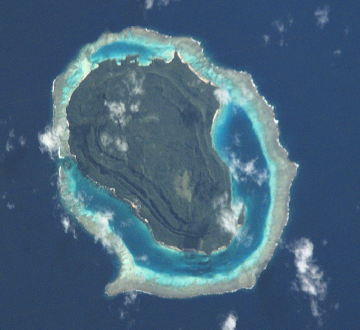
Tuvuca
ISS-Bild von Tuvuca
ISS-Bild von Tuvuca
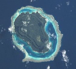
Gewässer Pazifischer Ozean
Inselgruppe Lau-Inseln
Geographische Lage 17° 40′ 27″ S, 178° 49′ 8″ W-17.674166666667-178.81888888889244Koordinaten: 17° 40′ 27″ S, 178° 49′ 8″ W
Tuvuca (Fidschi)
Tuvuca
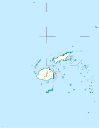
Länge 5,7 km
Breite 3,4 km
Fläche ca. 12 km²dep1
Höchste Erhebung 244 m
Hauptort Tuvuca

Tuvuca [tuˈβuða], auch Tuvutha,[Anmerkung 1] ist eine Insel vulkanischen Ursprungs im Norden des Lau-Archipels im Pazifischen Ozean. Politisch gehört sie zur Eastern Division des Inselstaates Fidschi.

Geographie

Tuvuca liegt rund 50 km nördlich von Lakeba, der Hauptinsel des Archipels, 35 km südwestlich von Mago, 35 km nordöstlich von Nayau sowie 45 km östlich von Cicia. Benachbarte Inseln sind die deutlich kleineren Eilande Vekai, 9 km nördlich, sowie Yaroua, 15 km südöstlich gelegen. Tuvuca hat eine Länge von 5,7 km, eine Breite von bis zu 3,4 km und weist eine Fläche von etwa 12 km² auf. Die Insel ist vollständig von einem Korallenriff mit einer schmalen Lagune umsäumt und erreicht im tafelbergartigen Inneren eine Höhe von 244 m über dem Meer.[1] Die Insel ist bewohnt, die einzige Siedlung Tuvuca (Tuvutha)[2] liegt an der Südwestküste.

Anmerkungen

  1. In Fidschi wird das "c" als "th" (wie im englisch "this") ausgesprochen, so dass auch diese Schreibweise oft auf Karten und in der Literatur zu finden ist

Einzelnachweise

  1. Sailing Directions (enroute), Pub. 126, Pacific Ocean (PDF; englisch)
  2. Eintrag bei geonames.org (englisch)

Wikimedia Foundation.

Игры ⚽ Нужна курсовая?

Schlagen Sie auch in anderen Wörterbüchern nach:

  • Tuvuca — (pronounced|tuβuða) is a small island off Vanua Balavu in Fiji s Lau archipelago, it is a densely wooded and inhabited island and rises 800 feet above sea level at the highest point,It has only one village on the Island. Tuvuca has untaped… …   Wikipedia

  • Lomaloma — is a village on the Fiji island of Vanua Balavu in the Lau archipelago. It is part of the Tikina (tribal district) of Lomaloma which comprises 9 villages, which is further made up of 13 Yavusa (tribes) which are further broken down into 42… …   Wikipedia

  • List of Fiji-related articles — NOTOC Articles (arranged alphabetically) about people, places, things, and concepts related to or originating from Fiji, include: 0 9 2007 Colonial Cup A Rodney ACRAMAN Adi Adi Da James AH KOY Air Fiji Air Pacific Air Pacific destinations Ahmed… …   Wikipedia

  • Mago Island — Coordinates: 17°26′S 179°09′W / 17.433°S 179.15°W / 17.433; 179.15 …   Wikipedia

  • Eastern Division, Fiji — The Eastern Division of Fiji is one of Fiji s four divisions. It consists of the four provinces, Kadavu, Lau, Lomaiviti and Rotuma.The capital of the division is Levuka, on the Ovalau island. Other islands in the division include Kadavu, Gau,… …   Wikipedia

  • Lau Islands — The Lau Islands (also called the Lau Group, the Eastern Group, the Eastern Archipelago) of Fiji are situated in the southern Pacific Ocean, just east of the Koro Sea. Of this chain of about one hundred islands and islets, about thirty are… …   Wikipedia

  • Cicia —   Island   …   Wikipedia

  • Ogea Levu — (pronounced [oˈŋea ˈleβu]) is a coral island on a barrier reef in Fiji s Southern Lau archipelago. With an area of 13.3 square kilometers, it is situated at 19.18° South and 178.47° East, 10 kilometers east of Fulaga. It has a maximum altitude of …   Wikipedia

  • Ogea Driki — (pronounced [oˈŋea ˈndriki]) is a coral atoll (covering approximately 4 square kilometers) in Fiji s Southern Lau Group. It 2.7 kilometers south from Ogea Levu, 10 kilometers east of Fulaga. It is the farming and fishing ground for the Ogean… …   Wikipedia

  • Ono-i-Lau — NASA picture of Ono i Lau. Ono i Lau is a volcanic and coral island in Fiji s Lau archipelago. One of the southernmost of the Lau Islands, it is located at 20.80° South and 178.75° East, and occupies an area of 7.9 square kilometers. It has a… …   Wikipedia

Share the article and excerpts

Direct link
Do a right-click on the link above
and select “Copy Link”