- Washington State Route 16
-

Karte 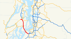
Basisdaten Gesamtlänge: 43.47 km 27.01 Meilen Eröffnung: 1964 Anfangspunkt:  I-5 Interstate 5 Tacoma
Endpunkt:  WA 3Washington State Route 3 Gorst
Countys: Pierce County
Kitsap CountyWichtige Städte: Tacoma
Gig Harbor
Port OrchardState Route 16, allgemein Highway 16 genannt, ist ein 43.47 km langer Freeway im US-Bundesstaat Washington, der den Interstate 5 und State Route 3 verbindet.
Inhaltsverzeichnis
Streckenbeschreibung
Die State Route 16 startet an der Interstate 5 in Tacoma (Ausfahrt 132, genannt Nalley Valley Interchange), führt von dort in nördlicher Richtung und überquert bei Meilenstein 5.62 die Tacoma Narrows Bridge auf die Gig Harbor Peninsula. Von Interstate 5 bis zur Ausfahrt Gig Harbor Olympic Drive Northwest bietet SR 16 eine High-occupancy vehicle lane in beide Fahrtrichtungen. Der Abschnitt zwischen der Ausfahrt Union Avenue und Interstate 5 befindet sich zur Zeit im Ausbau.[1] Von Gig Harbor verläuft SR16 weiter in Richtung Burley, Bethel und Port Orchard. Der Endpunkt von SR16 ist in Gorst, wo SR 16 und Washington State Route 3 zusammentreffen.
Autobahnzubringer
Der 0.63 km (0.39 Meilen) lange Autobahnzubringer State Route 16 Spur verbindet Washington State Route 3 und State Route 16.
Liste der Ausfahrten und Meilensteine
County Ort Meilenstein[2] Ausfahrt Richtungen Anmerkungen Pierce Tacoma 0.00 Autobahnkreuz Interstate 5 Seattle, Portland 0.38 Sprague Avenue 1.14 1B Union Avenue 1.95 1C Center Street – Fircrest 2.51 2 South 19th Street, Orchard Street 2A (West) und 2B (Ost) 3.63 3 Anschlussstelle Richtung State Route 163 6th Avenue und Ruston 4.67 4 Jackson Avenue, 6th Avenue – University Place 5.62 Tacoma Narrows Bridge 6.54 8 Point Fosdick, Wollochet Mautpflichtig in Richtung Tacoma 7.74 9 36th Street Northwest – Tacoma Narrows Airport Gig Harbor 8.51 10 Olympic Drive Northwest 9.78 Wollochet Drive Northwest – Gig Harbor City Center 12.63 Burnham Drive Northwest 13.52 Key Center, Purdy 15.81 Shelton, Key Center, Purdy Kitsap 17.88 20 Burley-Olalla Road 20.38 Mullenix Road Port Orchard 22.91 Sedgwick Road – Southworth Ferry 24.46 Old Clifton Road, Tremont Street – Port Orchard 25.63 Port Orchard Westliches Ende von SR 16 Gorst 26.67 State Route 3, Belfair, Shelton 27.01 State Route 3, Bremerton,Poulsbo Einzelnachweise
- ↑ http://www.wsdot.wa.gov/Projects/PierceCountyHOV/SR16_WBNalleyValley/ WSDOT Project SR 16 Nalley Valley
- ↑ Washington State Department of Transportation, State Highway Log, 2006
Kategorie:- Washington State Route


Wikimedia Foundation.