Deatsville

Deatsville
Deatsville
Elmore County Alabama Incorporated and Unincorporated areas Deatsville Highlighted.svg
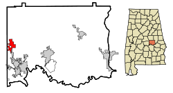
Lage im County und in Alabama
Basisdaten
Staat: Vereinigte Staaten
Bundesstaat: Alabama
County:

Elmore County

Koordinaten: 32° 36′ N, 86° 24′ W32.608333333333-86.39472222222295Koordinaten: 32° 36′ N, 86° 24′ W
Zeitzone: Central Standard Time (UTC−6)
Einwohner: 361 (Stand: 2005)
Bevölkerungsdichte: 30,1 Einwohner je km²
Fläche: 12,1 km² (ca. 5 mi²)
davon 12,0 km² (ca. 5 mi²) Land
Höhe: 95 m
Postleitzahl: 36022
Vorwahl: +1 334
FIPS: 01-20008
GNIS-ID: 0155049

Deatsville ist ein Ort im Elmore County, Alabama, USA. Die Gesamtfläche des Ortes beträgt 12,1 km², nach einer Schätzung aus dem Jahr 2005 lebten dort 361 Menschen.

Demographie

Nach der Volkszählung aus dem Jahr 2000 hatte Deatsville 340 Einwohner, die sich auf 130 Haushalte und 101 Familien verteilten. Die Bevölkerungsdichte betrug somit 28,2 Einwohner/km². 97,35 % Der Bevölkerung waren weiß, 1,47 % afroamerikanisch. In 33,8 % der Haushalte lebten Kinder unter 18 Jahren. Das Durchschnittseinkommen pro Haushalt betrug 40.938 Dollar, wobei 0,9 % der Bevölkerung unterhalb der Armutsgrenze lebten.

Quelle


Wikimedia Foundation.

Игры ⚽ Нужно решить контрольную?

Schlagen Sie auch in anderen Wörterbüchern nach:

  • Deatsville — Deatsville, AL U.S. town in Alabama Population (2000): 340 Housing Units (2000): 150 Land area (2000): 4.645454 sq. miles (12.031670 sq. km) Water area (2000): 0.022669 sq. miles (0.058713 sq. km) Total area (2000): 4.668123 sq. miles (12.090383… …   StarDict's U.S. Gazetteer Places

  • Deatsville, AL — U.S. town in Alabama Population (2000): 340 Housing Units (2000): 150 Land area (2000): 4.645454 sq. miles (12.031670 sq. km) Water area (2000): 0.022669 sq. miles (0.058713 sq. km) Total area (2000): 4.668123 sq. miles (12.090383 sq. km) FIPS… …   StarDict's U.S. Gazetteer Places

  • Deatsville — Original name in latin Deatsville Name in other language State code US Continent/City America/Chicago longitude 32.60819 latitude 86.39581 altitude 100 Population 1154 Date 2011 05 14 …   Cities with a population over 1000 database

  • Deatsville, Alabama —   Town   Location in …   Wikipedia

  • 36022 — Deatsville, Al (Miscellaneous » ZIP Codes) …   Abbreviations dictionary

  • Elmore County, Alabama — Verwaltung US Bundesstaat: Alabama Verwaltungssitz: Wetumpka Adresse des Verwaltungssitzes: County Courthouse 100 Commerce Street, Room 207 Wetumpka, AL 36092 2746 Gründung …   Deutsch Wikipedia

  • Liste der wichtigsten Städte in Alabama — Abbeville Abel Abernant Ada Adamsville Addison Adger Akron Alabama Port Alabaster Alberta Albertville Alexander City Alexandria Aliceville Allgood Alma Alpine Alton Altoona Andalusia Anderson Annemanie …   Deutsch Wikipedia

  • Elmore County, Alabama — Infobox U.S. County county = Elmore County state = Alabama map size = 150 founded = February 15, 1866 seat = Wetumpka | largest city = Millbrook area total sq mi =657 area land sq mi =621 area water sq mi =36 area percentage = 5.47% census yr =… …   Wikipedia

  • Nelson County, Kentucky — Nelson County Judicial Center in Bardstown, Kentucky …   Wikipedia

  • Coosada, Alabama —   Town   Location in …   Wikipedia

Share the article and excerpts

Direct link
Do a right-click on the link above
and select “Copy Link”