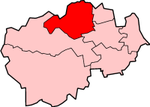
Derwentside

Derwentside
Derwentside District
Derwentside
Lage in Durham
Status District
Region North East England
Verw.grafschaft Durham
Verwaltungssitz Consett
Fläche 270,79 km² (168.)
Einwohner 85.074 (273.)
Stand 2001
ONS-Code 20UD
Website -
Gründung 1974
Auflösung 2009

Derwentside war ein District in der Grafschaft Durham in England, der nach dem Fluss Derwent benannt ist. Verwaltungssitz war die Stadt Consett. Weitere bedeutende Orte des ehemaligen Districts waren Lanchester und Stanley. Es bestand eine Städtepartnerschaft mit Werdohl in Deutschland.

Der Bezirk wurde am 1. April 1974 gebildet und entstand aus der Fusion der Urban Districts Consett und Stanley sowie des Rural District Lanchester. Am 1. April 2009 wurden neben Derwentside alle Dictricts im County Durham abgeschafft und zur Unitary Authority Durham zusammengefasst.


Wikimedia Foundation.

Игры ⚽ Поможем написать реферат

Schlagen Sie auch in anderen Wörterbüchern nach:

  • Derwentside — Coordinates: 54°52′01″N 1°45′36″W / 54.867°N 1.760°W / 54.867; 1.760 …   Wikipedia

  • Derwentside — ▪ district, England, United Kingdom       district, administrative and historic county of Durham, northeastern England, located in the north central part of the county about 12 miles (20 km) southwest of the city of Newcastle upon Tyne.… …   Universalium

  • Derwentside Independents — Leader Watts Stelling Founded 2001 Headquarters Leadgate …   Wikipedia

  • Derwentside College — Derwentside College[1] Type Further education Principal Albert Croney …   Wikipedia

  • Derwentside local elections — Derwentside Council in County Durham, England is elected every four years. The district council will be abolished in 2009 to become part of a new unitary council.[1] Contents 1 Political control 2 Council elections …   Wikipedia

  • 20UD — Derwentside District Lage in Durham Status District Region North East England Verw.grafschaft …   Deutsch Wikipedia

  • Annfield Plain — infobox UK place country = England static static image caption= latitude= 54.85 longitude= 01.73 official name =Annfield Plain population = shire district= shire county= County Durham metropolitan borough= metropolitan county = region=North East… …   Wikipedia

  • Stanley, County Durham — infobox UK place country = England official name= Stanley latitude= 54.8672 longitude= 1.6922 population = 16,306 (2001) [http://www.durham.gov.uk/DurhamCC/usp.nsf/pws/your+county+ +2001+census+summary+sheets] shire district= Derwentside region=… …   Wikipedia

  • Lanchester, County Durham — Town Name: Lanchester, DerwentsideTown Population 5,252COUNTY DURHAMLanchester is a village and civil parish in the district of Derwentside, County Durham, England. It is eight miles to the west of the city of Durham and 8 km (5… …   Wikipedia

  • Consett — See also: Consett (UK Parliament constituency) Coordinates: 54°51′N 1°50′W / 54.85°N 1.83°W / 54.85; 1.83 …   Wikipedia

Share the article and excerpts

Direct link
Do a right-click on the link above
and select “Copy Link”