Dorre Island

Dorre Island

Vorlage:Infobox Insel/Wartung/Höhe fehlt

Dorre Island
Lage der Dorre Island in der Shark Bay
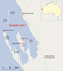
Gewässer Indischer Ozean
Geographische Lage 25° 7′ S, 113° 6′ O-25.121388888889113.10194444444Koordinaten: 25° 7′ S, 113° 6′ O
Dorre Island (Westaustralien)
Dorre Island
Länge 31,8 km
Breite 3,8 km
Fläche 60 km²
Einwohner (unbewohnt)

Dorre Island ist eine 30 Kilometer lange, sehr schmale Insel vor der Westküste von Australien.

Die 57 Kilometer südwestlich der Stadt Carnarvon gelegene Insel war Anfang des 19. Jahrhunderts Standort einer medizinischen Isolationsstation. Das jetzt unbewohnte und etwa 60 km² große Eiland ist nur durch einen 500 Meter breiten Sund vom nördlichen Bernier Island getrennt.

Die Insel bietet heute Heimat für einige der letzten Exemplare des Gebänderten Hasenkängurus (Lagostrophus fasciatus).

Sie gehört zum Bernier and Dorre Island Nature Reserve, einem in der Shark Bay in Western Australia gelegenen Naturreservat, und darf zum Schutz der Tierwelt nur mit Sondergenehmigung betreten werden.

Weblinks


Wikimedia Foundation.

Игры ⚽ Поможем написать реферат

Schlagen Sie auch in anderen Wörterbüchern nach:

  • Dorre Island — Geography Location Shark Bay Country Australia S …   Wikipedia

  • Bernier and Dorre Island Nature Reserve — Bernier and Dorre Islands Nature Reserve …   Deutsch Wikipedia

  • Bernier Island — Vorlage:Infobox Insel/Wartung/Höhe fehlt Bernier Island Lage von Bernier Island in der Shark Bay Gewässer I …   Deutsch Wikipedia

  • Bernier Island — is one of three islands that comprise the Bernier and Dorre Island Nature Reserve in the Shark Bay World Heritage area in Western Australia. [Hancock, Sue; Brown, Paul; and Stephens, Burke. (2000). Shark Bay Terrestrial Reserves Management Plan… …   Wikipedia

  • Ile Dorre — Île Dorre 25° 10′ 00″ S 113° 03′ 00″ E / 25.1667, 113.0500 …   Wikipédia en Français

  • Koks Island — Vorlage:Infobox Insel/Wartung/Bild fehltVorlage:Infobox Insel/Wartung/Höhe fehlt Koks Island Gewässer Indischer Ozean Geographische Lage …   Deutsch Wikipedia

  • Île Dorre — 25° 10′ 00″ S 113° 03′ 00″ E / 25.1667, 113.0500 …   Wikipédia en Français

  • Bernierinsel — Vorlage:Infobox Insel/Wartung/Bild fehltVorlage:Infobox Insel/Wartung/Höhe fehlt Bernier Island Gewässer Indischer Ozean Geographische Lage …   Deutsch Wikipedia

  • Boodie — Taxobox name = BoodieMSW3 Groves | pages = 57] fossil range=Late Oligocene Recent status = NT status system = iucn3.1 trend = increasing regnum = Animalia phylum = Chordata classis = Mammalia infraclassis = Marsupialia ordo = Diprotodontia… …   Wikipedia

  • Timeline of Aboriginal history of Western Australia — This is a Timeline of Aboriginal history of Western Australia 1629 1829Aboriginal life in the two centuries from 1629 to 1829, was characterized by the increased presence of Europeans around the Western Australian coastline. First contact,… …   Wikipedia

Share the article and excerpts

Direct link
Do a right-click on the link above
and select “Copy Link”