Agalega Islands

Agalega Islands

w1

Agalega-Inseln
Karte der Agalega-Inseln
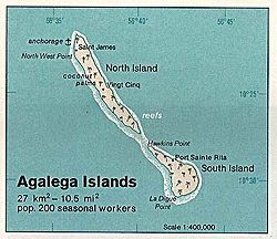
Gewässer Indischer Ozean
Anzahl der Inseln 2
Hauptinsel North Island
Gesamtfläche 27 km²dep1
Einwohner etwa 300 dep1
Geographische Lage 10° 25′ S, 56° 39′ O-10.41666666666756.657Koordinaten: 10° 25′ S, 56° 39′ O
Lage der Agalega-Inseln

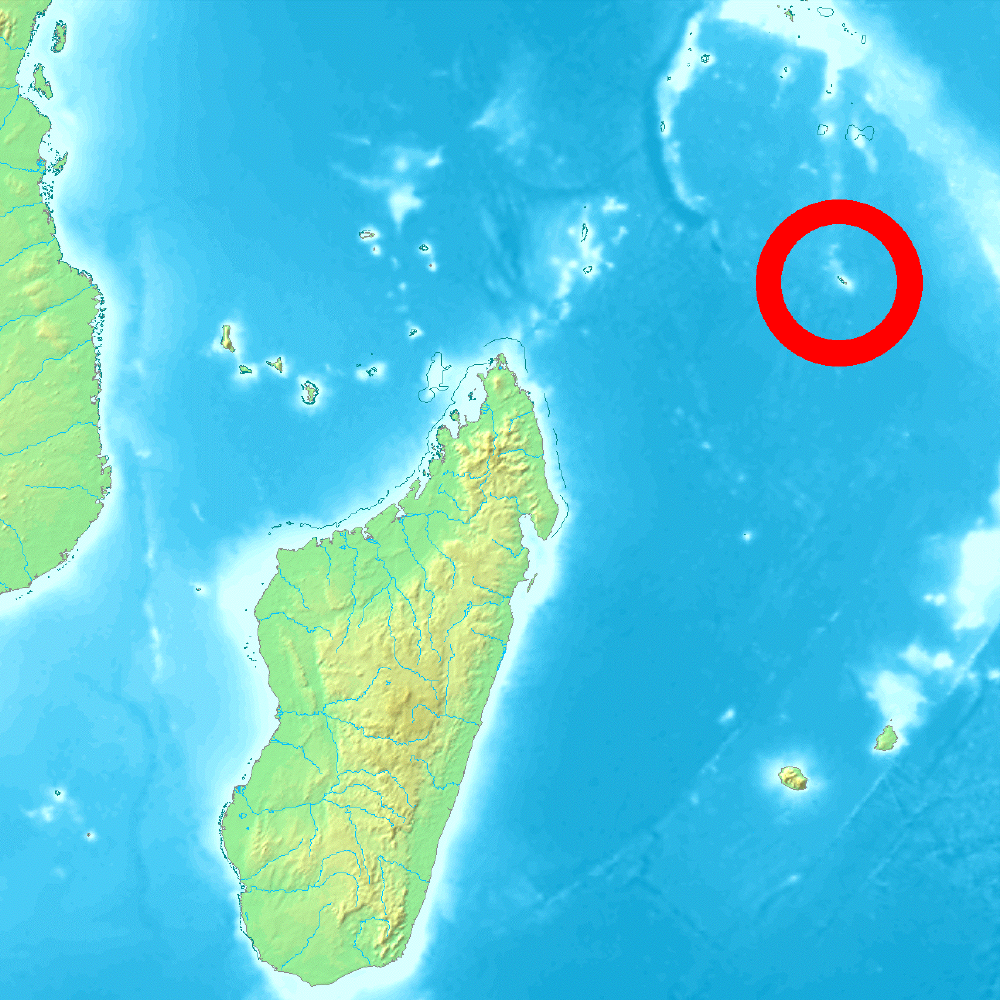
Die Agalega-Inseln sind eine kleine Inselgruppe, bestehend aus zwei Inseln, im Indischen Ozean. Politisch gehören sie zu Mauritius, obgleich sie 1.100 km nördlich der Insel Mauritius und damit näher an Madagaskar oder den Seychellen liegen. Ihre Landfläche beträgt 27 km².

Benannt wurden die Inseln möglicherweise nach einem der Schiffe („La Galega“) des portugiesischen Seefahrers Pedro Mascarenhas, der die Inseln um 1512 bereiste.

Auf der Nordinsel (12,5 × 1,5 km) befinden sich eine Landebahn für Flugzeuge, der Hauptort Vingt Cinq sowie das Dorf La Fourche, auf der Südinsel (7 × 4,5 km) liegen das Dorf Sainte Rita sowie eine Wetterstation. Die Inselgruppe hat etwa 300 Bewohner.

Hauptwirtschaftszweig der Inseln ist die Produktion von Kopra und Kokosöl. Für den Eigenbedarf wird Fischerei betrieben. Bis vor kurzem war auf den Inseln kein Bargeld im Umlauf, der Geldverkehr wurde mit staatlichen Gutscheinen vorgenommen.

Auf den Inseln existiert eine endemische Taggecko-Art (Phelsuma borbonica agalegae). Zu den weiteren Landtieren gehört eine Population von Ibissen.

Weblinks


Wikimedia Foundation.

Игры ⚽ Нужен реферат?

Schlagen Sie auch in anderen Wörterbüchern nach:

  • Agalega Islands — Infobox Islands name = Agalega Islands image caption = locator image caption = locator native name = native name link = location = Indian Ocean coordinates= coord|10|25|S|56|35|E| archipelago = total islands = 2 major islands = area = 70 km²… …   Wikipedia

  • Agalega Islands — Admin ASC 1 Code Orig. name Agalega Islands Country and Admin Code MU.21 MU …   World countries Adminstrative division ASC I-II

  • Agalega Islands — ▪ islands, Indian Ocean       two island dependency of Mauritius, in the western Indian Ocean. It consists of North Island and South Island. They lie about 600 miles (1,000 km) north of Mauritius and have a total land area of 27 square miles (70… …   Universalium

  • Agaléga — Carte de l archipel d Agaléga. Géographie Pays …   Wikipédia en Français

  • Agalega — Agaléga 10° 25′ 05″ S 56° 37′ 57″ E / 10.41813889, 56.63246667 …   Wikipédia en Français

  • Agalega day gecko — Taxobox name = Agalega day gecko regnum = Animalia phylum = Chordata classis = Reptilia ordo = Squamata familia = Gekkonidae subfamilia = Gekkoninae genus = Phelsuma species = P. borbonica subspecies = P. b. agalegae trinomial = Phelsuma… …   Wikipedia

  • Agalega Creole — language name=Agalega Creole nativename=Kreol states=Agalega Islands speakers …   Wikipedia

  • Agalega-Inseln — NASA Bild der Nordinsel von Agalega Gewässer Indischer Ozean …   Deutsch Wikipedia

  • Islas Agalega — (Archipel d Agaléga Agalega Islands) Localización geográfica / administrativa Océano (mar) Océano Índico Ecorregió …   Wikipedia Español

  • Culture of the Indian Ocean Islands — The culture of the Indian Ocean islands reflects the ethnic diversity, history, politics, music, dance, food, drink, arts, sports and international influences in that region. The area includes Zanzibar (Unguja and Pemba Island), Madagascar,… …   Wikipedia

Share the article and excerpts

Direct link
Do a right-click on the link above
and select “Copy Link”