- East Berbice-Corentyne
-
East Berbice-Corentyne 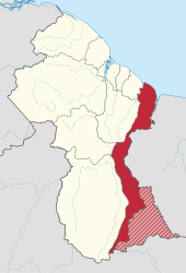
Basisdaten Staat Guyana Fläche 36.234 km² Einwohner 123.695 (2002-09-15) Dichte 3,4 Einwohner pro km² ISO 3166-2 GY-EB East Berbice-Corentyne ist die östliche Region Guyanas. Sie grenzt an den Atlantischen Ozean im Norden, an Suriname im Osten, Brasilien im Süden und die Regionen Mahaica-Berbice, Upper Demerara-Berbice, Potaro-Siparuni und Upper Takutu-Upper Essequibo im Westen. In der Region gibt es die Städte New Amsterdam, Corriverton, Mara und Rose Hall.
Der Corantijn ist die natürliche Grenze zu Suriname, in seinem südlichen Verlauf gibt es im sogenannten New River Triangle Grenzkonflikte mit Suriname.
 Regionen von Guyana
Barima-Waini | Cuyuni-Mazaruni | Demerara-Mahaica | East Berbice-Corentyne | Essequibo Islands-West Demerara | Mahaica-Berbice | Pomeroon-Supenaam | Potaro-Siparuni | Upper Demerara-Berbice | Upper Takutu-Upper Essequibo
Wikimedia Foundation.
Schlagen Sie auch in anderen Wörterbüchern nach:
East Berbice-Corentyne — Berbice Oriental Courantyne Berbice Oriental Courantyne East Berbice Corentyne (Région 6) Administration Pays Guyana Type … Wikipédia en Français
East berbice-corentyne — Berbice Oriental Courantyne Berbice Oriental Courantyne East Berbice Corentyne (Région 6) Administration Pays Guyana Type … Wikipédia en Français
East Berbice-Corentyne — (Region 6) is one of ten regions in Guyana covering the whole of the east of the country. It borders the Atlantic Ocean to the north, Suriname to the east, Brazil to the south and the regions of Mahaica Berbice, Upper Demerara Berbice, Potaro… … Wikipedia
East Berbice-Corentyne — Sp Rytų Berbisas Kòranteinas Ap East Berbice Corentyne L Gajanos adm. sritis … Pasaulio vietovardžiai. Internetinė duomenų bazė
East Berbice-Corentyne — Admin ASC 1 Code Orig. name East Berbice Corentyne Country and Admin Code GY.13 GY … World countries Adminstrative division ASC I-II
Kumaka, East Berbice-Corentyne — Kumaka is a village in the East Berbice–Corentyne region of Guyana. It stands on the right bank of the upper Essequibo River, about 35 km above Apoteri and the confluence of the Rupununi River with the Essequibo, at an elevation of 105 metres… … Wikipedia
Berbice Oriental-Courantyne — East Berbice Corentyne (Région 6) Administration Pays Guyana Type … Wikipédia en Français
Mahaica-Berbice — (Region 5) is a region of Guyana, bordering the Atlantic Ocean to the north, the region of East Berbice Corentyne to the east, the region of Upper Demerara Berbice to the south and the region of Demerara Mahaica to the west. It contains the towns … Wikipedia
Mahaica-Berbice — Basisdaten Staat Guyana … Deutsch Wikipedia
Upper Demerara-Berbice — Basisdaten Staat Guyana … Deutsch Wikipedia
East Berbice-Corentyne

18+
© Academic, 2000-2026
- Kontaktieren Sie uns: Unterstützung, Werbung
Wörterbücher Export, schritte mit PHP, Joomla, Drupal, WordPress, MODx.