Ekuk

Ekuk
Ekuk
Ekuk (Alaska)
Ekuk
Ekuk
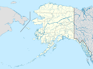
Lage in Alaska
Basisdaten
Staat: Vereinigte Staaten
Bundesstaat: Alaska
Borough:

Unorganized Borough

Koordinaten: 58° 49′ N, 158° 33′ W58.8149-158.55765Koordinaten: 58° 49′ N, 158° 33′ W
Zeitzone: Alaska Standard Time (UTC−9)
Einwohner: 2 (Stand: 2000)
Bevölkerungsdichte: 0,2 Einwohner je km²
Fläche: 12,2 km² (ca. 5 mi²)
davon 12,2 km² (ca. 5 mi²) Land
Höhe: 5 m
Vorwahl: +1 907

Ekuk ist ein Dorf in der Dillingham Census Area in Alaska. Nach der Volkszählung 2000 lebten dort zwei Personen. Die Arbeiter der Konservenfabriken und die Besatzungen der kommerziellen Fischfangboote erwecken das Dorf im Sommer zum Leben.

Geschichte

Ekuk bedeutet „das letzte Dorf unten“ und deutet an, dass Ekuk das südlichste Dorf an der Nushagak Bay, einem Seitenarm der Bristol Bay, ist. Das Dorf wird in russischen Aufzeichnungen von 1824 und 1828 als Ekouk und Seleniye Ikuk erwähnt. Man nimmt an, dass Ekuk einstmals ein großes Dorf der Inuit war. Bevor 1903 die erste Konservenfabrik in Ekuk eröffnet wurde, zogen viele Einwohner zur Moravian Mission bei Carmel. Heute ist nur die Familie des Wachmanns der Konservenfabrik ganzjährig vorort.

Anlegestelle von Ekuk


Weblinks


Wikimedia Foundation.

Игры ⚽ Поможем сделать НИР

Schlagen Sie auch in anderen Wörterbüchern nach:

  • Ekuk, Alaska — Infobox Settlement official name = Ekuk, Alaska nickname = image map caption = Location in the state of Alaska subdivision type = subdivision name = leader title = leader name = area magnitude = area total km2 = area land km2 = area water km2 =… …   Wikipedia

  • Folwark Łękuk — (Łękuk Mały,Польша) Категория отеля: Адрес: Łękuk Mały 8, 11 510 Łękuk Mały, Польша …   Каталог отелей

  • KKU — Ekuk, Alaska USA (Regional » Airport Codes) …   Abbreviations dictionary

  • KKU — Ekuk, AK, USA internationale Flughafen Kennung …   Acronyms

  • KKU — Ekuk, AK, USA internationale Fughafen Kennung …   Acronyms von A bis Z

  • National Register of Historic Places listings in Dillingham Census Area, Alaska — Location of the Dillingham Census Area in Alaska This is a list of the National Register of Historic Places listings in Dillingham Census Area, Alaska. This is intended to be a complete list of the properties and districts on the National… …   Wikipedia

  • Crescent Porter Hale — (1872–1937) was an American industrialist who was involved in the canned salmon industry in Bristol Bay, Alaska throughout his adult life. Contents 1 Early life 2 North Alaska Salmon Company 3 1936 fire …   Wikipedia

  • Liste der Registered Historic Places im Bristol Bay Borough — Die Liste der Registered Historic Places im Bristol Bay Borough führt alle Bauwerke und historischen Stätten im Bristol Bay Borough des US Bundesstaates Alaska auf, die in das National Register of Historic Places aufgenommen wurden.… …   Deutsch Wikipedia

  • Список аэропортов штата Аляска — Соединённых Штатов Америки, сгруппированных по типу. Содержит все гражданские и военные аэропорты штата. Некоторые частные и ныне не используемые аэропорты могут находиться в списке (например, если ФАА зафиксированы коммерческие перевозки или… …   Википедия

  • Dillingham Census Area, Alaska — Dillingham Census Area is a census area located in the state of Alaska, United States. As of the 2000 census, the population was 4,922. It is part of the unorganized borough and therefore has no borough seat. Its largest community by far is the… …   Wikipedia

Share the article and excerpts

Direct link
Do a right-click on the link above
and select “Copy Link”