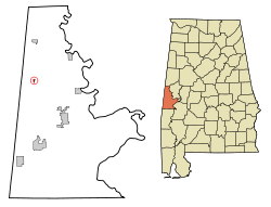
Emelle

Emelle
Emelle
Sumter County Alabama Incorporated and Unincorporated areas Emelle Highlighted.svg
Lage in Alabama
Basisdaten
Staat: Vereinigte Staaten
Bundesstaat: Alabama
County:

Sumter County

Koordinaten: 32° 44′ N, 88° 19′ W32.73-88.31444444444479Koordinaten: 32° 44′ N, 88° 19′ W
Zeitzone: Central Standard Time (UTC−6)
Einwohner: 30 (Stand: 2005)
Bevölkerungsdichte: 50 Einwohner je km²
Fläche: 0,6 km² (ca. 0 mi²)
davon 0,6 km² (ca. 0 mi²) Land
Höhe: 79 m
Postleitzahl: 35459
Vorwahl: +1 205
FIPS: 01-23872
GNIS-ID: 0155060

Emelle ist ein Ort im Sumter County, Alabama, USA. Die Gesamtfläche des Ortes beträgt 0,6 km². Nach einer Schätzung aus dem Jahr 2005 hatte Emelle 30 Einwohner und liegt an der Alabama State Route 17.

Demographie

Nach der Volkszählung aus dem Jahr 2000 hatte Emelle 31 Einwohner, die sich auf 15 Haushalte und 10 Familien verteilten. Die Bevölkerungsdichte betrug somit 54,4 Einwohner/km². 93,55 % der Bevölkerung waren afroamerikanisch, 6,45 % weiß. In 33,3 % der Haushalte lebten Kinder unter 18 Jahren.

Quelle


Wikimedia Foundation.

Игры ⚽ Нужна курсовая?

Schlagen Sie auch in anderen Wörterbüchern nach:

  • Emelle — Emelle, AL U.S. town in Alabama Population (2000): 31 Housing Units (2000): 16 Land area (2000): 0.216882 sq. miles (0.561723 sq. km) Water area (2000): 0.000000 sq. miles (0.000000 sq. km) Total area (2000): 0.216882 sq. miles (0.561723 sq. km)… …   StarDict's U.S. Gazetteer Places

  • Emelle, AL — U.S. town in Alabama Population (2000): 31 Housing Units (2000): 16 Land area (2000): 0.216882 sq. miles (0.561723 sq. km) Water area (2000): 0.000000 sq. miles (0.000000 sq. km) Total area (2000): 0.216882 sq. miles (0.561723 sq. km) FIPS code:… …   StarDict's U.S. Gazetteer Places

  • Emelle, Alabama — Infobox Settlement official name = Emelle, Alabama settlement type = Town imagesize = image caption = image imagesize = image caption = image mapsize = 250px map caption = Location in Sumter County and the state of Alabama mapsize1 = map caption1 …   Wikipedia

  • 35459 — Emelle, Al (Miscellaneous » ZIP Codes) …   Abbreviations dictionary

  • National Register of Historic Places listings in Sumter County, Alabama — Location of Sumter County in Alabama This is a list of the National Register of Historic Places listings in Sumter County, Alabama. This is intended to be a complete list of the properties and districts on the National Register of Historic Places …   Wikipedia

  • Alabama State Route 116 — Basisdaten Gesamtlänge:  10 mi/16 km Eröffnung:  …   Deutsch Wikipedia

  • Liste der wichtigsten Städte in Alabama — Abbeville Abel Abernant Ada Adamsville Addison Adger Akron Alabama Port Alabaster Alberta Albertville Alexander City Alexandria Aliceville Allgood Alma Alpine Alton Altoona Andalusia Anderson Annemanie …   Deutsch Wikipedia

  • Alabama State Route 28 — Basisdaten Gesamtlänge:  97 mi/156 km Eröffnung:  19 …   Deutsch Wikipedia

  • Sumter County, Alabama — Infobox U.S. County county = Sumter County state = Alabama map size = 175 founded = December 18, 1832 seat =Livingston largest city = Livingston area total sq mi =913 area land sq mi =905 area water sq mi =8 area percentage = (0.92%) census yr =… …   Wikipedia

  • Cuba, Alabama —   Town   Welcome sign to Cuba …   Wikipedia

Share the article and excerpts

Direct link
Do a right-click on the link above
and select “Copy Link”