Flat Island (Mauritius)

Flat Island (Mauritius)

Vorlage:Infobox Insel/Wartung/Bild fehltw1Vorlage:Infobox Insel/Wartung/Fläche fehltVorlage:Infobox Insel/Wartung/Höhe fehlt

Flat Island
Gewässer Indischer Ozean
Geographische Lage 19° 52′ 46,76″ S, 57° 40′ 4,78″ O-19.87965646527857.667995719444Koordinaten: 19° 52′ 46,76″ S, 57° 40′ 4,78″ O
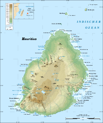
Die Hauptinsel Mauritius. Flat Island oder Île Plate ist nördlich der Spitze oberhalb von Coin du Mere zu erkennen

Flat Island, auf Französisch Île Plate, ist eine zum Staat Mauritius gehörende Insel, die etwa 11 km von Cap Malheureux, dem nördlichsten Punkt Hauptinsel Mauritius in der Nachbarschaft der Inseln Round Island, Île aux Serpents und Coin de Mire liegt. Unmittelbar südwestlich neben Flat Island liegt die vegetationslose Insel Îlot Gabriel. Bei Niedrigwasser ist diese zu Fuß von Flat Island aus zu erreichen. Nördlich befindet sich die kleine Felseninsel Pigeon Rock.

Auf Flat Island befindet sich neben einem der zwei aktiven Leuchttürme von Mauritius auch ein Friedhof aus dem 19. Jahrhundert, als die Insel von den Briten als Quarantäne-Insel benutzt wurde. Hier wurden Menschen, die der Malaria, den Pocken oder anderen Krankheiten erlegen waren, beerdigt.

Heute ist die Insel ein touristisches Ziel für Katamaranfahrten und Tauchgänge.

Der Literatur-Nobelpreisträger Jean-Marie Gustave Le Clézio hat Flat Island und seiner Vergangenheit als Quarantäneinsel mit seinem überwiegend hier spielenden Roman Ein Ort fernab der Welt ein literarisches Denkmal gesetzt.


Wikimedia Foundation.

Игры ⚽ Нужно решить контрольную?

Schlagen Sie auch in anderen Wörterbüchern nach:

  • Flat Island — ist der Name mehrerer Inseln, u.a.: zu Australien gehörig Flat Island (Australien), der westlichste Punkt Australiens bei Mauritius, siehe Flat Island (Mauritius) vor Hongkong, siehe Flat Island (Hongkong) zu den Falklandinseln gehörig, auch Flat …   Deutsch Wikipedia

  • Islets of Mauritius — The Islets of Mauritius includes nearly a hundred tiny islets and rocks scattered around the coast of Mauritius as well as Rodrigues. Contents 1 Île aux Cerfs 2 Round Island 3 Île de la Passe 4 …   Wikipedia

  • Round Island skink — Taxobox name = Round Island skink status = VU status system = iucn2.3 regnum = Animalia phylum = Chordata classis = Reptilia (paraphyletic) unranked ordo = Sauria ordo = Squamata (paraphyletic) infraordo = Scincomorpha familia = Scincidae… …   Wikipedia

  • Liste der Inseln von Mauritius — Die Liste der Inseln von Mauritius führt alle neben der namensgebenden Hauptinsel zum Staat Mauritius gehörigen Inseln und Inselgruppen auf. Nur die an erster Stelle aufgeführte Insel Rodrigues hat dabei eine Fläche, die über wenige… …   Deutsch Wikipedia

  • Tromelin Island — Infobox Country native name = Île Tromelin conventional long name = Tromelin Island symbol type = Coat of arms national motto = Liberté, égalité, fraternité national anthem = La Marseillaise map caption = Location of the Scattered islands in the… …   Wikipedia

  • Christmas Island — This article is about the Australian territory in the Indian Ocean. For other uses, see Christmas Island (disambiguation). Territory of Christmas Island …   Wikipedia

  • Corregidor Island — Corregidor Map of Corregidor Island …   Wikipedia

  • Juan de Nova Island — Infobox Country native name = Île Juan de Nova conventional long name = Juan de Nova Island symbol type = Coat of arms national motto = Liberté, égalité, fraternité national anthem = La Marseillaise map caption = Location of the Scattered islands …   Wikipedia

  • D'Arros Island — Map of D Arros Island and neighboring St. Joseph Atoll D Arros Island is part of the Amirante Islands which are considered part of the Outer Islands of the Seychelles. The island is located only 2 km west of the northern part of St. Joseph… …   Wikipedia

  • Tromelin Island — Introduction Tromelin Island Background: First explored by the French in 1776, the island came under the jurisdiction of Reunion in 1814. At present, it serves as a sea turtle sanctuary and is the site of an important meteorological station.… …   Universalium

Share the article and excerpts

Direct link
Do a right-click on the link above
and select “Copy Link”