- Floresta (Buenos Aires)
-
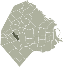 Lage von Floresta in Buenos Aires
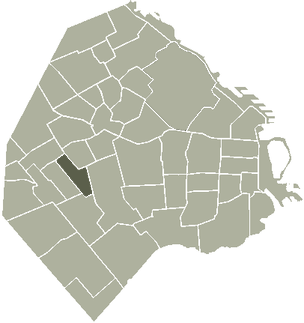
Floresta ist ein Stadtteil westlich des Zentrums der argentinischen Hauptstadt Buenos Aires. Er hat fast 40.000 Einwohner (Stand von 2001) auf einer Fläche von 2,4 km².
Inhaltsverzeichnis
Lage
Im Norden schließt sich Monte Castro an, im Osten Flores, im Süden Parque Avellaneda und im Westen Villa Luro.
Geschichte
Der heutige Stadtteil Floresta wurde um einen Bahnhof herum angelegt, der am 29. August 1857 eröffnet wurde. Es war die erste Eisenbahnverbindung Argentiniens, die von der heute nicht mehr existierenden Station „Plaza Del Parque“ in Buenos Aires hierher führte.[1] Zur Erinnerung daran wird jedes Jahr am 29. August der Stadtteiltag begangen.
1914 wurde auf einem Grundstück, das bis dahin zu einem Kloster gehörte, der „Avellaneda Park“ angelegt. Der italienische Immigrant Felix Barabino baute sich in Floresta ein Haus, das zur damaligen Zeit das imposanteste des Stadtteils war. Heute ist dort der Historische Verein Floresta untergebracht, der dort auch eine Bibliothek unterhält.
Sport
In Floresta ist der Fußballverein „Club Atlético All Boys“ zuhause, der im Estadio Islas Malvinas spielt. Ursprünglich war auch der Club Atlético Vélez Sársfield hier beheimatet. Er zog aber um nach Liniers.
Bekannte Bewohner
- Roberto Arlt, Schriftsteller
- Gabino Ezeiza, Musiker
- Eduardo Gudiño Kieffer, Schriftsteller
Weblinks
 Commons: Floresta – Sammlung von Bildern und/oder Videos und Audiodateien
Einzelnachweise
- ↑ wordpress.com: Die erste Eisenbahn in Argentinien, abgefragt am 29. August 2011

Agronomía | Almagro | Balvanera | Barracas | Belgrano | Boedo | Caballito | Chacarita | Coghlan | Colegiales | Constitución | Flores | Floresta | La Boca | La Paternal | Liniers | Mataderos | Monte Castro | Montserrat | Nueva Pompeya | Núñez | Palermo | Parque Avellaneda | Parque Chacabuco | Parque Chas | Parque Patricios | Puerto Madero | Recoleta | Retiro | Saavedra | San Cristóbal | San Nicolás | San Telmo | Vélez Sársfield | Versalles | Villa Crespo | Villa del Parque | Villa Devoto | Villa Lugano | Villa Luro | Villa Mitre | Villa Ortúzar | Villa Pueyrredón | Villa Real | Villa Riachuelo | Villa Santa Rita | Villa Soldati | Villa Urquiza
Wikimedia Foundation.
Schlagen Sie auch in anderen Wörterbüchern nach:
Floresta (Buenos Aires) — Saltar a navegación, búsqueda Para otros usos de este término, véase Floresta (desambiguación). Floresta Datos Pob … Wikipedia Español
Floresta, Buenos Aires — Buenos Aires Barrio barrio = Floresta area = 2.4 population = 39 437 density = 16 447 comuna = C10 site list = Estadio Islas Malvinas comments =Floresta is a neighbourhood located in the west of the Buenos Aires Autonomous city.The district was… … Wikipedia
Estación Floresta (Buenos Aires) — Saltar a navegación, búsqueda Este artículo trata sobre una estación de ferrocarril argentina. Para la estación del Metro de Medellín, en Colombia, véase Estación Floresta (Metro de Medellín). Floresta … Wikipedia Español
Buenos Aires — Karte Wappen … Deutsch Wikipedia
Buenos Aires Central Business District — Microcentro Unofficial Barrio … Wikipedia
Nuñez (Buenos Aires) — Lage von Núñez in Buenos Aires Núñez ist ein Stadtteil von Buenos Aires. Er ist 3,9 km² groß und hat ca. 50.000 Einwohner (Stand von 2001). Núñez liegt am nördlichen Stadtrand am Ufer des Río de la Plata. Südöstlich davon befindet sich Belgrano,… … Deutsch Wikipedia
Metrobús (Buenos Aires) — Metrobús Estación terminal Pacífico … Wikipedia Español
Autonome Stadt Buenos Aires — Buenos Aires Karte Wappen … Deutsch Wikipedia
Buenos Aires — This article is about the Argentine city; the name may also refer to Buenos Aires Province or the Buenos Aires Central Business District (also known as the Porteña City or port city). For other uses, see Buenos Aires (disambiguation). Buenos… … Wikipedia
Buenos Aires Western Railway — The Buenos Aires Western Railway (BAW) (in Spanish: Ferrocarril Oeste de Buenos Aires) was one of the Big Four RailGauge|5.5ft|al=off|lk=on broad gauge British owned companies that built and operated railway networks in Argentina. The company… … Wikipedia
Floresta (Buenos Aires)
18+
© Academic, 2000-2026
- Kontaktieren Sie uns: Unterstützung, Werbung
Wörterbücher Export, schritte mit PHP, Joomla, Drupal, WordPress, MODx.