Fort Providence

Fort Providence
Fort Providence
Lage in Kanada
Fort Providence (Kanada)
Fort Providence
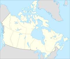
Fort Providence
Staat: Kanada
Territorium: Nordwest-Territorien
Region: Dehcho Region
Koordinaten: 61° 21′ N, 117° 39′ W61.352594-117.653798Koordinaten: 61° 21′ N, 117° 39′ W
Einwohner: 727 (Stand: 2006)

Fort Providence (Slavey: Zhahti Koe „Missionshaus“) ist ein 160 Meter hoch gelegener Weiler in der Region Dehcho in den Nordwest-Territorien in Kanada. Westlich des Großer Sklavensee gelegen, kann der Ort bei jedem Wetter über die Straße erreicht werden: Durch den Yellowknife Highway, und es ist geplant, eine Brücke nahe dem Ort über den Mackenzie zu bauen, um die Eisbrücke im Winter und die Fähre abzulösen und eine ganzjährige Überquerung zu ermöglichen.

Fort Providence ist als Ausrichter des jährlichen Mackenzie Daze-Festes bekannt. Dieses findet im August statt.

Die Einwohnerzahl beträgt laut kanadischem Zensus von 2006 727 und die Bevölkerungsdichte 2,8. Die Mehrheit gehört dem Volk der Dene an.[1]

Die Dene von Fort Providence werden von dem Deh Gah Gotie Dene Council repräsentiert[2] und die Métis durch Fort Providence Métis Local 57.[3] Beide Gruppen gehören zu den Dehcho First Nations.[4]

Der Ort besitzt einen Flugplatz. Er liegt 5,6 km östlich des Weilers und heißt Fort Providence Water Aerodrome.

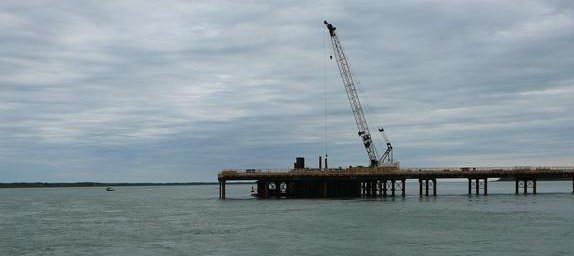
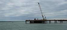
Mackenzie River Brücke, August 2008

Dieses Foto zeigt die Mackenzie-Brücke im Bau. Die provisorische Brücke wird zum Bau von 5 Stützen für die eigentliche Brücke genutzt.

Einzelnachweise

  1. kanadischer Zensus 2006 Community Profile Fort Providence
  2. Deh Gah Gotie Dene Council
  3. Fort Providence Metis
  4. Dehcho First Nations

Weblinks


Wikimedia Foundation.

Игры ⚽ Поможем решить контрольную работу

Schlagen Sie auch in anderen Wörterbüchern nach:

  • Fort Providence, Northwest Territories — Infobox Settlement name = Fort Providence native name = Zhahti Koe other name = Location map polarx CanadaGeo caption = lon shift = 4.1 label= Fort Providence label size=70 | lat skew=1.2 background = #DDDD22 position=top lat = 61.354722 long =… …   Wikipedia

  • Fort Providence Water Aerodrome — was located 1.5 nautical miles (2.8 km) west of Fort Providence, Northwest Territories, Canada. The airport was listed as abandoned in the 15 March 2007 Canada Flight Supplement.ee also*Fort Providence AirportReferences*WAS …   Wikipedia

  • Fort Providence Airport — is located convert|3|NM|abbr=on|lk=in east of Fort Providence, Northwest Territories, Canada.ee also*Fort Providence Water AerodromeReferences …   Wikipedia

  • Old Fort Providence, Northwest Territories — Old Fort Providence, located near the mouth of Yellowknife Bay, Northwest Territories, Canada, was one of the first fur trading outposts on Great Slave Lake. It was established in 1786 by Peter Pond of the North West Company and later (1789)… …   Wikipedia

  • Providence (disambiguation) — Providence may refer to:In religion: * Divine Providence, by the influence of God * Providence (religion), Jung Myung Seok s new religious movementIn entertainment: * Providence (1977 film), a French/Swiss film * Providence (1991 film), an… …   Wikipedia

  • Providence (Begriffsklärung) — Providence ist der Name mehrerer Städte in den USA, nämlich: Providence (Rhode Island) Providence (Alabama) Providence (Arkansas) Providence (Kentucky) Providence (Louisiana) Providence (New York) Providence (North Carolina) Providence (Utah)… …   Deutsch Wikipedia

  • Fort Smith Region, Northwest Territories — Fort Smith Region is one of Statistics Canada s two census divisions of the Northwest Territories, Canada. It contains more than 77 percent of the population and more than 54 percent of the land area of the Northwest Territories. Its main… …   Wikipedia

  • Fort Smith Region — ist eine der zwei Zensuseinheiten in den Northwest Territories, Kanada. Sie umfasst mehr als 77% der Bevölkerung und mehr als 54% der Fläche der Northwest Territories. Ihr wirtschaftliches Zentrum ist die Hauptstadt Yellowknife. Der kanadische… …   Deutsch Wikipedia

  • Fort Thunder — war ein verlassenes Lagerhaus im Obergeschoss einer Textilfabrik aus der Zeit vor dem Amerikanischen Bürgerkrieg, gelegen in Olneyville, einem Stadtteil von Providence, Rhode Island, in den USA. Von 1995 bis 2001 waren die Räumlichkeiten ein… …   Deutsch Wikipedia

  • Fort Thunder — était un entrepôt d une usine de textile antérieure à la Guerre civile américaine située dans le district Olneyville de Providence (Rhode Island). Le lieu a été utilisé de 1995 à 2001 comme local pour des groupes de musique et des spectacles… …   Wikipédia en Français

Share the article and excerpts

Direct link
Do a right-click on the link above
and select “Copy Link”