Furneaux Group

Furneaux Group
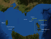
Bass Strait mit Darstellung der Inselgruppen

Die Furneaux-Gruppe (engl. Furneaux Group) ist eine aus 52 Inseln bestehende Inselgruppe am Ostende der Bass Strait zwischen den australischen Bundesstaaten Victoria und Tasmanien.

Die Inseln wurden nach dem britischen Entdecker Tobias Furneaux benannt, der das Gebiet 1773 erforschte. Die Inseln selbst wurden im Februar 1798 von Matthew Flinders erforscht.

Die größten Inseln der Gruppe sind Flinders Island, Cape Barren Island und Clarke Island. Auf Flinders Island befinden sich 5 Siedlungen: Killiecrankie, Emita, Whitemark, Lady Barron, Cape Barren Island und Whitemark. Letzteres ist das Gemeindeverwaltungszentrum der Flinders local government area, das aus den Inseln gebildet wird. Diese Orte haben 800 Einwohner, die Gesamtbevölkerung des Archipels beträgt um 900 Einwohner.

Die historisch bedeutsame Aboriginal Dolly Dalrymple wurde auf den Inseln geboren.[1]

King Island am Westende der Bass Strait und die nordwestlich der Furneaux-Gruppe in Richtung Australien gelegene Kent-Gruppe werden nicht der Inselgruppe zugerechnet.

Inhaltsverzeichnis

Weitere Inseln

Einige weitere Inseln sind:

  • Anderson Island und Little Anderson Island
  • Babel Island
  • Badger Island
  • Curtis Island
  • Doughboy Island
  • Eastern Kangaroo Island
  • Forsyth Island
  • Gread Dog Island und Little Dog Island
  • Goose Island und Little Goose Island
  • Isabella Island
  • Big Green Island Little Green Island
  • Gull Island
  • Long Island
  • Long Islet
  • Chalky Island und Little Chalky Island
  • Mid Woody
  • Mile Island
  • Mt Chappell Island
  • North, Middle und South Pasco Island
  • Prime Seal Island
  • Roydon Island
  • Sentinel Island
  • Storehouse Island
  • Inner und Outer Sister Island
  • Spike Island
  • Tin Kettle Island
  • Oyster Rocks
  • Passage Island
  • Preservation Island
  • Puncheon Island
  • Vansittart Island

Quellen

  1. Ian McFarlane, Dalrymple, Dolly (c. 1808 - 1864), Australian Dictionary of Biography, Supplementary Volume, Melbourne University Press, 2005, p. 94.

Literatur

  • Cumpston, J. S. First visitors to Bass Strait Canberra : Roebuck Society, 1973. ISBN 0-9500858-8-X Roebuck Society publication no. 7.

Weblinks

-40.166666666667148.083333333337Koordinaten: 40° 10′ S, 148° 5′ O


Wikimedia Foundation.

Игры ⚽ Поможем сделать НИР

Schlagen Sie auch in anderen Wörterbüchern nach:

  • Furneaux Group — The Furneaux Group is a group of 52 islands, at the eastern end of Bass Strait, between Victoria and Tasmania, Australia. The islands were named, after British navigator Tobias Furneaux sighted the easten side of these Island after leaving… …   Wikipedia

  • Furneaux Group — /ˈfɜnoʊ grup/ (say fernoh groohp) noun a group of islands in Bass Strait, off the north eastern coast of Tasmania; mutton birding. {named after Tobias Furneaux} …  

  • Furneaux Group — ▪ islands, Australia       cluster of islands and rocks in Bass Strait off northeastern Tasmania, southern Australia. The largest are Flinders, Cape Barren, Clarke, and Chappell. The islands are generally mountainous with rugged coastlines. Major …   Universalium

  • Furneaux-Gruppe — Bass Strait mit Darstellung der Inselgruppen Gewässer Bass Strait …   Deutsch Wikipedia

  • Tobias Furneaux — Captain Tobias Furneaux (August 21, 1735 – September 19, 1781) was an English navigator and Royal Navy officer, who accompanied James Cook on his second voyage of exploration. He was the first man to circumnavigate the world in both… …   Wikipedia

  • Grupo Furneaux — (Furneaux Group) Vista de satélite de las islas Localización geográfica / administrativa …   Wikipedia Español

  • Archipel Furneaux — L archipel Furneaux Carte de Tasmanie avec l archipel Furneaux en haut à droite …   Wikipédia en Français

  • Kent Group — Infobox protected area of Australia | name = Kent Group National Park iucn category = II caption = locator x = 175 locator y = 1 nearest town or city = Launceston coordinates = coord|41|33|03|S|147|40|01|E|type:landmark region:AU area = 165 km²… …   Wikipedia

  • Sisters Island Group, Tasmania — Sisters Island Group (coord|39|41|35|S|147|54|36|E) is an unofficial name appliedcite book last = Brothers first = Nigel authorlink = coauthors = David Pemberton, Helen Pryor, Vanessa Halley title = Tasmania s Offshore Islands : seabirds and… …   Wikipedia

  • Long Island, Hogan Group (Tasmania) — Long Island is a long, narrow granite island, with an area of 22.85 ha, in south eastern Australia. It is part of Tasmania’s Hogan Group, lying in northern Bass Strait between the Furneaux Group and Wilsons Promontory in Victoria.FaunaRecorded… …   Wikipedia

Share the article and excerpts

Direct link
Do a right-click on the link above
and select “Copy Link”