- Gareloi Island
-
Gareloi Island NASA-Bild von Gareloi Island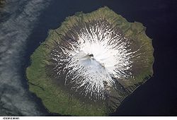
Gewässer Pazifischer Ozean Inselgruppe Delarof Islands Geographische Lage 51° 47′ 21″ N, 178° 47′ 45″ W51.789166666667-178.795833333331573Koordinaten: 51° 47′ 21″ N, 178° 47′ 45″ W 

Länge 9,7 km Breite 8 km Fläche 67 km² Höchste Erhebung Mount Gareloi
1.573 mEinwohner (unbewohnt) Gareloi Island (aleut. Anangusix̂) ist die größte Insel der Delarof Islands, einer Inselgruppe im Westen der Andreanof Islands, die im Südwesten der Aleuten liegen.
Die kleine zum US-Bundesstaat Alaska zählende, unbewohnte Insel hat eine Landfläche von 67 km², ist etwa 9,7 km lang und 8 km breit. Das Zentrum der Insel bildet der 1573 m hohe aktive Schichtvulkan Mount Gareloi.
Weblinks
Schlagen Sie auch in anderen Wörterbüchern nach:
Gareloi Island — Gareloi (Anangusix̂[1] en aléoute) est la plus grande des îles Delarof, dans l arc des îles Aléoutiennes, en Alaska. Il s agit d une une île volcanique inhabitée de 67,23 km2 (9,7 de long et 8 km de large) située entre la Tanaga Pass et l… … Wikipédia en Français
Gareloi Island — Location map Alaska label= lat=51.925726 long= 182.799057 position=right width=250 float=right caption=Location in AlaskaGareloi (Anangusix̂ [Bergsland, K Aleut Dictionary Fairbanks: Alaska Native Language Center, 1994] in Aleut) is a volcanic… … Wikipedia
Gareloi — Island Gareloi (Anangusix̂[1] en aléoute) est la plus grande des îles Delarof, dans l arc des îles Aléoutiennes, en Alaska. Il s agit d une une île volcanique inhabitée de 67,23 km2 (9,7 de long et 8 km de large) située entre la Tanaga Pass… … Wikipédia en Français
Galeroi Island — Gareloi Island Gareloi (Anangusix̂[1] en aléoute) est la plus grande des îles Delarof, dans l arc des îles Aléoutiennes, en Alaska. Il s agit d une une île volcanique inhabitée de 67,23 km2 (9,7 de long et 8 km de large) située entre la… … Wikipédia en Français
Mount Gareloi — Südflanke des Mount Gareloi Höhe 1.573 m … Deutsch Wikipedia
Île Gareloi — 51°47′08.6″N 178°47′56″O / 51.785722, 178.79889 … Wikipédia en Français
Nunivak Island — Nunivak Maskette – Nunivak … Wikipedia
Medny Island — Map showing position of Commander Islands to the east of Kamchatka. The smaller island in the east is Medny and the larger island is Bering Island. Medny Island (also spelled Mednyy, Russian: остров Медный, sometimes called Copper Island in… … Wikipedia
Unalaska Island — Unalaska Native name: Nawan Alaxsxa[1] Map of the island … Wikipedia
Nelson Island (Alaska) — Nelson Native name: Qaluyaaq … Wikipedia
Gareloi Island


18+
© Academic, 2000-2026
- Kontaktieren Sie uns: Unterstützung, Werbung
Wörterbücher Export, schritte mit PHP, Joomla, Drupal, WordPress, MODx.