- Delarof Islands
-
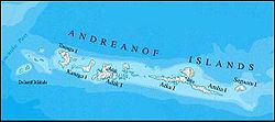
Delarof Islands Karte der Andreanof-Islands, Delarof-Islands im Westen Gewässer Pazifischer Ozean Archipel Aleuten Geographische Lage 51° 23′ N, 178° 58′ W51.383333-178.966667Koordinaten: 51° 23′ N, 178° 58′ W Anzahl der Inseln 11 Gesamtfläche 165,349 km² Einwohner (unbewohnt) Die Delarof Islands sind eine Gruppe kleiner unbewohnter Inseln im äußersten Westen der Andreanof Islands, welche zu den Aleuten gehören. Die Landfläche der Gruppe beträgt 165,349 km². Zu den Delarofs gehören insgesamt elf Inseln. Dies sind:
- Amatignak Island
- Gareloi Island
- Ilak Island
- Kavalga Island
- Ogliuga Island
- Skagul Island
- Tag Islands
- Tanadak Island
- Ugidak Island
- Ulak Island
- Unalga Island
Die Delarofs werden von den Andreanof Islands im Osten durch die Tanaga-Straße getrennt. Die Amchitka-Straße grenzt die Inseln im Westen von den Rat Islands ab.
Die Delarof Islands gehören zum Alaska Maritime National Wildlife Refuge.
Inseln und Inselgruppen der Andreanof IslandsAdak | Agligadak | Amatigis Islands | Amlia | Anagaksik | Argonne | Asuksak | Atka | Aziak | Barbara | Black | Bobrof | Bolshoi Islands | Box | Castle | Chaika Rock | Channel | Chisak | Chugul | Cone | Cormorant | Crone | Delarof Islands | Dora | Eddy | Elf | Fenimore Rock | Gramp Rock | Great Sitkin | Green | Igitkin | Ikiginak | Ina | Kagalaska | Kanaga | Kanu | Kasatochi | Koniuji | Little Tanaga | North | Oglodak | Plum | Ringgold | Sadatanek | Sagchudak | Sagigik | Salt | Sea Parrot | Seguam | Silak | South | Staten | Tagadak | Tagalak | Tanaga | Tanaklek | The Signals | The Three Sisters | Tidgituk | Umak | Uyak | Whip
Wikimedia Foundation.
Schlagen Sie auch in anderen Wörterbüchern nach:
Delarof Islands — Location of Delarof Islands in Alaska … Wikipedia
Islas Delarof — (Delarof Islands Naahmiĝun tanangis) Vista de satélite de la isla Ulak Localización geográfica / administrativa … Wikipedia Español
Îles Delarof — Naahmiĝun tanangis Carte des îles Delarof Géographie Pays … Wikipédia en Français
Tag Islands — Gewässer Pazifischer Ozean Archipel Delarof Islands, Aleuten Geographische Lage … Deutsch Wikipedia
Tanadak Island (Andreanof Islands) — Vorlage:Infobox Insel/Wartung/Bild fehltVorlage:Infobox Insel/Wartung/Fläche fehltVorlage:Infobox Insel/Wartung/Höhe fehlt Tanadak Island Gewässer Pazifischer Ozean Inselgruppe Delarof Islands … Deutsch Wikipedia
Andreanof Islands — The Andreanof Islands (Niiĝuĝin tanangis [Bergsland, K Aleut Dictionary Fairbanks: Alaska Native Language Center, 1994] in Aleut) are a group of islands in the Aleutian Islands in southwest Alaska. They are located between Amchitka Pass and the… … Wikipedia
Andreanof Islands — Karte der Andreanof Islands Gewässer Pazifischer Ozean Archipel … Deutsch Wikipedia
List of islands of Alaska — This is an incomplete list of islands in the U.S. state of Alaska. There are about 2,670 named islands in the state.Cref|A [Cite web title=Alaska Office of Economic Development publisher=Alaska Department of Commerce, Community and Economic… … Wikipedia
List of Aleutian Islands — Major groups in the Aleutian Islands are listed from east to west, and islands within each group are listed alphabetically. The Aleut names are given in brackets. =Fox Islands= *Aiktak Island (Ugangax) *Akun Island (Akungan) *Akutan Island… … Wikipedia
Bolshoi Islands — Gewässer Pazifischer Ozean Geographische Lage … Deutsch Wikipedia