Gawler Ranges

Gawler Ranges
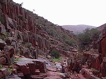
Basaltsäulen in den Gawler Ranges

Die Gawler Ranges, eine Berglandschaft Australiens, liegt im Gawler-Ranges-Nationalpark in South Australia 350 km nordwestlich von Adelaide.

Es handelt sich um eine der ältesten vulkanischen Landschaften der Erde, die, zum Gawler Craton zählend, vor rund 1,5 Milliarden Jahren entstand. Die Berge und Täler erstrecken sich 160 Kilometer ostwestlich im Norden von Eyre Peninsula bis südlich des Lake Gairdner. Der höchste Berg ist der Mount Bluff mit 475 Metern. Entdeckt hat das Bergland Edward John Eyre im Jahre 1839 auf seiner ersten Expedition und benannte es nach dem zweiten Gouverneur von Südaustralien George Gawler (1795-1869).

Die höchsten Berge der Gawler Range sind der Nukey Bluff (457m), Mount Fairview (452m), Paney Hill (449m), Eureka Bluff (431m), Mount Double (428m), Scrubby Peak (428m), Conical Hill (424m), Polturkinna Hill (409m), Kododo Hill (402m), Mount Sturt (392m) und Mount Centre (387m).[1] Die Berge bestehen aus Granit und Basalt. Teilweise sind die Basaltvorkommen säulenförmig ausgebildet. Die Landschaft ist durch semiaride Vegetation mit Buschland, Sanddünen und felsigen Berge und mit der hierfür typischen Flora und Fauna gekennzeichnet. Im Osten, dem sogenannten Middleback Ranges wird seit dem frühen 20. Jahrhundert Eisenerz gewonnen. Im Gebiet der Gawler Ranges befindet sich der Gawler-Ranges-Nationalpark und der Pinkawillinie-Conservation-Park. In diesem Berggebiet befinden sich bedeutsame Kulturstätten der Aborigine, die Yantanabie Historic Reserve und Yardea National Estate, ein Platz mit Zeichen der Ureinwohner Australien auf Porphyr.

Einzelnachweise

  1. Informationen von maps-bonzle

Weblinks


Wikimedia Foundation.

Игры ⚽ Поможем написать курсовую

Schlagen Sie auch in anderen Wörterbüchern nach:

  • Gawler Ranges — The Gawler Ranges are a range of mountains in South Australia to the north of Eyre Peninsula. The Eyre Highway skirts the south of the ranges. The ranges were named by Edward John Eyre after the Governor of South Australia, George Gawler in 1839 …   Wikipedia

  • Gawler Ranges — Chaîne Gawler Chaîne Gawler Géographie Altitude 470 m Massif …   Wikipédia en Français

  • Gawler-Ranges-Nationalpark — Gawler Ranges National Park Kolay Mirica Falls …   Deutsch Wikipedia

  • Gawler Ranges National Park — Infobox protected area of Australia | name = Gawler Ranges National Park iucn category = II caption = locator x = 153 locator y = 161 nearest town or city = Wudinna coordinates = coord|32|33|14|S|135|27|50|E| area = 1,663.03 km² established = 15… …   Wikipedia

  • Gawler Ranges — ▪ mountains, South Australia, Australia       mountains and hills in South Australia, extending 100 miles (160 km) east west across the northern part of Eyre Peninsula, south of Lake Gairdner; they rise in the west as high as 1,550 feet (475… …   Universalium

  • Gawler Ranges — /gɔlə ˈreɪndʒəz/ (say gawluh raynjuhz) plural noun a series of hills in southern SA, south of Lake Gairdner and north of Eyre Peninsula. Highest peak, Scrubby Peak, 472 m. {named after G Gawler1} …  

  • Gawler Ranges National Park — noun a national park in southern SA, north of the Eyre Peninsula, proclaimed in 2002; red volcanic rock and mallee wilderness. 166 000 ha …  

  • Gawler craton — The Gawler Craton covers approximately 440,000 square kilometres of central South Australia. Its Precambrian crystalline basement crustal block was cratonised ca. 1550 1450 Ma. Prior to 1550 Ma the craton comprised a number of active Proterozoic… …   Wikipedia

  • Gawler — ▪ South Australia, Australia       town, South Australia, northeast of Adelaide. It lies at the confluence of the North and South Para rivers (which there form the Gawler River), at the western foot of the Mt. Lofty Ranges. Surveyed in 1839, it… …   Universalium

  • Chaîne Gawler — 32°32′S 135°22′E / 32.533, 135.367 …   Wikipédia en Français

Share the article and excerpts

Direct link
Do a right-click on the link above
and select “Copy Link”