Goodenough Island

Goodenough Island

-9.3666666666667150.266666666677Koordinaten: 9° 22′ S, 150° 16′ O

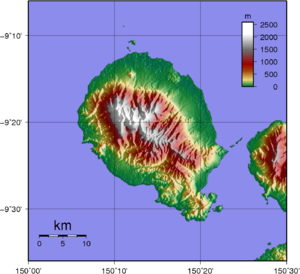
Topografische Karte der Goodenough-Insel.

Die Goodenough-Insel (von den Insulanern Nidula genannt) befindet sich in der Milne-Bay-Provinz von Papua-Neuguinea. Sie liegt östlich des Festlandes in der Salomonensee. Goodenough ist eine der D'Entrecasteaux-Inseln, nahe den Trobriand-Inseln gelegen. Diese Insel wurde 1873 von Kapitän John Moresby besucht, der sie nach Kommodore James Graham Goodenough benannte.

Die Insel ist nahezu kreisförmig. Sie ist 39 Kilometer lang und 26 Kilometer breit. Ihre Fläche beträgt 687 km², die Länge der Küstenlinie 116 Kilometer. Von einem Küstenstreifen, der in der Breite zwischen zwei und zehn Kilometer schwankt, erhebt sich die Insel steil zum 2.536 m hohen Vulkankegel des Mount Vineuo.

Goodenough zählt - gemessen an ihrer Fläche - zu den am steilsten abfallenden Inseln der Welt. Sie ist auch für ihre Felsmalereien, den "Goodenough Island Cargo Cults", bekannt. Im Zweiten Weltkrieg war Goodenough eine wichtige strategische Basis für die Operation Dexterity.

Inhaltsverzeichnis

Dörfer

Folgende Dörfer befinden sich auf der Goodenough-Insel:

  • Vivigani
  • Bolubolu
  • Wailagi
  • Kilia
  • Lauwela
  • Auwale
  • Debenefue
  • Diodio
  • Tatala
  • Waibula
  • Wataluma Mission und Plantage
  • Ulaluya Mission

1980 hatte die Goodenough-Insel 12.676 Bewohner.

Artenschutz

Im Zentrum der Insel befindet sich die Oi Mada Wara Wildlife Management Area. Sie hat eine Gesamtfläche von 22.840 ha. Sie bietet einen kritischen Lebensraum für mehrere gefährdete Tierarten, wie dem Goodenough-Buschkänguru (Dorcopsis atrata) und dem Flinkwallaby (Macropus agilis).

Literatur

  • Jenness M.A. and Rev. A. Ballantyne. (1920) The Northern D'Entrecasteaux, Oxford University Press.

Weblinks


Wikimedia Foundation.

Игры ⚽ Поможем сделать НИР

Schlagen Sie auch in anderen Wörterbüchern nach:

  • Goodenough Island — Infobox Islands name = Goodenough Island image caption = locator Location map|Papua New Guinea|lat= 9.366667|long=150.266667 map custom = yes native name = native name link = location = Melanesia coordinates= coord|9|22|S|150|16|E|type:isle… …   Wikipedia

  • Goodenough Island — ▪ island, Papua New Guinea formerly  Morata        one of the D Entrecasteaux Islands of Papua New Guinea, in the Solomon Sea, southwestern Pacific Ocean. It lies about 20 miles (32 km) across Ward Hunt Strait from the eastern tip of the island… …   Universalium

  • Battle of Goodenough Island — Part of World War II, Pacific War, New Guinea campaign …   Wikipedia

  • Goodenough-Insel — Topografische Karte der Goodenough Insel Gewässer Salomonensee (Pazifischer Ozean) …   Deutsch Wikipedia

  • Goodenough — may refer to any of the following:People*William Goodenough (1867 1945), British admiral *Florence Goodenough (1886 1959), U.S. psychologist *Larry Goodenough (born 1953), Canadian ice hockey player *Ursula Goodenough (born 1943), U.S. biologist… …   Wikipedia

  • Goodenough-Buschkänguru — Systematik Unterklasse: Beutelsäuger (Metatheria) Überordnung: Australidelphia Ordnung: Diprotodontia Familie …   Deutsch Wikipedia

  • Goodenough — 9.3666666666667150.266666666677Koordinaten: 9° 22′ S, 150° 16′ O …   Deutsch Wikipedia

  • Goodenough College — is a postgraduate residence and educational trust on Mecklenburgh Square in Bloomsbury, central London, England. Other names under which the College has been known are London House, William Goodenough House, and the London Goodenough Trust.… …   Wikipedia

  • Fergusson Island — ▪ island, Papua New Guinea       largest of the D Entrecasteaux Islands, Papua New Guinea, in the southwestern Pacific Ocean. The island lies 30 miles (50 km) across Ward Hunt Strait from the southeastern tip of New Guinea, in the Solomon Sea. It …   Universalium

  • Isla Goodenough — Goodenough Island Localización País  Papúa Nueva Guinea Archipiélago Islas d’Entrec …   Wikipedia Español

Share the article and excerpts

Direct link
Do a right-click on the link above
and select “Copy Link”