Hagerman (New Mexico)

Hagerman (New Mexico)
Hagerman
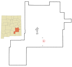
Chaves County New Mexico Incorporated and Unincorporated areas Hagerman Highlighted.svg
Lage in New Mexico
Basisdaten
Staat: Vereinigte Staaten
Bundesstaat: New Mexico
County:

Chaves County

Koordinaten: 33° 7′ N, 104° 20′ W33.112222222222-104.328888888891043Koordinaten: 33° 7′ N, 104° 20′ W
Zeitzone: Mountain Standard Time (UTC−7)
Einwohner: 1168 (Stand: 2000)
Bevölkerungsdichte: 324,4 Einwohner je km²
Fläche: 3,6 km² (ca. 1 mi²)
Höhe: 1043 m
Postleitzahl: 88232
Vorwahl: +1 505
FIPS: 35-31330
GNIS-ID: 0923608

Hagerman ist eine Ortschaft 25 km südlich von Roswell (New Mexico) im Chaves County des US-amerikanischen Bundesstaates New Mexico; von den etwa 1.150 Einwohnern (Stand 2003) sind zwei Drittel lateinamerikanischer Herkunft.

Hagerman entstand 1894 beim Bau der Pecos Valley and Northeaster Railroad am Rande der Trasse; ursprünglich nach dem nahegelegenen Felix River, einem Nebenfluss des Pecos Rivers, Felix genannt, wurde der Ort bald zu Ehren J. J. Hagermans, dem Erbauer der Eisenbahnlinie, umbenannt.

Hagerman liegt an der New Mexico State Route 2.

Persönlichkeiten

In Hagerman geboren wurde:

  • John A. Samford (1905–1968), US-amerikanischer Militär und Direktor des NSA

Wikimedia Foundation.

Игры ⚽ Поможем решить контрольную работу

Schlagen Sie auch in anderen Wörterbüchern nach:

  • Hagerman, New Mexico — Infobox Settlement official name = Hagerman, New Mexico settlement type = Town nickname = motto = imagesize = image caption = image imagesize = image caption = image mapsize = 250px map caption = Location of Hagerman, New Mexico mapsize1 = map… …   Wikipedia

  • New Mexico locations by per capita income — New Mexico has the fifth lowest per capita income in the United States of America, at $17,261 (2000). Its personal per capita income is $25,541 (2003). Contents 1 New Mexico counties ranked by per capita income 2 New Mexico places ranked by Per… …   Wikipedia

  • New Mexico Military Institute — Address 101 West College Blvd. Roswell, New Mexico, Chaves County, 88201 …   Wikipedia

  • New Mexico State Road 2 — NM 2 redirects here. NM 2 may also refer to New Mexico s 2nd congressional district. State Road 2 Route information Maintained by NMDOT …   Wikipedia

  • New Mexico State Route 2 — Basisdaten Gesamtlänge:  32 mi/52 km Anfangspunkt:  …   Deutsch Wikipedia

  • Liste der Highways in New Mexico — Dies ist eine Aufstellung von State Routes, U.S. Highways und Interstates im US Bundesstaat New Mexico, nach Nummern. Inhaltsverzeichnis 1 State Routes 1.1 State Routes 1 bis 300 1.2 State Routes 304 bis 400 …   Deutsch Wikipedia

  • Chaves County (New Mexico) — Verwaltung US Bundesstaat: New Mexico Verwaltungssitz: Roswell Adresse des Verwaltungssitzes: County Courthouse P.O. Box 1817 Roswell, NM 88202 1817 …   Deutsch Wikipedia

  • Dexter, New Mexico —   Town   Location of Dexte …   Wikipedia

  • Liste der State-, U.S.- und Interstate-Highways in New Mexico — Dies ist eine Aufstellung von State Routes, U.S. Highways und Interstates im US Bundesstaat New Mexico, nach Nummern. Inhaltsverzeichnis 1 State Routes 2 United States Highways 2.1 Gegenwärtige Strecken …   Deutsch Wikipedia

  • National Register of Historic Places listings in Chaves County, New Mexico — Location of Chaves County in New Mexico This is a list of the National Register of Historic Places listings in Chaves County, New Mexico. This is intended to be a complete list of the properties and districts on the National Register of Historic… …   Wikipedia

Share the article and excerpts

Direct link
Do a right-click on the link above
and select “Copy Link”