- Hatutu
-
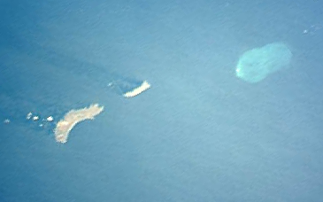
Hatutu (Hatutaʻa) Satellitenbild von Hatutu (Mitte),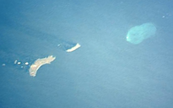
südwestlich liegt Eiao,
nordöstlich liegt Motu OneGewässer Pazifischer Ozean Inselgruppe Marquesas Geographische Lage 7° 55′ 12″ S, 140° 34′ 11″ W-7.92-140.56972222222428Koordinaten: 7° 55′ 12″ S, 140° 34′ 11″ W 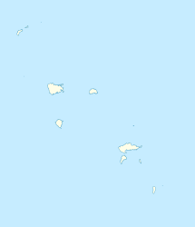

Fläche 6,4 km² Höchste Erhebung (unbenannt)
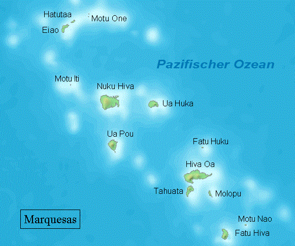
428 mEinwohner (unbewohnt) Karte der Marquesas, Hatutu (Hatutaa) im äußersten Norden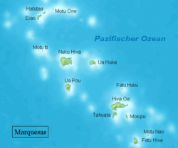
Hatutu, auch Hatutaʻa genannt, ist eine unbewohnte Insel vulkanischen Ursprungs im Pazifischen Ozean. Sie gehört geographisch zur Nordgruppe der Marquesas-Inseln, politisch zu Französisch-Polynesien.
Die 6,4 km² große Insel liegt drei Kilometer östlich von Eiao sowie 19 km westlich von Motu One; ihr höchster Punkt liegt bei 428 m über dem Meeresspiegel. Seit 1992 ist Hatutu ein Naturschutzreservat. Auf der Insel befindet sich ein wichtiges Brutgebiet des Blaufußtölpels (Sula nebouxii).
Entdeckt wurde sie im April 1791 von Joseph Ingraham, der sie einst Hancock Island nannte, nach dem damaligen Gouverneur von Massachusetts John Hancock. Zwei Monate später wurde sie vom Franzosen Étienne Marchand in Chanal umbenannt. 1793 erhielt die Insel den Namen Langdon und 1798 den Namen Nexon.
Schlagen Sie auch in anderen Wörterbüchern nach:
Hatutu — Géographie Pays France Archipel Îles Marquises Localisation Océan Pa … Wikipédia en Français
Hatutu — Infobox Island of French Polynesia name = Hatutu (Hatuta‘a) country = France French Polynesia archipelago = Marquesas Islands region = South Pacific Ocean area = 2.47 sq.mi. 6.4 coastline = peakname = peakheight = 1404 ft 428 population = 0 date… … Wikipedia
Hatutu — Piquero de patas azules (Sula nebouxii). Hatutu, o también Hatuta‘a, es una isla de las Marquesas, en la Polinesia Francesa. Está situada en el grupo norte del archipiélago, a 3 km al noreste de Eiao. Sus coordenadas son … Wikipedia Español
Hatutu Nature Reserve — The Hatutu Nature Reserve is a nature reserve encompassing the whole of the island of Hatutu in the northern Marquesas Islands. The reserve was declared in 1992, and is the primary nesting site of several endangered species, several of which are… … Wikipedia
Hatutaa — Hatutu Hatutu Géographie Pays France Archipel Îles Marquises Localisation Océan Pacifique … Wikipédia en Français
Hatuta'a — w1 Hatutu (Hatutaʻa) Satellitenbild von Hatutu (Mitte) Gewässer Pazifischer Ozean Inselgruppe … Deutsch Wikipedia
Motu One (Marquesas) — Motu One Karte von Motu One Gewässer Pazifischer Ozean Inselgruppe … Deutsch Wikipedia
Marquesas Islands — Marquesas redirects here. For the uninhabited island group in the U.S. State of Florida, see Marquesas Keys. Marquesan redirects here. For the language, see Marquesan language. Coordinates: 9°27′16″S 139°23′20″W / … Wikipedia
Marquesan Nature Reserves — The Marquesan Nature Reserves are a network of small nature reserves in the Marquesas Islands. The reserves were declared by the government of French Polynesia in 1992, as a first step toward preserving the native flora and fauna of some of the… … Wikipedia
Hatutaa Polynesian Warbler — Taxobox name = Hatutaa Polynesian Warbler regnum = Animalia phylum = Chordata classis = Aves ordo = Passeriformes familia = Sylviidae genus = Acrocephalus species = A. caffer subspecies = A. c. postremus trinomial = Acrocephalus caffer postremus… … Wikipedia
Hatutu

18+
© Academic, 2000-2026
- Kontaktieren Sie uns: Unterstützung, Werbung
Wörterbücher Export, schritte mit PHP, Joomla, Drupal, WordPress, MODx.