- Alma (New Brunswick)
-
Alma 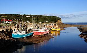
Hafen von Alma beim Einsetzen der FlutStaat: Kanada Provinz: New Brunswick County: Albert County Koordinaten: 45° 36′ N, 64° 57′ W45.601944444444-64.943333333333Koordinaten: 45° 36′ N, 64° 57′ W Fläche: 47,64 km² Einwohner: 301 (Stand: 2006) Bevölkerungsdichte: 6,3 Einw./km² Zeitzone: Atlantic Time (UTC−4) Bürgermeister: Hilyard Rossiter Webpräsenz: www.villageofalma.ca/ Alma ist ein Fischerdorf im Albert County in der kanadischen Provinz New Brunswick. Alma hat 301 Einwohner auf einer Fläche von 47,64 km² (Stand 2006).[1] Die Bevölkerungsdichte liegt bei 6,3 Einwohner/km².[1] Alma liegt an der Mündung des Upper Salomon River in die Bay of Fundy. Das Dorf liegt am Eingang zum Fundy-Nationalpark, deren Dorfbewohner leben hauptsächlich von der Fischerei.
Weblinks
 Commons: Alma (New Brunswick) – Sammlung von Bildern, Videos und Audiodateien
Einzelnachweis
- ↑ a b Community Profiles from the 2006 Census, Statistics Canada. www.statcan.gc.ca, abgerufen am 2. März 2009 (englisch).
Kategorie:- Ort in New Brunswick

Wikimedia Foundation.