- Inangahua River
-
Inangahua River 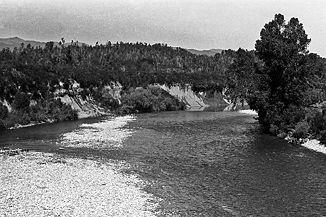
Mittellauf des Inangahua
Daten Lage Südinsel, Neuseeland Flusssystem Buller River Mündung in den Buller River -41.85171.94333333333Koordinaten: 41° 51′ 0″ S, 171° 56′ 36″ O
41° 51′ 0″ S, 171° 56′ 36″ O-41.85171.94333333333Länge 70 km Mittelstädte Reefton Der Inangahua River ist ein Fluss auf der Südinsel Neuseelands. Er gilt als der größte Zufluss des Buller River.
Der Fluss ist ein beliebtes Revier für Wildwasserkayakfahren und Angeln.
Weblinks
Kategorien:- Flusssystem Buller River
- Fluss in Neuseeland
- Fluss in Australien und Ozeanien
- West Coast (Region)

Wikimedia Foundation.