- Independence Rock
-
Independence Rock National Register of Historic Places National Historic Landmark 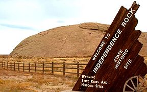
Independence Rock

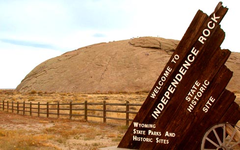
Lage Natrona County, Wyoming Koordinaten 42° 29′ 37″ N, 107° 7′ 46″ W42.493611111111-107.12944444444Koordinaten: 42° 29′ 37″ N, 107° 7′ 46″ W NRHP-Nummer 66000757 Daten Ins NRHP aufgenommen 15. Oktober 1966 Als NHL deklariert 20. Januar 1961 Der Independence Rock [ˌɪndɪˈpendəns rɑk] (deutsch Unabhängigkeitsfelsen) ist ein etwa 36 Meter hoher Granitfelsen am Ufer des Sweetwater River im Südwesten von Natrona County im US-Bundesstaat Wyoming. Mitte des 19. Jahrhunderts war der Felsen ein sehr beliebter und berühmter Treffpunkt für Immigranten, die über den Oregon Trail in den Westen der USA wollten. Die Siedler feierten dort den amerikanischen Unabhängigkeitstag, da sie meist am oder um den 4. Juli daran vorbeikamen. Es wurde zum Brauch, dort seinen Namen sowie das Datum seines Besuchs und einen kleinen Spruch für die Nachwelt einzumeißeln.
Der Independence Rock wurde 1961 zu einem nationalen historischen Wahrzeichen (National Historic Landmark) erklärt.
Siehe auch
- Register Cliff
- Names Hill
Weblinks
- National Park Service: Independence Rock in der Datenbank für National Historic Landmarks (Englisch)
- Independence Rock im Geographic Names Information System des United States Geological Survey

National Historic Landmark: Expedition Island | Fort Phil Kearny and Associated Sites | Fort Yellowstone | Heart Mountain Relocation Center | Horner Site | Independence Rock | Jackson Lake Lodge | Medicine Wheel | Norris, Madison, and Fishing Bridge Museums | Obsidian Cliff | Old Faithful Inn | Oregon Trail Ruts | Sheridan Inn | South Pass | Tom Sun Ranch | Swan Land and Cattle Company Headquarters | Union Pacific Railroad Depot | Upper Green River Rendezvous Site | Wapiti Ranger Station | Wyoming State Capitol
National Historic Landmark District: Fort D.A. Russell | Lake Guernsey State Park | Murie Ranch Historic District | J. C. Penney Historic District
Wikimedia Foundation.
Schlagen Sie auch in anderen Wörterbüchern nach:
Independence rock — Independence Rock est un rocher de granit d environ 36 mètres, situé au sud ouest du Comté de Natrona, dans le Wyoming, aux États Unis d Amérique. Situé sur la Piste de l Oregon et sur la Piste des Mormons, ce lieu est classé à l inventaire du N … Wikipédia en Français
Independence Rock — may refer to:*Independence Rock (Wyoming) , a well known landmark on the Oregon Trail *Independence Rock (Oregon) … Wikipedia
Independence Rock — 42° 29′ 37″ N 107° 07′ 44″ W / 42.4936, 107.129 … Wikipédia en Français
Independence Rock (Wyoming) — Independence Rock Independence rock Independence Rock est un rocher de granit d environ 36 mètres, situé au sud ouest du Comté de Natrona, dans le Wyoming, aux États Unis d Amérique. Situé sur la Piste de l Oregon et sur la Piste des Mormons, ce… … Wikipédia en Français
Independence Rock (Wyoming) — Infobox nrhp name = Independence Rock nrhp type = nhl caption = Independence Rock location = 60 mi. SW of Casper on WYO 220 nearest city = lat degrees = lat minutes = lat seconds = lat direction = long degrees = long minutes = long seconds = long … Wikipedia
Rock formations in the United States — The following is a partial list of rock formations in the United States, by state: Arizona*Peralta Canyon, Phoenix *Red Rock Country, Sedona California*Alabama Hills *Castle Crags *El Capitan *Half Dome *Indian Rock, Indian Rock Park *Nine… … Wikipedia
Independence (álbum) — Independence Álbum de Sex Museum Publicación 1989 Grabación septiembre de 1989 Género(s) Hard rock Garage rock Durac … Wikipedia Español
Independence Public School District — is a school district headquartered in Independence, Missouri, United States. The district serves most of Independence and Sugar Creek. Superintendent As of 2008 the Superintendent of Schools in the Independence Public School District is Dr. Jim… … Wikipedia
Independence High School — may refer to: *Independence High School (Glendale, Arizona) in Glendale, Arizona *Independence High School (Alhambra, California) in Alhambra, California *Independence High School (Brentwood, California) in Brentwood, California *Independence… … Wikipedia
Independence of irrelevant alternatives — (IIA) is an axiom of decision theory and various social sciences. The word is used in different meanings in different contexts. Although they all attempt to provide a rational account of individual behavior or aggregation of individual… … Wikipedia
Independence Rock

18+
© Academic, 2000-2026
- Kontaktieren Sie uns: Unterstützung, Werbung
Wörterbücher Export, schritte mit PHP, Joomla, Drupal, WordPress, MODx.