Itbayat

Itbayat
Municipality of Itbayat
Lage von Itbayat in der Provinz Batanes
Karte
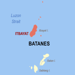
Basisdaten
Bezirk: Cagayan Valley
Provinz: Batanes
Barangays: 5
Distrikt: 1. Distrikt von Batanes
PSGC: 020902000
Einkommensklasse: 5. Einkommensklasse
Haushalte: 719
Zensus 1. Mai 2000
Einwohnerzahl: 3.069
Zensus 1. August 2007
Bevölkerungsdichte: 36,9 Einwohner je km²
Fläche: 83,13 km²
Koordinaten: 20° 47′ N, 121° 50′ O20.785555555556121.83527777778Koordinaten: 20° 47′ N, 121° 50′ O
Postleitzahl: 3905
Geographische Lage auf den Philippinen
Itbayat (Philippinen)
Itbayat
Itbayat

Itbayat ist die nördlichste philippinische Stadtgemeinde. Sie gehört zur Provinz Batanes. Im Jahr 2000 hatte die Gemeinde 3616 Einwohner und 719 Haushalte. Zu Itbayat gehören außer der gleichnamigen Hauptinsel noch weitere fünf benannte Inseln, die mit einer Ausnahme alle nördlich von der Hauptinsel liegen und deshalb die nördlichsten Inseln der Philippinen sind, sowie einige kleine unbenannte Nebeninseln und Felsen. Die Inseln von Nord nach Süd:

  • Y'Ami Island
  • North Island
  • Mabudis
  • Maysanga (Misanga)
  • Siayan (Stayan)

Barangays

Die Gemeinde Itbayat gliedert sich in fünf Baranggays (Bevölkerung zur Volkszählung 2000 in Klammern[1]

  • Raele (Süden) (480)
  • San Rafael (Idiang) (Westen) (754)
  • Santa Lucia (Kauhauhasan) (Osten) (737)
  • Santa Maria (Marapuy) (Nordosten) (601)
  • Santa Rosa (Kaynatuan) (Nordwesten) (1044)

Einzelnachweise

  1. Region II - Cagayan Valley

Weblinks


Wikimedia Foundation.

Игры ⚽ Поможем сделать НИР

Schlagen Sie auch in anderen Wörterbüchern nach:

  • Itbayat — 20°47′N 121°51′E / 20.783, 121.85 …   Wikipédia en Français

  • Itbayat — Original name in latin Itbayat Name in other language Itabayat, Itbayat, Mayan State code PH Continent/City Asia/Manila longitude 20.78733 latitude 121.84178 altitude 91 Population 0 Date 2011 07 31 …   Cities with a population over 1000 database

  • Itbayat (Batanes) — Itbayat Carte de Batanes avec localisation de Itbayat Itbayat est une municipalité de province de Batanes, aux Philippines. Voir aussi Listes des villes des Philippines par province …   Wikipédia en Français

  • Itbayat Island — Itbayat is one of the Batanes Islands of the Philippines. Together with some other islands it forms the municipality of Itbayat in Batanes Province.The major produce of the island are garlic, pineapple, and coconut trees. Itbayat is also home to… …   Wikipedia

  • Itbayat (Stadt) — Municipality of Itbayat Lage von Itbayat in der Provinz Batanes Basisdaten Bezirk: Cagayan Valley …   Deutsch Wikipedia

  • Itbayat, Batanes — The island municipality of Itbayat is the largest of the three inhabited islands that compose the province of Batanes. It is also the northernmost municipality in the Philippines, located only over 200 kilometers from the southernmost tip of… …   Wikipedia

  • Batanes — Infobox Philippine province name = Batanes sealfile = Ph seal batanes.png region = Cagayan Valley (Region II) capital = Basco founded = mdash; pop2000 = 16,467 pop2000rank = smallest popden2000 = 79 popden2000rank = 11th lowest areakm2 = 209.3… …   Wikipedia

  • Ivatan language — language name=Ivatan/ Ibatan nativename=Chirin nu Ibatan familycolor=Austronesian states=Philippines region=Batanes Islands speakers=35,000 (Population includes 3,448 Itbayatan) fam2=Malayo Polynesian fam3=Borneo Philippines fam4=Northern… …   Wikipedia

  • Batan-Inseln — Lage der Provinz Batanes ist die nördlichste und kleinste Provinz der Philippinen. Zur Provinz gehört die beinahe gleichnamige Inselgruppe der Batan Inseln. Die Hauptstadt der Provinz ist Basco. Insgesamt leben 15.974 Einwohner (Zensus 1. August… …   Deutsch Wikipedia

  • PH-BTN — Lage der Provinz Batanes ist die nördlichste und kleinste Provinz der Philippinen. Zur Provinz gehört die beinahe gleichnamige Inselgruppe der Batan Inseln. Die Hauptstadt der Provinz ist Basco. Insgesamt leben 15.974 Einwohner (Zensus 1. August… …   Deutsch Wikipedia

Share the article and excerpts

Direct link
Do a right-click on the link above
and select “Copy Link”