Jeitun

Jeitun
38.10326758.207401
Jeitun (Turkmenistan)
Jeitun
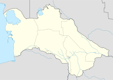
Jeitun

Jeitun (deutsch auch Dscheitun) ist ein Ausgrabungsort im südlichen Turkmenistan, etwa 30 Kilometer nordwestlich von Aşgabat im Kopet-Dag-Gebirge. Er gilt als ältester Beleg für ackerbautreibende Kulturen in Zentralasien: der Anbau einer primitiven Weizensorte gilt als gesichert.

Das Dorf besteht aus etwa drei Dutzend Häusern aus sonnengetrockneten Lehmblöcken. Die Funde werden der Jungsteinzeit zugeordnet und reichen bis ins 7. Jahrtausend v. Chr. zurück. Funde wie steinerne Handmühlen, dekorierte Keramik und Werkzeuge lassen vermuten, dass bereits Spezialisten am Werk waren. Tierknochenfunde weisen auf eine bereits stattgefundene Domestikation des Schafes hin.

Jeitun wurde 1957 von V. M. Masson wiederentdeckt und ausgegraben.

Weblink


Wikimedia Foundation.

Игры ⚽ Поможем сделать НИР

Schlagen Sie auch in anderen Wörterbüchern nach:

  • Dscheitun — Jeitun (deutsch auch Dscheitun) ist ein Ausgrabungsort im südlichen Turkmenistan, etwa 30 Kilometer nördwestlich von Aşgabat im Kopet Dag Gebirge. Er gilt als ältester Beleg für ackerbautreibende Kulturen in Zentralasien: der Anbau einer… …   Deutsch Wikipedia

  • Bactria–Margiana Archaeological Complex — The extent of the BMAC (after EIEC). The Bactria–Margiana Archaeological Complex (or BMAC, also known as the Oxus civilization) is the modern archaeological designation for a Bronze Age culture of Central Asia, dated to ca. 2300–1700 BC, located… …   Wikipedia

  • David R. Harris — David Russell Harris (born 14 December 1930[1]) is a British geographer, anthropologist, archaeologist and academic, well known for his detailed work on the origins of agriculture and the domestication of plants and animals.[2] He is a former… …   Wikipedia

  • Turkmenistan — /terrk me neuh stan , stahn /, n. a republic in central in Asia, bordering the Caspian Sea, Iran, and Afghanistan. 4,225,351; 188,417 sq. mi. (488,000 sq. km). Cap.: Ashkhabad. Also called Turkomen. Formerly, Turkmen Soviet Socialist Republic. *… …   Universalium

  • Nostratic languages — Nostratic (controversial) Geographic distribution: Europe, Asia except for the southeast, North and Northeast Africa, the Arctic Linguistic classification: Borean (?) …   Wikipedia

  • Histoire De L'Iran — Les frontières actuelles de l Iran …   Wikipédia en Français

  • Histoire de l'Iran — Les frontières actuelles de l Iran. Le roi des rois …   Wikipédia en Français

  • Histoire de l'iran — Les frontières actuelles de l Iran …   Wikipédia en Français

  • Histoire de l’Iran — Histoire de l Iran Les frontières actuelles de l Iran …   Wikipédia en Français

  • Kopet-Dag — 38°00′N 57°20′E / 38, 57.333 …   Wikipédia en Français

Share the article and excerpts

Direct link
Do a right-click on the link above
and select “Copy Link”