Amphoe Mae Lan

Amphoe Mae Lan
Mae Lan
แม่ลาน
Provinz: Pattani
Fläche: 89,2 km²
Einwohner: 14.863 (2005)
Bev.dichte: 166,6 E./km²
PLZ: 94180
Geocode: 9411
Karte
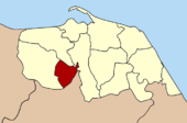
Karte von Pattani, Thailand mit Mae Lan

Amphoe Mae Lan (Thai: อำเภอ แม่ลาน) ist ein Landkreis (Amphoe - Verwaltungs-Distrikt) in der Provinz Pattani. Die Provinz Pattani liegt im Südosten der Südregion von Thailand am Golf von Thailand.

Inhaltsverzeichnis

Geographie

Benachbarte Landkreise und Gebiete sind (von Westen im Uhrzeigersinn): die Amphoe Khok Pho, Nong Chik und Yarang in der Provinz Pattani sowie Amphoe Mueang Yala in der Provinz Yala.

Geschichte

Mae Lan wurde am 1. April 1989 zunächst als Unterbezirk (King Amphoe) eingerichtet, indem drei Tambon vom Amphoe Khok Pho abgetrennt wurden. [1] Am 7. September 1995 bekam Mae Lan den vollen Amphoe-Status. [2]

Verwaltung

Amphoe Mae Lan ist in drei Unterbezirke (Tambon) eingeteilt, welche weiter in 22 Dorfgemeinschaften (Muban) unterteilt sind.

Außerdem gibt es drei „Tambon Administrative Organizations“ (TAO, องค์การบริหารส่วนตำบล – Verwaltungs-Organisationen) im Landkreis.

Nr. Name Thai Dörfer Einw.
1. Mae Lan แม่ลาน 8 3.682
2. Muang Tia ม่วงเตี้ย 9 5.436
3. Pa Rai ป่าไร่ 10 5.745

Einzelnachweise

  1. ประกาศกระทรวงมหาดไทย เรื่อง แบ่งท้องที่อำเภอโคกโพธิ์ จังหวัดปัตตานี ตั้งเป็นกิ่งอำเภอแม่ลาน Royal Gazette, Band 106, Ausg. 40 ง vom 14. März 1989, S. 1888 (in Thai)
  2. พระราชกฤษฎีกาตั้งอำเภอด่านมะขามเตี้ย อำเภอแก่งหางแมว อำเภอภักดีชุมพล อำเภอเวียงแก่น อำเภอแม่วาง อำเภอถ้ำพรรณรา อำเภอบ่อเกลือ อำเภอโนนสุวรรณ อำเภอห้วยราช อำเภอแม่ลาน อำเภอบางแก้ว อำเภอป่าพะยอม อำเภอหนองม่วงไข่ อำเภอยางสีสุราช อำเภอจังหาร อำเภอบ้านธิ อำเภอภูสิงห์ อำเภอบางกล่ำ อำเภอวังม่วง และอำเภอนายูง พ.ศ. ๒๕๓๘ Royal Gazette, Band 112, Ausg. 32 ก vom 8. August 1995, S. 1-3 (in Thai=

Weblinks


Wikimedia Foundation.

Игры ⚽ Поможем решить контрольную работу

Schlagen Sie auch in anderen Wörterbüchern nach:

  • Amphoe Mae Lan — Infobox Amphoe name=Mae Lan thai=แม่ลาน province=Pattani coordinates=coord|6|39|39|N|101|14|23|E|type:adm2nd region:TH capital=Mae Lan area=89.2 population= 14,863 population as of=2005 density=166.6 postal code=94180 geocode=9411Mae Lan ( th.… …   Wikipedia

  • Amphoe Mae Lan — Admin ASC 2 Code Orig. name Amphoe Mae Lan Country and Admin Code TH.69.8304631 TH …   World countries Adminstrative division ASC I-II

  • Mae Lan District — Mae Lan แม่ลาน   Amphoe   Amphoe location in Pattani Province …   Wikipedia

  • Mae Lan — Original name in latin Mae Lan Name in other language Amphoe Mae Lan, Ban Mae Lan, Ban Mehlan, King Amphoe Mae Lan, Mae Lan, Mae Ran State code TH Continent/City Asia/Bangkok longitude 6.66114 latitude 101.23958 altitude 13 Population 0 Date 2012 …   Cities with a population over 1000 database

  • Amphoe Mae Charim — Mae Charim แม่จริม Provinz: Nan Fläche: 998,152 km² Einwohner: 15.794 (2005) Bev.dichte: 15,8 E./km² PLZ: 55170 …   Deutsch Wikipedia

  • Amphoe Mae Poen — Mae Poen แม่เปิน Provinz: Nakhon Sawan Fläche: 260,2 km² Einwohner: 19.730 (2005) Bev.dichte: 75,8 E./km² PLZ: 60150 …   Deutsch Wikipedia

  • Mae Lan, Lamphun —   Tambon   Country  Thailand Province …   Wikipedia

  • Amphoe Mae Poen — Infobox Amphoe thai=แม่เปิน name=Mae Poen province=Nakhon Sawan coordinates=coord|15|39|28|N|99|28|9|E|type:adm2nd region:TH capital=Mae Poen area=260.2 population=19,730 population as of=2005 density=75.8 postal code=60150 geocode=6014Mae Poen ( …   Wikipedia

  • Amphoe Khok Pho — Khok Pho โคกโพธิ์ Provinz: Pattani Fläche: 64.329 km² Einwohner: 83.770 (2005) Bev.dichte: 189,5 E./km² PLZ: 94120 …   Deutsch Wikipedia

  • Amphoe Yarang — Yarang ยะรัง Provinz: Pattani Fläche: 184,0 km² Einwohner: 83.770 (2005) Bev.dichte: 455,2 E./km² PLZ: 94160 …   Deutsch Wikipedia

Share the article and excerpts

Direct link
Do a right-click on the link above
and select “Copy Link”