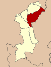
- Amphoe Mae Tha (Lamphun)
-
Mae Tha
แม่ทาProvinz: Lamphun Fläche: 762,6 km² Einwohner: 40.361 (2005) Bev.dichte: 52,9 E./km² PLZ: 51140 Geocode: 5102 Karte 
Amphoe Mae Tha (Thai อำเภอ แม่ทา) ist ein Landkreis (Amphoe - Verwaltungs-Distrikt) im Nordosten der Provinz Lamphun. Die Provinz Lamphun liegt in der Nordregion von Thailand.
Inhaltsverzeichnis
Geographie
Benachbarte Landkreise (von Süden im Uhrzeigersinn): die Amphoe Thung Hua Chang, Ban Hong, Pa Sang und Mueang Lamphun der Provinz Lamphun, Mae On der Provinz Chiang Mai, sowie Mueang Lampang, Hang Chat und Soem Ngam der Provinz Lampang.
Ein Teil des Nationalparks Doi Khun Tan (Thai: อุทยานแห่งชาติดอยขุนตาล) liegt im Landkreis Mae Tha, der größere Teil befindet ich im westlichen Teil der Provinz Lampang. Der 255 km² große Park wurde bereits 1975 als zehnter Nationalpark von Thailand eröffnet.
Geschichte
Mae Tha wurde im Jahr 1939 als Unterbezirk (King Amphoe) gegründet, bestehend aus Tambon, die vom Kreis Mueang Lamphun abgespalten wurden. Am 22. Juli 1958 erhielt der Unterbezirk den vollen Amphoe-Status.[1]
Verwaltung
Der Kreis ist in sechs Kommunen (Tambon) eingeteilt, welche sich weiter in 68 Dörfer (Muban) unterteilen.
Es gibt zwei Kleinstädte (Thesaban Tambon) im Bezirk:
- Tha Sop Sao besteht aus Teilen des gleichnamigen Tambon.
- Tha Kat besteht aus Teilen der Tambon Tha Kat und Tha Khum Ngoen.
Außerdem gibt es sechs „Tambon Administrative Organizations“ (TAO, องค์การบริหารส่วนตำบล - Verwaltungs-Organisationen).
Nr. Name Thai Dörfer Einw. 1. Tha Pla Duk ทาปลาดุก 14 7.594 2. Tha Sop Sao ทาสบเส้า 16 10.883 3. Tha Kat ทากาศ 15 8.004 4. Tha Khum Ngoen ทาขุมเงิน 11 6.858 5. Tha Thung Luang ทาทุ่งหลวง 6 3.990 6. Tha Mae Lop ทาแม่ลอบ 6 3.032 Einzelnachweise
- ↑ พระราชกฤษฎีกาจัดตั้งอำเภอกระสัง อำเภอกระนวน อำเภอบางกอกใหญ่ อำเภอขุนหาร อำเภอพนา อำเภอปากช่อง อำเภอวังเหนือ อำเภอวังชิ้น อำเภอแม่ทา อำเภอหนองหมู อำเภอสระแก้ว อำเภออมก๋อย อำเภอบางซ้าย อำเภอทับสะแก อำเภอบุณฑริก อำเภอลานสะกา อำเภอจอมบึง อำเภอท่ายาง อำเภอสามเงา อำเภอฟากท่า อำเภอบ้านเขว้า อำเภอชานุมาน อำเภอแม่พริก อำเภอท่าสองยาง อำเภอสะเมิง อำเภอหนองแขม อำเภอพระแสง พ.ศ. ๒๕๐๑. In: Royal Gazette. 75, Nr. 55 ก, 22. Juli 1958, S. 321-327.
Weblinks
- Weitere Informationen zum Amphoe Mae Tha von amphoe.com (in Thai)
- Offizielle Seite des Nationalparks Doi Khun Tan (in Englisch)
Mueang Lamphun | Mae Tha | Ban Hong | Li | Thung Hua Chang | Pa Sang | Ban Thi | Wiang Nong Long
Wikimedia Foundation.
Schlagen Sie auch in anderen Wörterbüchern nach:
Amphoe Mae Tha, Lamphun Province — Infobox Amphoe name=Mae Tha thai=แม่ทา province=Lamphun coordinates=coord|18|27|43|N|99|8|5|E|type:admin2md region:TH capital=Tha Sop Sao area=762.6 population=40,361 population as of=2005 density=52.9 postal code=51140 geocode=5102Mae Tha ( th.… … Wikipedia
Amphoe Mae Tha — steht für einen Landkreis (Amphoe) in Thailand. Es gibt zwei verschiedene Landkreise Mae Tha, deren thailändische Schrift sich jedoch unterscheidet: Amphoe Mae Tha (Lampang) (อำเภอ แม่ทะ) Amphoe Mae Tha (Lamphun) (อำเภอ แม่ทา) … Deutsch Wikipedia
Amphoe Mae Tha — The are two amphoe named Mae Tha in Thailand, which, however, have two different Thai spellings *Amphoe Mae Tha, Lampang Province (แม่ทะ) *Amphoe Mae Tha, Lamphun Province (แม่ทา) … Wikipedia
Mae Tha — bezeichnet: Amphoe Mae Tha (Lampang), einen Landkreis der nordthailändischen Provinz Lampang Amphoe Mae Tha (Lamphun), einen Landkreis der nordthailändischen Provinz Lamphun Diese Seite ist eine Begriffsklärung zur Unterscheid … Deutsch Wikipedia
Mae Tha District, Lamphun — Mae Tha แม่ทา Amphoe Amphoe location in Lamphun Province … Wikipedia
Amphoe Mae On — Mae On แม่ออน Provinz: Chiang Mai Fläche: 442,3 km² Einwohner: 21.652 (2005) Bev.dichte: 49,0 E./km² PLZ: 50130 … Deutsch Wikipedia
Amphoe Mae Phrik — Mae Phrik แม่พริก Provinz: Lampang Fläche: 538,9 km² Einwohner: 17.153 (2005) Bev.dichte: 31,8 E./km² PLZ: 52180 … Deutsch Wikipedia
Amphoe Mae On — Infobox Amphoe name=Mae On thai=แม่ออน province=Chiang Mai coordinates=coord|18|46|35|N|99|14|53|E|type:adm2nd region:TH capital=On Klang area=442.3 population=21,652 population as of=2005 postal code=50130 density=49.0 geocode=5023Mae On is a… … Wikipedia
Mae On — แม่ออน Provinz: Chiang Mai Fläche: 442,3 km² Einwohner: 21.652 (2005) Bev.dichte: 49,0 E./km² PLZ: 50130 … Deutsch Wikipedia
Mae Phrik — แม่พริก Provinz: Lampang Fläche: 538,9 km² Einwohner: 17.153 (2005) Bev.dichte: 31,8 E./km² PLZ: 52180 … Deutsch Wikipedia

