- Joinville Island
-
Joinville Island Gewässer Südlicher Ozean Inselgruppe Joinville-Inseln Geographische Lage 63° 15′ S, 55° 45′ W-63.25-55.75825Koordinaten: 63° 15′ S, 55° 45′ W 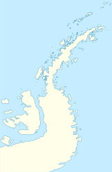

Länge 64 km Breite 20 km Fläche 1.607,4 km² Höchste Erhebung Mount Tholus
825 mEinwohner (unbewohnt) Eine Karte von Grahamland mit Joinville Island (4)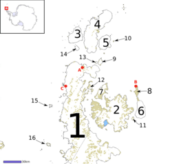
Joinville Island (französisch Île Joinville) ist die größte der Joinville-Inseln. Gelegen vor der nordöstlichen Spitze der Antarktischen Halbinsel, von der sie durch den Antarctic Sound getrennt ist, ist sie in Ost-West-Richtung etwa 64 Kilometer lang und 20 Kilometer breit. Sie weist dabei eine Fläche von 1607 km² auf. Die Insel wurde 1838 von einer französischen Expedition unter Jules Dumont d'Urville entdeckt, grob kartiert und nach François Ferdinand Philippe Louis Marie, Prince de Joinville (1818-1900), dem dritten Sohn des Duc d'Orléans Ludwig Philipp von Frankreich benannt.
Der höchste Berg der Insel ist Mount Tholus, mit einer Höhe von 825 Metern[1], nach anderen Angaben sogar 1112 Metern.[2] 10,5 km nördlich davon steht Mount Percy, der nach beiden Quellen übereinstimmend 765 Meter hoch ist und in ersterer fälschlich als höchster Berg von Joinville Island bezeichnet wird.[3]
Auf Joinville Island befindet sich die gleichnamige von Brasilien betriebene automatische Wetterstation.[4]
Weblinks
- Joinville Island im Australian Antarctic Data Centre (englisch)
Einzelnachweise
- ↑ USGS Geographic Names Information System (GNIS), Antarctica ID: 15189, Tholus, Mount
- ↑ Sailing Directions (enroute), Pub. 200: 1.47 Joinville Island
- ↑ USGS Geographic Names Information System (GNIS), Antarctica ID: 15189, Percy, Mount
- ↑ [1]
Inseln der Joinville-InselnBransfield Island | Dundee Island | Île d’Urville | Île Joinville | Paulet Island
Wikimedia Foundation.
Schlagen Sie auch in anderen Wörterbüchern nach:
Joinville Island — Infobox Islands name = Joinville image caption = Map of Graham Land, showing Joinville Island (4) image size = 250px locator map custom = nickname = location = Antarctica coordinates = coord|63|15|S|55|45|W|display=inline archipelago = Joinville… … Wikipedia
Joinville Island group — is a group of sub antarctic islands, lying off the northeastern tip of the Antarctic Peninsula, from which Joinville Island group is separated by the Antarctic Sound. Joinville Island, being located at coord|63|15|S|55|45|W|, is the largest… … Wikipedia
Joinville (disambiguation) — Joinville can refer to Jean de Joinville (1224 December 24 1319), one of the great chroniclers of medieval France. It also refers to the Prince de JoinvilleJoinville (pronunciation: ZHWEN veel) is also the name of these cities:*In Brazil:… … Wikipedia
Joinville — ist der Name folgender geographischer Objekte: Joinville (Brasilien), Stadt im Bundesstaat Santa Catarina Joinville (Haute Marne), Gemeinde im französischen Département Haute Marne Joinville le Pont, Stadt im französischen Département Val de… … Deutsch Wikipedia
Joinville-Inselgruppe — Die Gruppe der Joinville Inseln: * D Urville Island (3) * Joinville Island (4) * Dundee Island (5) Die Gruppe der Joinville Inseln ist eine Gruppe von subantarktischen Inseln, die vor dem nordöstlichen Zipfel der Antarktischen Halbinsel liegen,… … Deutsch Wikipedia
Joinville-Insel — Karte von Grahamland mit der Joinville Insel (4) Joinville Island ist die größte der Joinville Inseln. Gelegen vor der nordöstlichen Spitze der Antarktischen Halbinsel, von der sie durch den Antarctic Sound getrennt ist, ist sie in Ost West… … Deutsch Wikipedia
Joinville-Inseln — Gewässer Südlicher Ozean Geographische Lage 6 … Deutsch Wikipedia
D’Urville Island (Antarktis) — Vorlage:Infobox Insel/Wartung/Bild fehlt D’Urville Island Gewässer Südlicher Ozean Inselgruppe Joinville Inseln Geographische Lage … Deutsch Wikipedia
D'Urville Island, Antarctica — Map of Graham Land, showing D Urville Island (3) Geography Location Antarctica Coordinates … Wikipedia
D'Urville Island (Antarktis) — Eine Karte von Grahamland mit D Urville Island (3) D Urville Island ist eine subantarktische Insel. Sie ist die nördlichste der dem Grahamland vorgelagerten Joinville Inseln und 27 Kilometer lang. Sie liegt unmittelbar nördlich von Joinville… … Deutsch Wikipedia
Joinville Island


![[1]](http://amrc.ssec.wisc.edu/aws/images/2010_AWS_Sites_ALL_04_12_2011-Final.jpg)
18+
© Academic, 2000-2026
- Kontaktieren Sie uns: Unterstützung, Werbung
Wörterbücher Export, schritte mit PHP, Joomla, Drupal, WordPress, MODx.