Kokoda-Trail

Kokoda-Trail
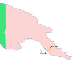
Lage des Kokoda-Track

Der Kokoda Track ist ein heute touristisch genutzter Buschpfad zwischen den Yodda Kokoda Goldfeldern und der Südküste von Papua-Neuguinea. Er führt von Kokoda über das Owen-Stanley-Gebirge zur Papua-Neuguineischen Hauptstadt Port Moresby.

In das Blickfeld der Weltöffentlichkeit rückte er 1942, als die japanische Armee letztendlich erfolglos über den Track auf Port Moresby zumarschierte. Der Track ist heute eine der bekanntesten Touristenattraktionen Papua-Neuguineas. Er führt auf 2.190 Höhenmeter hinauf und durch einige schöne Regenwälder und lässt sich in 5 bis 6 Tagen erwandern.

Geschichte

Goldgräber-Track

Der Kokoda Track verbindet die Nord- und die Südküste Papua-Neuguineas miteinander. Zuerst wurde er von Abenteurern benutzt, die über ihn die Yodda Kokoda Goldfelder erreichten.

Im 2. Weltkrieg

Nach ihrem Angriff auf Pearl Harbour im Dezember 1941 rückten die Japaner rasant über den Pazifik auf Australien zu. Der Vorstoß der japanischen Marine auf Port Moresby wurde in der Schlacht im Korallenmeer gestoppt, was zu einem anderen Vorstoßplan führte. Über den Kokoda Track sollte die Armee nach Port Moresby marschieren. Am 21. Juli 1942 landeten die Japaner und überrannten die australische Verteidigung entlang des Tracks. Die australische Armee-Führung hatte bereits eine letzte Abwehrschlacht unmittelbar vor Port Moresby geplant, als der japanische Vormarsch am 16. September bei Ioribaiwa, in Sichtweite Port Moresbys, stoppte. Pläne, den Track für Fahrzeuge benutzbar auszubauen, hatten sich als undurchführbar erwiesen und die Versorgung der Soldaten über Luft war kaum ausreichend. Gleichzeitig geriet die japanische Armee bei Guadalcanal auf den Salomonen unter Druck, so dass sich die Truppen auf dem Kokoda Track zurückzogen.

In der anschließenden Buna Campaign, die die Japaner von der Nordküste vertrieb, standen sich japanische und australische Truppen das letzte Mal direkt gegenüber.


Wikimedia Foundation.

Игры ⚽ Поможем написать реферат

Schlagen Sie auch in anderen Wörterbüchern nach:

  • Kokoda Trail — Lage des Kokoda Track Der Kokoda Track ist ein heute touristisch genutzter Buschpfad zwischen den Yodda Kokoda Goldfeldern und der Südküste von Papua Neuguinea. Er führt von Kokoda über das Owen Stanley Gebirge zur Papua Neuguineischen Hauptstadt …   Deutsch Wikipedia

  • Kokoda Track — For the World War II battle, see Kokoda Track campaign. The Kokoda Trail Length 96 kilometres (60 mi) Location Papua New Guinea Trailheads Kokoda / Owers Corner Use Walking Highest point Mount Bellamy 2,190 m (7,185 ft) …   Wikipedia

  • Kokoda Track campaign — This article concerns the World War II military campaign. For more general information, see the Kokoda Track article. For the film, see Kokoda (film). Infobox Military Conflict conflict=Kokoda Trail partof=World War II, Pacific War… …   Wikipedia

  • Kokoda Track — /kəkoʊdə ˈtræk/ (say kuhkohduh trak) noun a track in PNG between Port Moresby and the village of Kokoda, about 240 km long; Australian and Papuan soldiers in World War II successfully thwarted Japanese invasion along the track in 1942. Also,… …  

  • Trail — This article is about paths, tracks or other routes used for travel. For other uses, see Trail (disambiguation). A hiking trail in autumn …   Wikipedia

  • Campaña del camino de Kokoda — Saltar a navegación, búsqueda ‘‘Este artículo corresponde a la campaña militar de la Segunda Guerra Mundial. ‘‘ La Campaña del camino de Kokoda (Kokoda Trail campaign, en inglés) fue parte de la Segunda Guerra Mundial. La campaña consistió en una …   Wikipedia Español

  • Kapa Kapa Trail — is a mountain trail that stretches from Kapa Kapa village on the south coast of Papua New Guinea, across the Owen Stanley Range. The Kapa Kapa Trail ran parallel to the southeast of the Kokoda Track.General Douglas MacArthur issued orders for… …   Wikipedia

  • Ultramarathon — A runner in the Bighorn Trail 50K Run An ultramarathon (also called ultra distance) is any sporting event involving running longer than the traditional marathon length of 42.195 kilometres (26.2188 mi). There are two types of ultramarathon… …   Wikipedia

  • 39th Battalion (Australia) — On the 9th December 1941, two day after the Japanese attack on Pearl Harbor, the 39th BN was ordered to ready to move , they were originally allocated to relieve the Queensland 49th Battalion already on garrison duties at Port Moresby, Papua.… …   Wikipedia

  • Fuzzy Wuzzy Angels — The Fuzzy Wuzzy Angels was the name given by Australian troops to a group of Papua New Guinean people who, during World War II, assisted and escorted injured Australian troops down the Kokoda trail. Fuzzy Wuzzy was originally used by British… …   Wikipedia

Share the article and excerpts

Direct link
Do a right-click on the link above
and select “Copy Link”