Kopanong

Kopanong
Kopanong
Kopanong Local Municipality
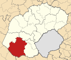
Map of the Free State with Kopanong highlighted (2011).svg
Basisdaten
Staat Südafrika
Provinz Freistaat
Distrikt Xhariep
Sitz TrompsburgVorlage:Infobox Verwaltungseinheit/Wartung/Sonstiges
Fläche 15.243 km²
Einwohner 49.423 (24. Oktober 2007)
Dichte 3,2 Einwohner pro km²
Schlüssel FS162
ISO 3166-2 ZA-FS
Webauftritt www.kopanong.gov.za (englisch)
Politik
Bürgermeister Xolile MathwaVorlage:Infobox Verwaltungseinheit/Wartung/Sonstiges

Kopanong ist eine Gemeinde im Distrikt Xhariep, Provinz Freistaat, Südafrika mit Sitz in Trompsburg. Xolile Mathwa ist der Bürgermeister.[1]

Ortschaften in der Gemeinde sind : Bergmanshoogte, Bethulie, Charlesville, Edenburg, Edenhoogte, Fauresmith, Frayville, Ghost Park, Ha-Rasebei, Hydro Park, Ipopeng, Itumeleng, Jagersfontein, Lephoi, Madigetla, Madikgetla, Maphodi, Noordmansville, Phillipolis, Poding-Tse-Rolo, Qhoweng, Reddersburg, Springfontein, Trompsburg, Verwoerd Dam, Waterkloof und Williamsville (Freistaat).

Weblinks

Einzelnachweise

  1. Contact information: Kopanong Local Municipality (englisch). Abgerufen am 5. Februar 2010.

Wikimedia Foundation.

Игры ⚽ Нужно решить контрольную?

Schlagen Sie auch in anderen Wörterbüchern nach:

  • Kopanong Hotel & Conference Centre — (Бенони,Южно Африканская Республика) Категория отеля: 4 звездочный отель А …   Каталог отелей

  • Bethulie — Bethulie …   Deutsch Wikipedia

  • Liste der Gemeinden Südafrikas — Dies ist eine Liste der südafrikanischen Gemeinden. Inhaltsverzeichnis 1 Metropolgemeinden 2 Freistaat 2.1 Xhariep – Xhariep District Municipality (DC16) 2.2 …   Deutsch Wikipedia

  • Fauresmith — Fauresmith …   Deutsch Wikipedia

  • Liste der Gemeinden in der Provinz Freistaat — Die Provinz Freistaat mit eingezeichneten Distrikten und Gemeinden Die Liste der Gemeinden in der Provinz Freistaat führt alle Gemeinden (Local Municipalities) in der südafrikanischen Provinz Freistaat auf. Die Provinz Freistaat ist in 5… …   Deutsch Wikipedia

  • Bloemfontein —   City   Bloemfontein at night Nickname(s): The city of roses …   Wikipedia

  • Dobsonville, Gauteng — Dobsonville is a township in greater Soweto, Johannesburg, South Africa. It lies to the west of Meadowlands, a part of Diepmeadow, and is adjacent to Mofolo North and Zondi, which are suburbs of Soweto on its southern border. It was formerly… …   Wikipedia

  • List of South African Municipalities — This is a list of South African Municipalities. Refer to the main page for an explanation of how these are classified, and their inter relationships.Metropolitan Municipalities*City of Cape Town Metropolitan Municipality (Cape Town) (CPT)… …   Wikipedia

  • Motheo District Municipality —   District municipality   A map of the …   Wikipedia

  • Fezile Dabi District Municipality — Fezile Dabi   District municipality   Location of Fezile Dabi District Municipality …   Wikipedia

Share the article and excerpts

Direct link
Do a right-click on the link above
and select “Copy Link”