- Korois
-
 Lage von Koroinen in Turku
Koroinen ['kɔrɔi̯nɛn] (schwed. Korois) ist ein Stadtteil der finnischen Stadt Turku. Er liegt nördlich des Stadtzentrums auf einer Landzunge am Zusammenfluss der Flüsse Aurajoki und Vähäjoki. Das Gebiet von Koroinen ist größtenteils unbebaut, daher hat der Stadtteil nur 26 Einwohner (2004).
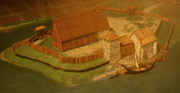
Im Mittelalter war Koroinen das Zentrum der Kirchenverwaltung Finnlands: 1229 wurde der Sitz des Bischofs von Finnland von Nousiainen nach Koroinen verlegt, da sich am Unterlauf des Aurajoki ein bedeutender Handelsplatz befand. In den 1230er Jahren wurden in die hölzerne Bischofskirche von Koroinen und eine Residenz für den Bischof gebaut. Mitte des 13. Jahrhunderts wurde die durch einen Brand zerstörte erste Bischofskirche durch eine neue, größere Holzkirche ersetzt. Möglicherweise wurde zur Zeit des Bischofs Catillus (1266–1286) ein steinerner Chor angebaut. In der Umgebung der Kirche befanden sich zwei weitere Steinbauten. Es könnte sich dabei um einen Wehrturm und den Palast des Bischofs gehandelt haben, die genaue Funktion der Gebäude ist aber genauso wenig nachgewiesen wie ihr Alter.
Als der Pegel des Aurajoki durch die Landhebung sank und der Fluss nicht mehr bis auf die Höhe von Koroinen schiffbar war, verlagerte sich der Handelsplatz an die Stelle des heutigen Stadtzentrums von Turku knapp zwei Kilometer flussabwärts. Nach Fertigstellung des Doms von Turku wurde auch der Bischofssitz Ende des 13. Jahrhunderts nach Turku verlagert. Die Kirche von Koroinen bliebt zunächst bestehen, wurde aber später (eventuell im 15. Jahrhundert) aufgegeben und verfiel völlig. 1898–1902 wurden in Koroinen die ersten systematischen archäologischen Ausgrabungen vorgenommen, bei denen die Fundamente der mittelalterlichen Steinbauten freigelegt wurden.
.jpg)
Koroinen
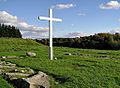
Kreuz an der Stelle der ehemaligen Kirche von Koroinen
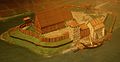
Rekonstruktion der Bischofskirche und -residenz von Koroinen

.jpg)

Wikimedia Foundation.