Lachlan Shire

Lachlan Shire
Shire of Lachlan
Australia-Map-NSW-LGA-Lachlan.png
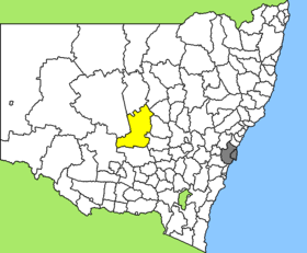
Lage des Lachlan Shire in New South Wales
Gliederung
Staat: Australien Australien
Bundesstaat: Flag of New South Wales.svg New South Wales
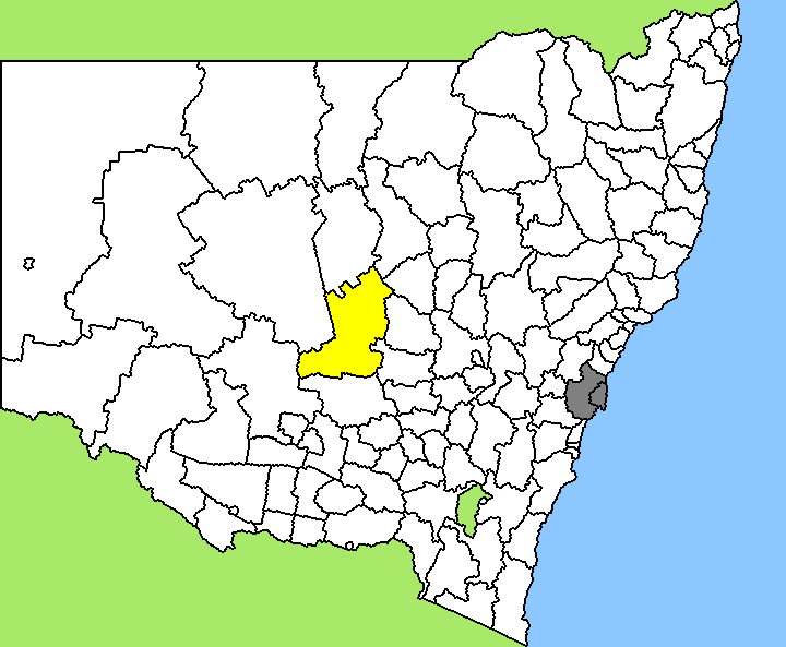
Verwaltungssitz: Condobolin
Daten und Zahlen
Fläche: 14.973 km²
Einwohner: 6.669 (2006) [1]
Bevölkerungsdichte: 0,4 Einwohner je km²
Wards: 5
-33.05147.15

Lachlan Shire ist ein lokales Verwaltungsgebiet (LGA) im australischen Bundesstaat New South Wales. Das Gebiet ist 14.973 km² groß und hat etwa 6.700 Einwohner.

Lachlan liegt im Zentrum des Staates in der Region Central West etwa 460 km westlich der Metropole Sydney und 300 km nordwestlich der australischen Hauptstadt Canberra. Das Gebiet umfasst 77 Ortsteile und Ortschaften, darunter Albert, Burcher, Burgooney, Condobolin, Fairholme, Fifield, Lake Cargelligo, Tottenham, Tullibigeal und Teile von Derriwong und Tullamore. Der Sitz des Shire Councils befindet sich in Condobolin im Zentrum der LGA, wo etwa 2.800 Einwohner leben.

Verwaltung

Der Lachlan Shire Council hat 15 Mitglieder, die von den Bewohnern der fünf Wards gewählt werden (je drei Councillor aus den Wards A bis E). Diese fünf Bezirke sind unabhängig von den Ortschaften festgelegt. Aus dem Kreis der Councillor rekrutiert sich auch der Mayor (Bürgermeister) des Councils.

Weblinks

Einzelnachweise

  1. Australian Bureau of Statistics (25. Oktober 2007): Lachlan (A) (Local Government Area) (Englisch). 2006 Census QuickStats. Abgerufen am 6. April 2010.

Wikimedia Foundation.

Игры ⚽ Поможем решить контрольную работу

Schlagen Sie auch in anderen Wörterbüchern nach:

  • Lachlan Shire Council — Infobox Australian Place | type = lga name = Lachlan Shire state = nsw caption = Location in New South Wales pop = 7,180 (2001 census)Census 2001 AUS|id=LGA14600|name=Lachlan (A) (Local Government Area)|accessdate=2007 06 30] area = 7431 est =… …   Wikipedia

  • Upper Lachlan Shire — Lage des Upper Lachlan Shire in New South Wales Gliederung …   Deutsch Wikipedia

  • Upper Lachlan Shire Council — Infobox Australian Place | type = lga name = Upper Lachlan state = nsw caption = Location in NSW pop = 7,316 area = 7102 est = seat = Crookwell (44 Spring Street)cite web title=Upper Lachlan Shire Council publisher = Department of Local… …   Wikipedia

  • Upper Lachlan Shire — Admin ASC 2 Code Orig. name Upper Lachlan Shire Country and Admin Code AU.02.17640 AU …   World countries Adminstrative division ASC I-II

  • Lachlan — or Loughlin is a boy s name of Scottish Gaelic origin. Etymology Lochlainn means Of the lake / from the land of lakes , a reference to Norway which was called Lochlann in Scotland. Thus, it used to refer to a Viking ancestor. As well as referring …   Wikipedia

  • Lachlan Macquarie — Major General Lachlan Macquarie CB 5th Governor of New South Wales …   Wikipedia

  • Lachlan River — Infobox River river name = Lachlan River caption = The Lachlan River at Cowra origin = east of Gunning mouth = confluence with the Murrumbidgee River near Oxley basin countries = Australia length = 1450 km (901 mi) elevation = discharge =… …   Wikipedia

  • Lachlan Valley Railway — Not to be confused with the former Lachlan Valley Rail Freight The Lachlan Valley Railway Society Cooperative Limited is a rail preservation society based at Cowra, New South Wales, Australia [cite news|title=Travel: Cowra|work=Sydney Morning… …   Wikipedia

  • Wakool Shire — Shire of Wakool New South Wales Location in New South Wales Population: 4,427(2009) …   Wikipedia

  • Hay Shire — Shire of Hay Lage des Hay Shire in New South Wales Gliederung …   Deutsch Wikipedia

Share the article and excerpts

Direct link
Do a right-click on the link above
and select “Copy Link”