Lairg

Lairg
Lairg
Koordinaten 58° 2′ N, 4° 24′ W58.0275-4.4025Koordinaten: 58° 2′ N, 4° 24′ W
Lairg (Schottland)
Lairg
Lairg
Verwaltung
Post town LAIRG
Postleitzahlen­abschnitt IV27
Vorwahl 01549
Landesteil Scotland
Unitary authority Highland
Britisches Parlament Caithness, Sutherland and Easter Ross
Schottisches Parlament Caithness, Sutherland and Ross
Lairg

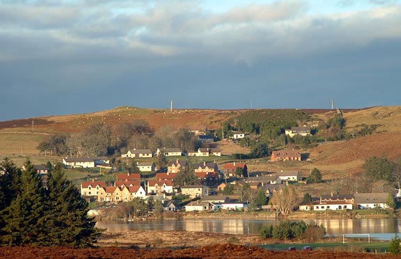
Lairg (gäl. An Luirg ) ist eine Stadt in Sutherland in den nördlichen Highlands in Schottland. Sie hat etwa 900 Einwohner.

Sie liegt am süd-östlichen Ende von Loch Shin und ist damit eine der wenigen Städte dieser Größe in den nördlichen Highlands, die nicht an der Küste liegen. Ihre relative Größe verdankt Lairg der Eisenbahnanbindung während des 19. Jahrhunderts. Lairg ist ansonsten nur durch zwei single track roads (einspurige Straßen) angebunden.

Die Stadt ist außerdem ein wichtiger Markt für Schafe. Es finden dort einige der größten Auktionen Europas statt. Ein Archäologischer Pfad auf dem Ord Hill ist bei Lairg ausgeschildert.

Weblinks


Wikimedia Foundation.

Игры ⚽ Поможем сделать НИР

Schlagen Sie auch in anderen Wörterbüchern nach:

  • Lairg —    LAIRG, a parish, in the county of Sutherland, 19 miles (W. by N.) from Golspie; containing 913 inhabitants, of whom 69 are in the village. The name of Lairg is generally supposed to be derived from the Gaelic word Lorg, signifying a footpath,… …   A Topographical dictionary of Scotland

  • lairg — lairg(e obs. Sc. form of large …   Useful english dictionary

  • Lairg — Coordinates: 58°01′N 4°24′W / 58.02°N 4.40°W / 58.02; 4.40 …   Wikipedia

  • Lairg railway station — Infobox UK station name = Lairg other name= Luirg code = LRG caption = manager = First ScotRail locale = Lairg borough = Highland start = platforms = 2 lowusage0405 = 4,096 lowusage0506 = 4,126 lowusage0607 = 3,724 years = 28 July 1874 events =… …   Wikipedia

  • Derry Irvine, Baron Irvine of Lairg — The Right Honourable The Lord Irvine of Lairg PC QC Lord Chancellor In office 2 May 1997 – 16 June 2003 Prime Minister …   Wikipedia

  • Achiemore, Lairg, Sutherland — infobox UK place country = Scotland official name= Achiemore scots name= gaelic name= population= os grid reference=NC412656 map type=Scotland latitude=58.54999 longitude= 4.72913 unitary scotland= Highland lieutenancy scotland= constituency… …   Wikipedia

  • lairge — lairg(e obs. Sc. form of large …   Useful english dictionary

  • A836 road — The A836 road is entirely within the Highland area of Scotland, and 129 miles (208 km) long.It branches from the A9 near Tain and runs generally north through Bonar Bridge and Lairg, until Tongue. Between Lairg and Tongue the road is single track …   Wikipedia

  • Far North Line — Overview System National Rail Status Operational …   Wikipedia

  • Archäologischer Pfad auf dem Ord Hill — Ein Archäologischer Pfad auf dem Ord Hill (engl. Ord Hill Archaeology Trail) liegt bei Lairg in der schottischen Grafschaft Sutherland in den Highlands. Neben einem Henge (abseits des ausgezeichneten Pfades) und einem Burnt Mound finden sich… …   Deutsch Wikipedia

Share the article and excerpts

Direct link
Do a right-click on the link above
and select “Copy Link”