Lake Wilkie

Lake Wilkie
Lake Wilkie
Lake Wilkie reflections.JPG
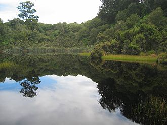
Geographische Lage The Catlins, Otago, Südinsel, Neuseeland
Daten
Koordinaten 46° 34′ 49″ S, 169° 26′ 20″ O-46.580308333333169.43881388889Koordinaten: 46° 34′ 49″ S, 169° 26′ 20″ O
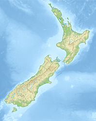
Lake Wilkie (Neuseeland)
Lake Wilkie
Fläche 1,7 Hektardep1f5
Besonderheiten

Moorsee

Lake Wilkie ist ein kleiner See nahe der Tautuku Bay in der Landschaft The Catlins südlich von Dunedin auf der Südinsel Neuseelands. Er bildete sich nach der letzten Eiszeit hinter Sanddünen und schrumpfte allmählich auf seine heutige Größe von 1,7 Hektar. Moorseen wie der Lake Wilkie sind in diesem Teil Neuseelands ungewöhnlich, eine weitere Besonderheit ist die Population einer eingeführten Art winziger Frösche.

Der See ist nicht weit von der Straße entfernt. Mehrere Schilder erläutern das Fortschreiten der Verlandung und die dabei aufeinander folgenden Pflanzen. Der Übergang von Sphagnum-Moos bis zum ausgewachsenen Wald erfolgt hier innerhalb nur 65 Metern.


Wikimedia Foundation.

Игры ⚽ Нужно решить контрольную?

Schlagen Sie auch in anderen Wörterbüchern nach:

  • Lake Wilkie — Infobox lake lake name = Lake Wilkie image lake = Lake Wilkie reflections.jpg caption lake = image bathymetry = caption bathymetry = location = the Catlins, South Island coords = coord|46.580309|S|169.438813|E|region:NZ… …   Wikipedia

  • Lago Wilkie — País  Nueva Zelanda Región …   Wikipedia Español

  • Duck Lake, Saskatchewan — Town of Duck Lake   Town   Duck Lake Town Office …   Wikipedia

  • Catlins — The Catlins (manchmal auch The Catlins Coast) ist ein Gebiet im Südwesten der Südinsel Neuseelands zwischen Balclutha und Invercargill. Es streift die Grenze zwischen den Regionen Otago und Southland und umfasst auch den südlichsten Punkt der… …   Deutsch Wikipedia

  • Southern Scenic Route — Die Southern Scenic Route ist eine touristische Straße im Süden der Südinsel Neuseelands. Sie verbindet das Fiordland, Te Anau und die Milford Road über Riverton, Invercargill und The Catlins[1] mit Dunedin . Inhaltsverzeichnis 1 Geschichte und… …   Deutsch Wikipedia

  • The Catlins — (sometimes referred to as The Catlins Coast) comprises an area in the southeastern corner of the South Island of New Zealand. The area lies between Balclutha and Invercargill, straddling the boundary between the Otago and Southland regions. It… …   Wikipedia

  • The Catlins — (manchmal auch The Catlins Coast) ist ein Gebiet im Südwesten der Südinsel Neuseelands zwischen Balclutha und Invercargill. Es streift die Grenze zwischen den Regionen Otago und Southland und umfasst auch den südlichsten Punkt der Südinsel, Slope …   Deutsch Wikipedia

  • Minnesota Valley National Wildlife Refuge — IUCN Category IV (Habitat/Species Management Area) …   Wikipedia

  • List of communities in Saskatchewan — Communities of the Province of Saskatchewan, Canada are incorporated towns, cities, villages, and resort villages and unincorporated organized hamlets.[1] Regional rural forms of administration are rural municipalities.[clarification needed]… …   Wikipedia

  • List of newspapers in Canada — This list of newspapers in Canada is a list of newspapers printed and distributed in Canada. Contents 1 National English language newspapers 2 Local daily (with a circulation of over 10,000) 2.1 Alberta …   Wikipedia

Share the article and excerpts

Direct link
Do a right-click on the link above
and select “Copy Link”