Lopy Island

Lopy Island

Vorlage:Infobox Insel/Wartung/Fläche fehlt

Lopy Island
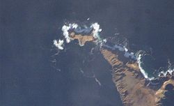
NASA-Bild von Lopy, an der Nordspitze von Khvostof
Gewässer Pazifischer Ozean
Inselgruppe Rat Islands
Geographische Lage 51° 58′ 38″ N, 178° 20′ 40″ O51.977222222222178.34444444444107Koordinaten: 51° 58′ 38″ N, 178° 20′ 40″ O
Lopy Island (Alaska)
Lopy Island
Höchste Erhebung 107 m
Einwohner (unbewohnt)

Lopy Island ist eine kleine unbewohnte Insel der Rat Islands und gehört zu den Aleuten. Die Insel liegt am nördlichen Ende von Khvostof Island und erreicht eine Höhe von 107 m.

Lopy ist wahrscheinlich wie die Nachbarinseln Davidof und Pyramid der Überrest eines Calderarandes. Die Caldera war Teil eines Vulkanes, der im Tertiär in Folge eines explosiven Ausbruchs zum größten Teil zerstört wurde.

Weblinks


Wikimedia Foundation.

Игры ⚽ Нужна курсовая?

Schlagen Sie auch in anderen Wörterbüchern nach:

  • Amchitka Island — Die Standorte der drei Kernwaffentests Bild aus Film über den Test Long Shot Amchitka ist eine vulkanische, tektonisch instabile Ins …   Deutsch Wikipedia

  • Davidof Island — NASA Picture of Davidof, on left side Khvostof Island …   Wikipedia

  • Pyramid Island (Alaska) — Vorlage:Infobox Insel/Wartung/Fläche fehlt Pyramid Island NASA Bild von Khvostof und …   Deutsch Wikipedia

  • Davidof Island — Vorlage:Infobox Insel/Wartung/Fläche fehlt Davidof Island NASA Bild von Davidof, links Khvostof …   Deutsch Wikipedia

  • Rat Island (Alaska) — Rat Island NASA Bild von Rat Island Gewässer Pazifik Inselgruppe …   Deutsch Wikipedia

  • Segula Island — Vorlage:Infobox Insel/Wartung/Fläche fehlt Segula Island Satellitenbild von Segula Island Gewässer Pazif …   Deutsch Wikipedia

  • Tanadak Island (Rat Islands) — Vorlage:Infobox Insel/Wartung/Bild fehltVorlage:Infobox Insel/Wartung/Fläche fehltVorlage:Infobox Insel/Wartung/Höhe fehlt Tanadak Island Gewässer Pazifischer Ozean Inselgruppe Aleuten …   Deutsch Wikipedia

  • Little Sitkin Island — Little Sitkin Little Sitkin aus dem All gesehen Höhe 1.188  …   Deutsch Wikipedia

  • Semisopochnoi Island — Südlicher Teil von Semisopochnoi Gewässer Pazifischer Ozean …   Deutsch Wikipedia

  • Khvostof Island — Vorlage:Infobox Insel/Wartung/Fläche fehlt Khvostof NASA Bild von Khvostof, rechts Pyramid Island …   Deutsch Wikipedia

Share the article and excerpts

Direct link
Do a right-click on the link above
and select “Copy Link”