Lukachukai

Lukachukai
Lukachukai
Apache County Incorporated and Unincorporated areas Lukachukai highlighted.svg
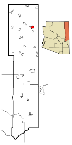
Lage im County und in Arizona
Basisdaten
Staat: Vereinigte Staaten
Bundesstaat: Arizona
County:

Apache County

Koordinaten: 36° 25′ N, 109° 14′ W36.418611111111-109.236388888891996Koordinaten: 36° 25′ N, 109° 14′ W
Zeitzone: Mountain Standard Time (UTC−7)
Einwohner: 1565 (Stand: 2000)
Bevölkerungsdichte: 27,5 Einwohner je km²
Fläche: 57,0 km² (ca. 22 mi²)
Höhe: 1996 m
Postleitzahl: 86507
Vorwahl: +1 928
FIPS: 04-42660
GNIS-ID: 0007539

Lukachukai (Navajo: Lókʼaaʼchʼégai) ist ein Census-designated place im Apache County im US-Bundesstaat Arizona. Er hat 1565 Einwohner auf einer Fläche von 56 km². Die Bevölkerungsdichte liegt bei 27,4/km².


Wikimedia Foundation.

Игры ⚽ Нужна курсовая?

Schlagen Sie auch in anderen Wörterbüchern nach:

  • Lukachukai — Lukachukai, AZ U.S. Census Designated Place in Arizona Population (2000): 1565 Housing Units (2000): 634 Land area (2000): 22.030020 sq. miles (57.057488 sq. km) Water area (2000): 0.000000 sq. miles (0.000000 sq. km) Total area (2000): 22.030020 …   StarDict's U.S. Gazetteer Places

  • Lukachukai, AZ — U.S. Census Designated Place in Arizona Population (2000): 1565 Housing Units (2000): 634 Land area (2000): 22.030020 sq. miles (57.057488 sq. km) Water area (2000): 0.000000 sq. miles (0.000000 sq. km) Total area (2000): 22.030020 sq. miles… …   StarDict's U.S. Gazetteer Places

  • Lukachukai — Original name in latin Lukachukai Name in other language State code US Continent/City America/Denver longitude 36.41695 latitude 109.22871 altitude 1999 Population 1701 Date 2011 05 14 …   Cities with a population over 1000 database

  • Lukachukai (Arizona) — Lukachukai Lugar designado por el censo de los Estados Unidos …   Wikipedia Español

  • Lukachukai, Arizona — Infobox Settlement official name = Lukachukai, Arizona settlement type = CDP imagesize = image caption = image imagesize = image caption = image mapsize = 250px map caption = Location in Apache County and the state of Arizona mapsize1 = map… …   Wikipedia

  • 86507 — Lukachukai, Az (Miscellaneous » ZIP Codes) …   Abbreviations dictionary

  • Chuska Mountains — The Chuska Mountains are an elongate range on the Colorado Plateau and within the Navajo Nation. The range is about 80 by 15 km (50 by 10 miles), and it trends north northwest and is crossed by the state line between Arizona and New Mexico.… …   Wikipedia

  • Chinle, Arizona —   CDP   …   Wikipedia

  • Dennehotso, Arizona —   CDP   Location in Apache County and …   Wikipedia

  • Many Farms, Arizona —   CDP   Location in Apache County and …   Wikipedia

Share the article and excerpts

Direct link
Do a right-click on the link above
and select “Copy Link”