Magalang

Magalang
Municipality of Magalang
Lage von Magalang in der Provinz Pampanga
Karte
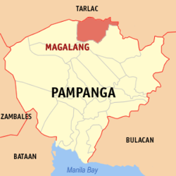
Basisdaten
Bezirk: Central Luzon
Provinz: Pampanga
Barangays: 27
Distrikt: 1. Distrikt von Pampanga
PSGC: 035411000
Einkommensklasse: 2. Einkommensklasse
Haushalte: 15.257
Zensus 1. Mai 2000
Einwohnerzahl: 98.595
Zensus 1. August 2007
Koordinaten: 15° 13′ N, 120° 40′ O15.216666666667120.66666666667Koordinaten: 15° 13′ N, 120° 40′ O
Postleitzahl: 2011
Bürgermeister: Lyndon A. Cunanan
Geographische Lage auf den Philippinen
Magalang (Philippinen)
Magalang
Magalang

Magalang ist eine philippinische Stadtgemeinde in der Provinz Pampanga. Nach dem Zensus vom 1. Mai 2000 hat sie 77.530 Einwohner in 15.257 Haushalten.

Baranggays

Magalang ist politisch in 27 Baranggays unterteilt.

  • Camias
  • Dolores
  • Escaler
  • La Paz
  • Navaling
  • San Agustin
  • San Antonio
  • San Francisco
  • San Ildefonso
  • San Isidro
  • San Jose
  • San Miguel
  • San Nicolas 1st (Pob.)
  • San Nicolas 2nd
  • San Pablo (Pob.)
  • San Pedro I
  • San Pedro II
  • San Roque
  • San Vicente
  • Santa Cruz (Pob.)
  • Santa Lucia
  • Santa Maria
  • Santo Niño
  • Santo Rosario
  • Bucanan
  • Turu
  • Ayala

Wikimedia Foundation.

Игры ⚽ Нужен реферат?

Schlagen Sie auch in anderen Wörterbüchern nach:

  • Magalang — Original name in latin Magalang Name in other language Magalan, Magalang State code PH Continent/City Asia/Manila longitude 15.2151 latitude 120.6596 altitude 46 Population 68988 Date 2011 07 31 …   Cities with a population over 1000 database

  • Magalang, Pampanga — Magalang   Municipality   Map of Pampanga showing the location of Magalang …   Wikipedia

  • Concepcion, Tarlac — Concepcion Ili iti Concepcion Bayan ng Concepcion   Municipality   …   Wikipedia

  • Kung Fu Kids — infobox television bgcolor=#c00 fgcolor=#fff show name = Kung Fu Kids caption = format = Comedy, Action, Fantasy, Adventure picture format = 480i SDTV runtime = 30 45 mins. creator = ABS CBN director = Malou Sevilla Richard Arellano executive… …   Wikipedia

  • Pampanga — Infobox Philippine province name = Pampanga sealfile = Ph seal of pampanga.png region = Central Luzon (Region III) capital = City of San Fernando founded = December 11, 1571 pop2000 = 1,882,730 pop2000rank = 10th largest popden2000 = 863… …   Wikipedia

  • Mount Arayat — as seen from the northwest, on a detour from the North Luzon Expressway Elevation …   Wikipedia

  • Mabalacat, Pampanga — Infobox Philippine municipality infoboxtitle = Mabalacat, Pampanga sealfile = locatormapfile= Ph locator pampanga mabalacat.png caption = Map of Pampanga showing the location of Mabalacat region = Central Luzon (Region III) province = Pampanga… …   Wikipedia

  • Norman Gonzales — Jersey No. 28 Position Small Forward/Power Forward Personal Info Country   …   Wikipedia

  • North Luzon Expressway — formerly North Diversion Road Marcelo H. del Pilar Superhighway Radial Road 8 Route information Maintained by Tollways Management Corporation …   Wikipedia

  • Daniel Romualdez — Daniel Z. Romualdez 10th Speaker of the House of Representatives of the Philippines In office January 27, 1958 – March 9, 1962 President Carlos P. Garcia (1958 1961) Diosdado Macapagal (1961 1962) Preceded by …   Wikipedia

Share the article and excerpts

Direct link
Do a right-click on the link above
and select “Copy Link”