- Masantol
-
Municipality of Masantol Lage von Masantol in der Provinz Pampanga 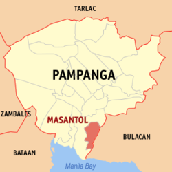
Basisdaten Bezirk: Central Luzon Provinz: Pampanga Barangays: 26 Distrikt: 4. Distrikt von Pampanga PSGC: 035412000 Einkommensklasse: 3. Einkommensklasse Haushalte: 8899 Zensus 1. Mai 2000Einwohnerzahl: 50.984 Zensus 1. August 2007Koordinaten: 14° 54′ N, 120° 43′ O14.9120.71666666667Koordinaten: 14° 54′ N, 120° 43′ O Postleitzahl: 2017 Vorwahl: +63 45 Offizielle Webpräsenz: Masantol Geographische Lage auf den Philippinen 

Masantol Masantol ist eine philippinische Stadtgemeinde in der Provinz Pampanga. Nach dem Zensus vom 1. Mai 2000 hat sie 48.120 Einwohner in 8899 Haushalten.
Baranggays
Masantol ist politisch in 26 Baranggays unterteilt.
- Alauli
- Bagang
- Balibago
- Bebe Anac
- Bebe Matua
- Bulacus
- San Agustin (Caingin)
- Santa Monica (Caingin)
- Cambasi
- Malauli
- Nigui
- Palimpe
- Puti
- Sagrada (Tibagin)
- San Isidro Anac
- San Isidro Matua (Pob.)
- San Nicolas (Pob.)
- San Pedro
- Santa Cruz
- Santa Lucia Matua
- Santa Lucia Paguiaba
- Santa Lucia Wakas
- Santa Lucia Anac (Pob.)
- Sapang Kawayan
- Sua
- Santo Niño
Weblinks
Städte und Stadtgemeinden in der Provinz PampangaStädte: Angeles City | San Fernando City
Stadtgemeinden: Apalit | Arayat | Bacolor | Candaba | Floridablanca | Guagua | Lubao | Mabalacat | Macabebe | Magalang | Masantol | Mexico | Minalin | Porac | San Luis | San Simon | Santa Ana | Santa Rita | Santo Tomas | Sasmuan
Wikimedia Foundation.
Schlagen Sie auch in anderen Wörterbüchern nach:
Masantol — Original name in latin Masantol Name in other language Masantol State code PH Continent/City Asia/Manila longitude 14.896 latitude 120.7092 altitude 5 Population 41278 Date 2011 07 31 … Cities with a population over 1000 database
Masantol, Pampanga — Masantol Municipality Map of Pampanga showing the location of Masantol … Wikipedia
Calumpit, Bulacan — Infobox Philippine municipality infoboxtitle = Bayan ng Calumpit, Bulacan sealfile = Ph seal bulacan calumpit.png locatormapfile = Ph locator bulacan calumpit.png caption = Map of Bulacan showing the location of Calumpit region = Central Luzon… … Wikipedia
Pampanga — Infobox Philippine province name = Pampanga sealfile = Ph seal of pampanga.png region = Central Luzon (Region III) capital = City of San Fernando founded = December 11, 1571 pop2000 = 1,882,730 pop2000rank = 10th largest popden2000 = 863… … Wikipedia
Apalit, Pampanga — Infobox Philippine municipality infoboxtitle = Municipality of Apalit sealfile = Ph seal pampanga apalit.png region = Central Luzon (Region III) province = Pampanga founded = pop2000 = 78,295 popden2000 = areakm2 = 72 coordinates = 14°57′N… … Wikipedia
Orani, Bataan — Orani Bayan ng Orani Municipality Nickname(s): I love ORANI Motto: Smile Orani … Wikipedia
Magalang, Pampanga — Magalang Municipality Map of Pampanga showing the location of Magalang … Wikipedia
Mexico, Pampanga — For other uses, see Mexico (disambiguation). Municipality of Mexico Balen ning México Bayan ng México Municipality … Wikipedia
Minalin, Pampanga — Minalin Municipality Nickname(s): the Egg basket of the Philippines … Wikipedia
List of cities and municipalities in the Philippines — This is a list of cities and municipalities in the Philippines arranged by province and in alphabetical order. As of 2006, there are 118 cities and 1509 municipalities.As of September 4, 2007, there are 136 cities, 1,495 municipalities, 81… … Wikipedia
Masantol


18+
© Academic, 2000-2026
- Kontaktieren Sie uns: Unterstützung, Werbung
Wörterbücher Export, schritte mit PHP, Joomla, Drupal, WordPress, MODx.