- Mbinga
-
Mbinga 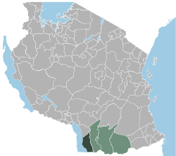
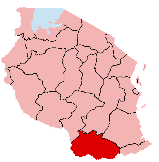
Basisdaten Staat Tansania Fläche 11.396 km² Einwohner 404.799 (2002[1]) Dichte 35,5 Einwohner pro km² ISO 3166-2 TZ-21 Mbinga ist einer von fünf Distrikten der Region Ruvuma in Tansania. Im Norden wird er durch die Region Iringa begrenzt, im Osten sowohl durch Songea Rural als auch durch Songea Urban, im Süden durch Mosambik und schließlich im Westen durch den Malawisee.
Der Distrikt hatte im Jahre 2002 404.799 Einwohner.[2] Die katholische Diözese Mbinga im Distrikt ist seit 1987 in einer Partnerschaft mit der Diözese von Würzburg. [3] Kaffee von Kleinbauern wird über den Verein "Würzburger Partnerkaffee e.V." in Deutschland mit Hilfe der GEPA vertrieben.[4]
Verwaltungsbezirke
Mbinga ist in 37 Verwaltungsbezirke unterteilt:
- Chiwanda
- Kigonsera
- Kihagara
- Kihangi Mahuka
- Kilimani
(Deutsche Bedeutung: Auf dem Berg) - Kilosa
- Kingerikiti
- Kitura
- Langiro
- Liparamba
- Lipingo
- Linda
- Litembo
- Lituhi
- Litumbandyosi
- Liuli
- Maguu
- Matiri
- Mbaha
- Mbamba Bay
- Mbangamao
- Mbinga Urban
- Mbuji
- Mikalanga
- Mkumbi
- Mpapa
- Mpepai
- Mtipwili
- Myangayanga
- Ndongosi
- Ngima
- Ngumbo
- Nyoni
- Ruanda
- Tingi
- Ukata
- Utiri
Einzelnachweise
- ↑ Eintrag auf der Webseite Tansanias
- ↑ http://www.tanzania.go.tz/census/census/districts/mbinga.htm
- ↑ http://www.bistum-wuerzburg.de/bwo/dcms/sites/bistum/information/mbinga/chronik.html
- ↑ http://www.gepa.de/p/index.php/mID/2/lan/de

 Distrikte der Region Ruvuma
Mbinga | Namtumbo | Songea Rural | Songea Urban | Tunduru
Wikimedia Foundation.
Schlagen Sie auch in anderen Wörterbüchern nach:
Mbinga — this article is about the Tanzanian town and ward. For the district see Mbinga (district) Mbinga Town and ward … Wikipedia
Mbinga — Original name in latin Mbinga Name in other language Mbinga State code TZ Continent/City Africa/Dar es Salaam longitude 10.93333 latitude 35.01667 altitude 1357 Population 25192 Date 2012 01 17 … Cities with a population over 1000 database
Mbinga (district) — Mbinga is one of the 5 districts of the Ruvuma Region of Tanzania. It is bordered to the North by the Iringa Region, to the East by the Songea Rural and Songea Urban Districts, to the South by Mozambique and to the West by Lake Nyasa. According… … Wikipedia
Mbinga District — Admin ASC 2 Code Orig. name Mbinga District Country and Admin Code TZ.14.877996 TZ … World countries Adminstrative division ASC I-II
Bistum Mbinga — Basisdaten Staat Tansania Metropolitanbistum Erzbistum Songea … Deutsch Wikipedia
Roman Catholic Diocese of Mbinga — Infobox Diocese| jurisdiction=Diocese name=Mbinga latin=Dioecesis Mbingaënsis country=Tanzania metropolitan=Songea rite=Latin Rite area= 11,400 population= 461,579 population as of= 2004 catholics= 346,712 catholics percent= 75.1 bishop=Emmanuel… … Wikipedia
Matengo people — The Matengo are an ethnic and linguistic group based in Mbinga District,[1] Ruvuma Region in southern Tanzania. In 1957, the population estimate was 57,000,[2] while in 2010, the Matengo population was estimated to number 284,000. Their religious … Wikipedia
Matengo Highlands — Location The Matengo Highlands are located in the western part of the mountainous area of Mbinga District, Ruvuma Region in southern Tanzania. They are home to the Matengo people. Kindimba is the historical center of the highlands.[ … Wikipedia
Bio-Diesel — Biodiesel Biodieselprobe Andere Namen Fettsäuremethylester (FAME), „Fettsäuren, C16–18 und C18 ungesättigt, Methylester“[1] … Deutsch Wikipedia
Fettsäure-Methylester — Biodiesel Biodieselprobe Andere Namen Fettsäuremethylester (FAME), „Fettsäuren, C16–18 und C18 ungesättigt, Methylester“[1] … Deutsch Wikipedia
Mbinga

18+
© Academic, 2000-2026
- Kontaktieren Sie uns: Unterstützung, Werbung
Wörterbücher Export, schritte mit PHP, Joomla, Drupal, WordPress, MODx.