- Medicine Lodge
-
Medicine Lodge 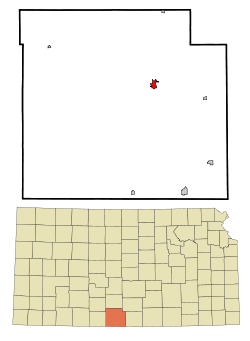 Lage in Kansas
Basisdaten Staat: Vereinigte Staaten Bundesstaat: Kansas County: Koordinaten: 37° 17′ N, 98° 35′ W37.284444444444-98.581111111111456Koordinaten: 37° 17′ N, 98° 35′ W Zeitzone: Central Standard Time (UTC−6) Einwohner: 2036 (Stand: 2006) Bevölkerungsdichte: 656,8 Einwohner je km² Fläche: 3,1 km² (ca. 1 mi²)
davon 3,1 km² (ca. 1 mi²) LandHöhe: 456 m Postleitzahl: 67104 Vorwahl: +1 620 FIPS: 20-45500 GNIS-ID: 0470446 Webpräsenz: www.cyberlodg.com/mlcity Bürgermeister: John Colborn Medicine Lodge ist die größte Stadt im Barber County im US-Bundesstaat Kansas. Sie ist County Seat (Sitz der Countyverwaltung) und liegt am Medicine Lodge River. Im Jahre 2000 hatte die Stadt 2193 Einwohner und eine Fläche von 3,1 km².
Die Stadt liegt an der Kreuzung der Highways U.S. Highway 160 und U.S. Highway 281.
Geschichte
Die Stadt befindet sich auf einem Gebiet, das bei den Kiowa als heiliges Land galt. Wegen der Streitigkeiten mit den Indianern errichtete die US-Regierung im Jahre 1874 ein Fort.
In der Nähe des heutigen Stadtgebietes wurde im Oktober 1867 der Vertrag von Medicine Lodge abgeschlossen. Die Stadt feiert in dreijährigem Abstand ein dreitägiges Fest zur Erinnerung an diesen Vertrag (letztmals im Jahre 2006).
Söhne und Töchter der Stadt
- Martina McBride, Country-Sängerin
- Dorothy DeLay, Violinpädagogin
Kategorien:- Ort in Kansas
- County Seat in Kansas

Wikimedia Foundation.