- Milton Keynes (Borough)
-
Borough of Milton Keynes 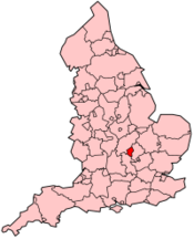
Basisdaten Status Unitary Authority, Borough Region South East England Zerem. Grafschaft Buckinghamshire Verwaltungssitz Milton Keynes Fläche 308,63 km² (154.) Einwohner (2007) 228.400 (51.) ONS-Code 00MG Website www.miltonkeynes.gov.uk Milton Keynes ist ein Borough in England. Es entstand 1974 durch einen Zusammenschluss der Urban Districts Bletchley, Newport Pagnell und Wolverton, dem Newport Pagnell Rural District und Teilen des Wing Rural District.
Bis April 1997 war das Borough of Milton Keynes ein Teil der Grafschaft Buckinghamshire. Seitdem ist es eine Unitary Authority, die verwaltungstechnisch von Buckinghamshire unabhängig ist. Das Borough grenzt an die Verwaltungsgrafschaften Buckinghamshire, Bedfordshire und Northamptonshire. Der größte Ort ist Milton Keynes.
In Milton Keynes befindet sich die Open University - größte Universität des Vereinigten Königreichs, und Bletchley Park, wo Alan Turing und andere im Zweiten Weltkrieg an der Entzifferung des Enigma-Codes arbeiteten.
Städte, Dörfer und Gemeinden
- Astwood
- Bletchley, Bow Brickhill, Bradwell, Broughton
- Caldecote, Castlethorpe, Chicheley, Clifton Reynes, Cold Brayfield
- Emberton
- Fenny Stratford, Filgrave
- Gayhurst, Great Linford
- Hanslope, Hardmead, Haversham
- Lathbury, Lavendon, Lillingstone Dayrell, Lillingstone Lovell, Little Brickhill, Little Linford, Long Street, Loughton
- Middleton, Milton Keynes, Moulsoe
- Newport Pagnell, Newton Blossomville, North Crawley
- Olney
- Ravenstone
- Shenley Brook End, Shenley Church End, Sherington, Simpson, Stantonbury, Stoke Goldington, Stony Stratford
- Tattenhoe, Tongwell, Tyringham
- Walton, Warrington, Water Eaton, Wavendon, Weston Underwood, Willen, Woburn Sands, Wolverton, Woolstone, Woughton on the Green
Kategorien:- Unitary Authority (England)
- Borough (South East England)
- Milton Keynes (Unitary Authority)

Wikimedia Foundation.