Ardvasar

Ardvasar
Ardvasar
Koordinaten 57° 4′ N, 5° 55′ W57.058888888889-5.9102777777778Koordinaten: 57° 4′ N, 5° 55′ W
Ardvasar (Schottland)
Ardvasar
Ardvasar
Verwaltung
Post town ISLE OF SKYE
Postleitzahlen­abschnitt IV45
Vorwahl 01471
Landesteil Scotland
Unitary authority Highland
Britisches Parlament Ross, Skye and Lochaber
Schottisches Parlament Skye, Lochaber and Badenoch
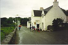
Durchgangsstraße und Hotel in Ardvasar

Ardvasar (schottisch-gälisch: Àird a’ Bhàsair) ist ein schottisches Dorf auf der Halbinsel Sleat, welche im äußersten Süden der Isle of Skye liegt.

Im Nordosten von Ardvasar befindet sich die Anlegestelle der Fähren, die die Isle of Skye mit Mallaig auf dem schottischen Festland verbinden. Noch etwas weiter nördlich liegt die Ruine von Armadale Castle, auf dessen Gelände sich das Museum of the Isles befindet.

Weblinks

 Commons: Ardvasar – Sammlung von Bildern, Videos und Audiodateien

Wikimedia Foundation.

Игры ⚽ Поможем сделать НИР

Schlagen Sie auch in anderen Wörterbüchern nach:

  • Ardvasar — infobox UK place country = Scotland static static image caption= latitude= 57.05 longitude= 05.92 official name =Ardvasar population = unitary scotland= Highland shire county= Sleat constituency westminster= Highland Coucil Area post town=… …   Wikipedia

  • Sleat — Blick von Tarskavaig zu den Cuillins nach Sonnenuntergang Sleat (schottisch gälisch: Sléibhte oder Slèite) ist eine Halbinsel im Süden der Insel Skye. Sie ist durch den Sound of Sleat vom Festland getrennt. Der ursprüngliche schottisch gälische… …   Deutsch Wikipedia

  • Raasay — Location …   Wikipedia

  • Cuillin — This article is about the Cuillin of Skye. See Rùm for the Cuillin of Rùm. Sgurr nan Gillean and the Pinnacle Ridge from Basteir gorge The Cuillin (Scottish Gaelic: An Cuilthionn or An Cuiltheann) are a range of rocky mountains located on the… …   Wikipedia

  • Dunvegan Castle — Dunvegan Castle, main entrance …   Wikipedia

  • Dunvegan — For other uses, see Dunvegan (disambiguation). Coordinates: 57°26′N 6°35′W / 57.44°N 6.58°W / 57.44; 6.58 …   Wikipedia

  • Crowlin Islands — Eilean Mòr, Crowlin Islands The Crowlin Islands (Scottish Gaelic: Na h Eileanan Cròlainneach) are a group of uninhabited islands in the Inner Hebrides of Scotland. They lie between Skye and the Applecross peninsula on the mainland. The individual …   Wikipedia

  • A851 road — UK road routebox road= A851 length mi= length km= direction= North South start= Armadale destinations= end= Scullamus construction date= completion date= junctions= ukroadsmall|87The A851 road is one of the principal roads of the Isle of Skye in… …   Wikipedia

  • Duntulm — Coordinates: 57°41′N 6°20′W / 57.68°N 6.34°W / 57.68; 6.34 …   Wikipedia

  • Isleornsay — Coordinates: 57°08′44″N 5°48′32″W / 57.14569°N 5.80902°W / 57.14569; 5.80902 …   Wikipedia

Share the article and excerpts

Direct link
Do a right-click on the link above
and select “Copy Link”