Molas Pass

Molas Pass

x

Molas Pass
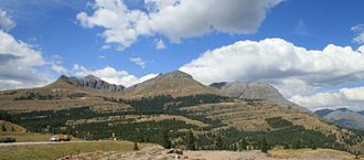
Blick vom Pass nach Nordwest. Rechts der Storm Peak in der Silverton Gruppe.

Blick vom Pass nach Nordwest. Rechts der Storm Peak in der Silverton Gruppe.

Süd Nord
Passhöhe 3.325 m
County San Juan County, Colorado (USA)
Talorte Coal Bank Pass Silverton
Ausbau US 550.svg U.S. Highway 550
Gebirge San Juan Mountains (Rocky Mountains)
Karte
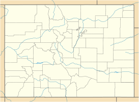
Molas Pass (Colorado)
Molas Pass
x x
Koordinaten 37° 44′ 16″ N, 107° 41′ 53″ W37.737777777778-107.698055555563325Koordinaten: 37° 44′ 16″ N, 107° 41′ 53″ W

Der Molas Pass ist ein Gebirgspass im südwestlichen Teil des US-Bundesstaates Colorado im San Juan County. Der Pass liegt zwischen dem Red Mountain Pass und dem Coal Bank Pass im San Juan National Forest und verläuft zwischen dem Coal Bank Pass im Süden und Silverton im Norden. Über den Pass führt der Million Dollar Highway, Teil des U.S. Highway 550.

Weblinks

 Commons: Molas Pass – Sammlung von Bildern, Videos und Audiodateien

Wikimedia Foundation.

Игры ⚽ Нужна курсовая?

Schlagen Sie auch in anderen Wörterbüchern nach:

  • Molas Pass — sign Elevation 10,910 ft (3,325 m) …   Wikipedia

  • Molas — may refer to: Molas, France, a commune in the Haute Garonne department Molas Pass, a high mountain pass in the San Juan Mountains of western Colorado in the United States Isidre Molas i Batllori (born 1940), the 5th President of the Socialists… …   Wikipedia

  • Coal Bank Pass — x Coal Bank Pass …   Deutsch Wikipedia

  • Coal Bank Pass — Sign at Coal Bank Pass Elevation 10,640 ft (3,243 m) …   Wikipedia

  • U.S. Route 550 — Million Dollar Highway Route information …   Wikipedia

  • List of mountain passes — This is a list of mountain passes. Africa *Halfaya Pass *Moteng Pass (Lesotho) *Mahlasela pass (Lesotho)Asia* Khunjerab Pass Pakistan China (highest international border crossing at 4693 m.) * Khyber Pass Pakistan Afghanistan * Kotal e Lataband * …   Wikipedia

  • Liste der befahrbaren Pässe in Colorado — Diese Liste befahrbarer Pässe im US Bundesstaat Colorado enthält alle asphaltierten Passstraßen, die einen Namen besitzen. Name Höhe in Meter Erschließung Wasserscheide I Wasserscheide II Cameron Pass 3132 State Route 14 Michigan River Joe Wright …   Deutsch Wikipedia

  • Ouray, Colorado — City of Ouray, Colorado   City   Ouray viewed above from Box Canyon Ni …   Wikipedia

  • San Juan Skyway — The San Juan Skyway is one of the scenic byways in the Colorado Scenic and Historic Byway System. It forms a 236 mile (379 km) loop in the southwest part of the U.S. State of Colorado traversing the heart of the San Juan Mountains. U.S. Highway… …   Wikipedia

  • Durango, Colorado — City of Durango Location in La Plata County and the State of Colorado Coordinates …   Wikipedia

Share the article and excerpts

Direct link
Do a right-click on the link above
and select “Copy Link”