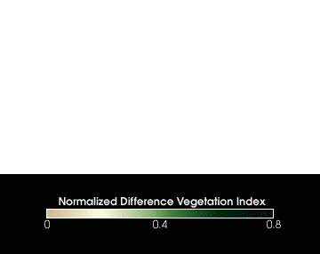
- NDVI
-
 Der globale NDVI in den 12 Monaten des Jahres 1998. Eigene Animationen lassen sich unter http://earthobservatory.nasa.gov/Observatory/Datasets/ndvi.fasir.html erstellen.
NDVI ist ein Akronym und steht für "Normalized Differenced Vegetation Index" (auch Normalized Density Vegetation Index), zu deutsch: „normalisierter differenzierter Vegetationsindex“. Er ist der wohl am häufigsten angewandte Vegetationsindex und wird auf der Basis von Satellitenbilddaten errechnet.
Hintergrund
Der Index beruht auf der Tatsache, dass gesunde Vegetation im sichtbaren Spektralbereich (Wellenlänge von etwa 400 bis 700 nm) relativ wenig und im darauf folgenden nahen Infrarot-Bereich (Wellenlänge von etwa 700 bis 1300 nm) relativ viel Strahlung reflektiert. Dabei ist die Reflexion im nahen Infrarot stark mit der Vitalität einer Pflanze korreliert - je vitaler die Pflanze, desto größer ist der Anstieg des Reflexionsgrades in diesem Spektralbereich. Andere Oberflächenmaterialien, wie Boden, Fels oder auch tote Vegetation, zeigen keinen solchen kennzeichnenden Unterschied des Reflexionsgrades beider Bereiche. Dieser Umstand kann folglich dazu dienen, zum einen mit Vegetation bedeckte von unbedeckten Flächen zu unterscheiden und zudem auf die photosynthetische Aktivität, Vitalität sowie Dichte der Vegetationsdecke zu schließen.
Der NDVI wird üblicherweise aus Daten des AVHRR-Sensors der NOAA-Satelliten berechnet, genauer aus Kanal 1 (580 bis 680 nm) und Kanal 2 (725 bis 1100 nm). Es ist aber auch möglich, andere Datengrundlagen, wie beispielsweise Landsat-Daten (Kanal 3 und 4 von TM/ ETM+ oder ASTER ) zu verwenden. Dies ist beispielsweise notwendig, wenn eine bessere geometrische Auflösung erforderlich ist. Globale Datensätze können kostenlos beim EOS Data Gateway Center (NASA) bestellt werden. Die Auflösung beträgt hier 250, 500 oder 1000 m pro Pixel, während die Intervalllänge bei 16 Tagesmittelwerten (zur Erzeugung von Wolkenfreien Bildern) bzw. Monatsmittelwerten liegt. Diese Daten werden vom MODIS-Instrument des Earth Observing Systems (EOS) gewonnen.
Berechnung
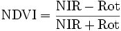
Man berechnet den NDVI aus der Reflexion im nahen Infrarot (NIR) und der Reflexion im roten sichtbaren Bereich (rot, etwa 620 bis 700 nm):
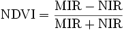
Bei starken atmosphärischen Störungen (dichte Bewölkung) wird zum Teil mit einer Näherungsformel gerechnet:
Dabei werden beide Kanäle um einen Spektralbereich verschoben: das nahe Infrarot zum mittleren Infrarot (MIR, etwa 1300 bis 3000 nm) und der rote Bereich zum nahen Infrarot.
Durch die Normierung ergibt sich ein Wertebereich zwischen -1 und +1, wobei positive Werte nahe 1 so etwas wie „viele, gesunde, photosynthetisch aktive Pflanzen pro Fläche“ bedeuten.
weitere Indices
- 'SAVI' (Soil adjusted Vegetation Indices) Familie
Wikimedia Foundation.