Oeta

Oeta

f1

Iti
Höhe 2.250 m
Lage Thessalien, Griechenland
Gebirge Pindos-Gebirge
Geographische Lage 38° 49′ 43″ N, 22° 17′ 19″ O38.82861111111122.2886111111112250Koordinaten: 38° 49′ 43″ N, 22° 17′ 19″ O
Iti (Griechenland)
DEC
Iti

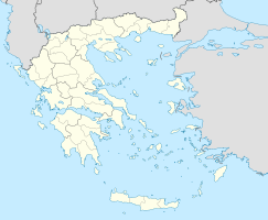
Das Iti-Gebirge (neugr. Οίτη, Iti, altgr. Οἴτη, Oítē, lat. Oita, Öta oder Oeta) ist ein südöstlicher Ausläufer des Pindos-Gebirges und nach seinem höchsten Gipfel (2.250 m) benannt. Er befindet sich in der griechischen Präfektur Fthiotida zwischen dem Tal des Sperchios und dem Oberlauf des böotischen Kifissos.

In dem östlichen Teil Καλλίδρομος (Kallidromos) reichen seine Ausläufer nahe an den Golf von Malia und lassen dort nur einen sehr schmalen Übergang frei, den berühmten Pass der „Thermopylen“. Außerdem gab es einen Hochpass im Westen des Kallidromos, der in das hochgelegene Kephisos-Tal führt.

In der Mythologie wird der „Oita“ beziehungsweise der südliche Gipfel Πυρά (Pyra, 2.183 m) als der Ort benannt, an dem der Scheiterhaufen stand, auf dem sich Herakles verbrannte, bevor er auf den Olymp gehen durfte.


Wikimedia Foundation.

Игры ⚽ Нужен реферат?

Schlagen Sie auch in anderen Wörterbüchern nach:

  • OETA — mons in finibus Thessaliae. Doridi a tergo incumbens, optimi helleboriferax, Plin. l. 4. c. 7. Pausan. l. 10. Ovid. Metam. l. 9. v. 165. Implevitque suis nemorosam vocibus Oetam. Morte et sepulchrô Herculis nobilitatus, Plin. loc. cit. Sil.… …   Hofmann J. Lexicon universale

  • Oeta — or OETA may refer to: Mount Oeta in Greece Oeta (moth), a genus of ermine moths Oklahoma Educational Television Authority, Oklahoma s network of Public Broadcasting Service (PBS) Public television television stations Occupied Enemy Territory… …   Wikipedia

  • Oeta — Oeta, Gebirge im alten Griechenland, zwischen Phocis, Lokris u. Thessalien, 4800 hoch; Engpaß der Thermopylen …   Herders Conversations-Lexikon

  • OEta — montagne de Grèce (S. de la Thessalie, 2 152 m) qui domine le défilé des Thermopyles …   Encyclopédie Universelle

  • Oeta — geographical name mountains central Greece, E spur of Pindus Mountains; highest point 7060 feet (2152 meters) …   New Collegiate Dictionary

  • Mount Oeta — (Greek: Όρος Οίτη, also transcribed as Oita, Oite or Iti; older name: Καταβόθρα) is a mountain to the south of Central Greece, in Greece, forming a boundary between the valleys of the Spercheius and the Boeotian Cephissus. It is an offshoot of… …   Wikipedia

  • Dryops (Oeta) — For other uses, see Dryops. In Greek mythology, Dryops was a son of the river god Spercheus and the Danaid Polydora. He reigned in the neighborhood of Mount Oeta[1] and was believed to have given his name to the people Dryopes; the people,… …   Wikipedia

  • Mont Oeta — Mont Œta Mont Œta Vue du sommet Géographie Altitude 2 152 m Massif Pinde …   Wikipédia en Français

  • Oklahoma Educational Television Authority — statewide Oklahoma Branding OETA Slogan The Oklahoma Network Channels Analog: see table below Digital …   Wikipedia

  • List of television stations in Oklahoma (by channel number) — Full Service Stations* Channel 2: KJRH TV, (NBC), Tulsa * Channel 3: KOET TV, (PBS/OETA), Eufaula * Channel 4: KFOR TV, (NBC), Oklahoma City * Channel 5: KOCO TV, (ABC), Oklahoma City * Channel 6: KOTV TV, (CBS), Tulsa * Channel 7: KOCO DT, (ABC) …   Wikipedia

Share the article and excerpts

Direct link
Do a right-click on the link above
and select “Copy Link”