Omorate

Omorate
4.835.966666666667
Omorate (Äthiopien)
Omorate
Omorate

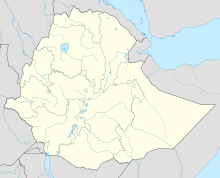
Omorate (auch Omo Rati oder Rate) ist eine Ortschaft am Fluss Omo im äußersten Südwesten Äthiopiens. Es ist Hauptort der Woreda Kuraz in der Debub-Omo-Zone der Region der südlichen Nationen, Nationalitäten und Völker und größte Ortschaft im Gebiet der Dassanetch.

Von der Grenze zu Kenia und auch vom Turkana-See ist der Ort etwa 25 km entfernt. Eine Straße verbindet Omorate mit Turmi. Zur Zeit des Derg-Regimes gab es bei Omorate ein von Nordkorea unterstütztes Projekt zum Baumwollanbau, das jedoch scheiterte.

2005 hatte Omorate nach Angaben der Zentralen Statistikagentur Äthiopiens 3.363 Einwohner.[1] Laut Volkszählung von 1994 waren von 1.857 Einwohnern 31,88 % Amharen, 20,73 % Dassanetch, 10,98 % Oromo, 9,96 % Wolaytta, 7 % Gamo, 6,25 % Gofa, 3,98 % Konso und 9,32 % Angehörige anderer ethnischer Gruppen. 42,97 % sprachen Amharisch als Muttersprache, 19,22 % Dassanetch, 8,56 % Wolaytta, 7,22 % Oromo, 5,87 % Gamo, 4,95 % Gofa, 3,23 % Konso und 7,97 % andere Sprachen.[2]

Quellen

  1. Central Statistical Agency: 2005 National Statistics, Section–B Population, Table B.4 (PDF)
  2. CSA: The 1994 Population and Housing Census of Ethiopia: Results for Southern Nations, Nationalities and Peoples’ Region, Volume I: Part I. Statistical Report on Population Size and Charateristics, (S. 160, 201)

Wikimedia Foundation.

Игры ⚽ Нужно решить контрольную?

Schlagen Sie auch in anderen Wörterbüchern nach:

  • Omorate — Abandoned powerlines near Omorate part of the abandoned North Korean cotton plantation scheme Omorate (also known as Kelem) is a town in southern Ethiopia near the Kenyan border.[1] Located in the Debub Omo Zone of the Southern Nations,… …   Wikipedia

  • Omorate — 4°48′N 35°58′E / 4.8, 35.967 …   Wikipédia en Français

  • Omo — Pour les articles homonymes, voir OMO. 4°48′1.27″N 35°58′1.45″E / …   Wikipédia en Français

  • Mago National Park — IUCN Category II (National Park) Mago National Park, February 2006 …   Wikipedia

  • Kuraz — is a woreda in the extreme south of Ethiopia. Part of the Debub Omo Zone of the Southern Nations, Nationalities and Peoples Region, Kuraz is bordered on the south by Kenya, on the west by the Ilemi Triangle (claimed by Ethiopia, Kenya and Sudan) …   Wikipedia

  • Omo (Fluss) — Omo Mündungsdelta des OmoVorlage:Infobox Fluss/KARTE fehlt DatenVorlage:Infobox Fluss/GKZ fehlt …   Deutsch Wikipedia

  • Turmi — 4.966666666666736.483333333333 Koordinaten: 4° 58′ N, 36° 29′ O …   Deutsch Wikipedia

  • Basse vallée de l'Omo — Omo Pour les articles homonymes, voir OMO. Omo L Omo au nord d Omorate …   Wikipédia en Français

  • Dassanetchs — Jeune femme Dassanetch à Omorate Populations Autre Langue(s) Daasanach Religion(s) Religions tradi …   Wikipédia en Français

  • Fleuve Omo — Omo Pour les articles homonymes, voir OMO. Omo L Omo au nord d Omorate …   Wikipédia en Français

Share the article and excerpts

Direct link
Do a right-click on the link above
and select “Copy Link”