- Sedibeng
-
Sedibeng
Sedibeng District Municipality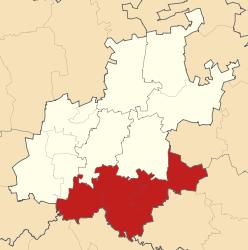
Symbole Wappen
Basisdaten Staat Südafrika Provinz Gauteng Sitz Vereeniging Fläche 4.200,3 km² Einwohner 800.826 (24. Oktober 2007) Dichte 190,7 Einwohner pro km² Schlüssel DC42 ISO 3166-2 ZA-GP Webauftritt www.sedibeng.gov.za (englisch) Politik Bürgermeister Simon Mofokeng -26.6527.966666666667Koordinaten: 26° 39′ S, 27° 58′ OSedibeng ist der südlichste Distrikt innerhalb der Provinz Gauteng in Südafrika. Er hat 800.826 Einwohner (Stand: 24. Oktober 2007)[1] auf einer Gesamtfläche von 4.200 km². Sitz der Distriktverwaltung ist Vereeniging. [2]
Der Distrikt ist ein Zentrum der Montanindustrie, vor allem der Eisenverhüttung und des Steinkohlebergbaus. Hier befindet sich einer der größten Staudämme Südafrikas, der Vaal-Stausee, der für die Energiegewinnung genutzt wird.
Sedibeng ist der Sesotho-Begriff für „am Brunnen“ oder „an der Quelle“. Der Distrikt liegt am Vaal, welcher hier die Grenze zwischen den Provinzen Gauteng und Freistaat bildet. [3]
Inhaltsverzeichnis
Gemeindestruktur
Als Beispiel für die Infrastruktur hier die Wasserversorgung der Haushalte (HWA = eigener Hauswasseranschluss; ÖWA = öffentlicher Wasseranschluss in der Nähe; KWA = kein Anschluss an ein Wasserleitungsnetz) [4]:
Gemeinde Verwaltungssitz Fläche Einwohner H W A Ö W A K W A Emfuleni Vanderbijlpark 966 km² 658.9281 25% 72% 3% Lesedi Heidelberg 1.786 km² 74.201 11% 77% 12% Midvaal Meyerton 1.725 km² 65.151 20% 60% 19% Sehenswürdigkeiten
Weblinks
- Offizieller Internetauftritt (englisch)
- Vaal Triangle Info (englisch)
Einzelnachweise
- ↑ Community Survey 2007. Basic Results. Statistics South Africa, 24. Oktober 2007, abgerufen am 29. Juni 2010 (englisch)..
Hinweise zu den Daten (englisch). - ↑ Verwaltungsgrenzen Südafrika
- ↑ Namensbedeutung Gemeinden
- ↑ Gemeindestatistik Südafrika
Distrikte von GautengCity of Johannesburg | City of Tshwane | Ekurhuleni | Metsweding | Sedibeng | West Rand
Wikimedia Foundation.
Schlagen Sie auch in anderen Wörterbüchern nach:
Sedibeng District — Sedibeng Sedibeng District Municipality Sedibeng (blau) in Gauteng (dunkelgrau) Staat: Südafrika … Deutsch Wikipedia
Sedibeng District Municipality — Sedibeng is one of the districts of Gauteng province of South Africa. The seat of Sedibeng is Vereeniging. The largest mother tongue among the 794 605 people is Sotho (2001 Census). The district code is DC42.EtymologyThe name means The place of… … Wikipedia
Sedibeng District Municipality — Admin ASC 2 Code Orig. name Sedibeng District Municipality Country and Admin Code ZA.06.DC42 ZA … World countries Adminstrative division ASC I-II
South African municipal election, 2006, in Sedibeng District Municipality — The African National Congress won:* Emfuleni * LesediThe Democratic Alliance won:* Midvaal … Wikipedia
Midvaal Local Municipality — Local municipality Location in Gauteng … Wikipedia
Gauteng — 26° S 28° E / 26, 28 … Wikipédia en Français
Liste der Gemeinden Südafrikas — Dies ist eine Liste der südafrikanischen Gemeinden. Inhaltsverzeichnis 1 Metropolgemeinden 2 Freistaat 2.1 Xhariep – Xhariep District Municipality (DC16) 2.2 … Deutsch Wikipedia
Sebokeng, Gauteng — Sebokeng is a township in southern Gauteng, South Africa near the industrial city of Vanderbijlpark (located in the district municipality of Sedibeng and the local municipality of Emfuleni). It was established by the then apartheid government in… … Wikipedia
Vanderbijlpark — (pronounced fʌndɪɹbeɪlpɑːɹk) is an industrial city next to the Vaal River in southern Gauteng, South Africa. It is home to Vanderbijlpark Steel (previously part of ISCOR (Iron and Steel Corporation), now part of the global company Mittal). With… … Wikipedia
Meyerton, Gauteng — Town … Wikipedia
Sedibeng

18+
© Academic, 2000-2026
- Kontaktieren Sie uns: Unterstützung, Werbung
Wörterbücher Export, schritte mit PHP, Joomla, Drupal, WordPress, MODx.