- West Rand
-
West Rand
West Rand District Municipality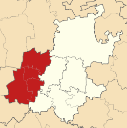
Symbole Wappen
Basisdaten Staat Südafrika Provinz Gauteng Sitz Randfontein Fläche 406.611 km² Einwohner 539.039 (24. Oktober 2007) Dichte 1,3 Einwohner pro km² Schlüssel DC48 ISO 3166-2 ZA-GP Webauftritt www.wrdm.gov.za (englisch) Politik Bürgermeister Mpho Nawa Partei African National Congress West Rand (engl. West Rand District Municipality) ist ein Distrikt in der südafrikanischen Provinz Gauteng. Der Verwaltungssitz befindet sich in Randfontein. Faith Matshikiza ist die Bürgermeisterin.[1] Der ANC stellt die Mehrheit im Rat des Distrikts.[2]
Der Name des Distrikts kommt von seiner Lage im Westen des Witwatersrand.[3] 2007 hatte der Distrikt nach Hochrechnungen 539.038 Einwohner.[4] Sie deckt ein Gebiet von 4066 Quadratkilometern ab.[5]
Inhaltsverzeichnis
Gemeinden
Gemeinde Sitz Einwohner
Schätzung 2007Fläche
(km²)Mogale City Krugersdorp 319.641 1.099,28 Randfontein Randfontein 117.261 477,10 Westonaria Westonaria 99.218 637,61 Merafong City Carletonville 215.865 1.630,57 Sterkfontein DMA Randfontein 2.918 221,55 Geografie
Die wichtigsten Orte im Distrikt sind Battery, Bekkersdal, Carletonville, Elberta, Finsbury, Glenharvie, Hekpoort, Hermina, Hillshaven, Jagfontein, Kockoord, Krugersdorp, Libanon, Luipaardsvlei, Magaliesburg, Mohlakeng, Muldersdrif, Nooitgedacht, Randfontein, Thorndale, Venterspos und Westonaria.[6]
Wirtschaft
Der größte Teil der wirtschaftlichen Aktivitäten gehört zum Dienstleistungssektor (63 Prozent des BIP des Distrikts). Der Bergbau, einst wirtschaftliches Standbein der Region, nimmt immer weiter an Wichtigkeit ab.[7]
Sehenswürdigkeiten
Weblinks
- Offizieller Internetauftritt (englisch)
Quellen
- Integrated Development Plan 2007/08 to 2011/12 (englisch) (PDF; 2,65 MB). West Rand District Municipality. Abgerufen am 27. Mai 2010.
Einzelnachweise
- ↑ Contact information: West Rand District Municipality (englisch). Government Communication and Information System. Abgerufen am 27. Mai 2010.
- ↑ Municipalities of the Republic of South Africa – Contact Details and Council Information (englisch) (PDF; 477 KB) S. 3. Department of Provincial and Local Government – Republic of South Africa (2007). Abgerufen am 1. Mai 2010.
- ↑ South African Language – Place Names (englisch). Abgerufen am 27. Mai 2010.
- ↑ Community Survey – Basic Results: Municipalities (englisch) (PDF; 0,81 MB) S. 10. Statistics South Africa (2007). Abgerufen am 1. Mai 2010.
- ↑ West Rand (englisch). Municipal Demarcation Board. Abgerufen am 27. Mai 2010.
- ↑ West Rand District Municipality Information (englisch). Department: Water and Environmental Affairs. Republic of South Africa. Abgerufen am 27. Mai 2010.
- ↑ West Rand District Municipality (Hrsg.), S. 47.
Distrikte von GautengCity of Johannesburg | City of Tshwane | Ekurhuleni | Metsweding | Sedibeng | West Rand
Wikimedia Foundation.
Schlagen Sie auch in anderen Wörterbüchern nach:
West Rand District Municipality — West Rand is the name of the urban western part of the Witwatersrand that is functionally merged with the Johannesburg conurbation. This area became settled by Europeans after a gold bearing reef discovered in 1886 and sparked the gold rush that… … Wikipedia
West Rand District Municipality — Admin ASC 2 Code Orig. name West Rand District Municipality Country and Admin Code ZA.06.DC48 ZA … World countries Adminstrative division ASC I-II
Rand — may refer to a number of places, people, organizations, and acronyms:Places* Rand, New South Wales, a small town in Australia * Rand, Lincolnshire, a small village in Lincolnshire, England * Rand, Colorado, a small unincorporated community in… … Wikipedia
Rand, West Virginia — Rand is an unincorporated community on the Kanawha River in Kanawha County, West Virginia, USA. It is surrounded by the communities of Malden and DuPont City. In recent years, Rand has has experienced a rise in crime including drugs and… … Wikipedia
Rand, Lincolnshire — Rand is a small village in the West Lindsey district of Lincolnshire, England, appx convert|9|mi|km|0 north east of the city of Lincoln and appx convert|2|mi|km|0 west of Wragby, just off the A158 road from Lincoln to Skegness in the East… … Wikipedia
Rand — Sm std. (9. Jh.), mhd. rant, ahd. rant, as. rand Stammwort. Aus g. * randa /ō Rand , auch in ae. rand, afr. rand, rond; anord. ro̧nd f. Vermutlich eine Dentalableitung zu einer Grundlage mit m, die in ae. rima Rand, Grenze, Küste und Rahmen… … Etymologisches Wörterbuch der deutschen sprache
West Grove, Iowa — West Grove is an unincorporated community in western Davis County, Iowa, United States. It lies along Iowa Highway 2 west of the city of Bloomfield, the county seat of Davis County. [Rand McNally. The Road Atlas 08. Chicago: Rand McNally, 2008, p … Wikipedia
Rand Araskog — Rand Vincent Araskog (born October 31, 1931) is a prominent U.S. businessman and an ex CEO of ITT Corporation. Araskog is of Scandinavian origin; his grandfather arrived to Minnesota from Sweden.Rand Araskog was elected as a valedictorian in his… … Wikipedia
West Kilbride — Koordinaten 55° 42′ N, 4° 51′ W … Deutsch Wikipedia
Rand Light Infantry — The Rand Light Infantry (RLI) is an infantry regiment of the South African Army. As a reserve unit, it has a status roughly equivalent to that of a British Territorial Army or United States Army National Guard unit.HistoryThe history of this… … Wikipedia
West Rand

18+
© Academic, 2000-2026
- Kontaktieren Sie uns: Unterstützung, Werbung
Wörterbücher Export, schritte mit PHP, Joomla, Drupal, WordPress, MODx.