Seven Mile Bridge

Seven Mile Bridge
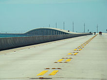
Die Seven Mile Bridge, aufgenommen während der Fahrt Richtung Key West

Die Seven Mile Bridge ist die längste Brücke des Overseas Highways, der die Inseln der Florida Keys miteinander verbindet. Sie ist 10.931 Meter (6,79 Meilen) lang und liegt zwischen den Inseln Vaca Key im Stadtgebiet von Marathon und Bahia Honda.

Die Brücke wurde 1982 eröffnet und ersetzte die Brücken Knight’s Key Bridge, Moser Channel Bridge, Pacet Channel Viaduct und Pigeon Key Bridge, die alle 1912 eröffnet wurden. Sie wurde von Jean Muller entworfen.

Die Brücke ist unter anderem auch aus den Filmen True Lies – Wahre Lügen, 2 Fast 2 Furious, Aus nächster Nähe und Lizenz zum Töten bekannt.

Auf der Seven Mile Bridge findet jedes Jahr im April ein Marathonlauf statt.

Die gesamte Seven Mile Bridge vom Ostufer der Ohio Key aus gesehen. Rechts ist der Moser Channel zu sehen, links die Insel Knight’s Key.

Weblinks

 Commons: Seven Mile Bridge – Sammlung von Bildern, Videos und Audiodateien
24.698002777778-81.165888888889

Wikimedia Foundation.

Игры ⚽ Поможем написать курсовую

Schlagen Sie auch in anderen Wörterbüchern nach:

  • Seven Mile Bridge — Infobox Bridge bridge name= Seven Mile Bridge caption= Location of the Seven Mile Bridge official name= also known as= carries= 2 lanes of US 1 crosses= Moser Channel locale= Florida Keys maint= Florida Department of Transportation id= 900101… …   Wikipedia

  • Seven Mile Bridge — 24° 41′ 48″ N 81° 10′ 12″ W / 24.696666, 81.17 Le Seven Mile Br …   Wikipédia en Français

  • Seven Mile Bridge Run — The Seven Mile Bridge run is an annual race held in the Florida Keys by the Marathon Runners Club. The race is run as a benefit for youth activities in Marathon, Florida. The event was first held in 1982 to commemorate the completion of the… …   Wikipedia

  • Seven Mile River (East Brookfield River) — Infobox River | river name = Seven Mile River caption = Seven Mile River near Wire Village origin = Browning Pond, Oakham / Spencer mouth = East Brookfield River basin countries = length = 7.8 mi (12.55 km) elevation = 745 ft (227.1 m) mouth… …   Wikipedia

  • Mile — steht für Meile (engl.), Längenmaß Statute mile (englische Meile), Längeneinheit der britischen Landmeile in Großbritannien und den USA Mile (Honghe) (弥勒县), Kreis im Autonomen Bezirk Honghe in der chinesischen Provinz Yunnan Milwaukee Mile,… …   Deutsch Wikipedia

  • Sunshine Skyway Bridge — Carries …   Wikipedia

  • Card Sound Bridge — Card Sound Bridge, looking west towards the toll station Card Sound Bridge is a high rise toll causeway connecting southern Miami Dade County and northern Monroe County. It is one of only two ways that motorists can leave or enter the Florida… …   Wikipedia

  • Seven Lakes Drive — Map of downstate New York with Seven Lakes Drive highlighted in red …   Wikipedia

  • Toll bridge — A toll bridge is a bridge over which traffic may pass upon payment of a fee, or toll. Some major facilities in combination with a tunnel are called a bridge tunnel complex. See Toll road for more information. History The practice of collecting… …   Wikipedia

  • Segmental bridge — As its name implies, a segmental bridge is a bridge built in short sections (called segments), i.e., one piece at a time, as opposed to traditional methods that build a bridge in very large sections. The bridge is made of concrete that is either… …   Wikipedia

Share the article and excerpts

Direct link
Do a right-click on the link above
and select “Copy Link”