Seventy Islands

Seventy Islands
Ngerukeuid-Inseln
Chelbacheb-Inseln (Rock Islands)
Gewässer Pazifischer Ozean
Anzahl der Inseln ca. 40
Hauptinsel ---
Gesamtfläche 0,2 km²dep1
Einwohner (unbewohnt)
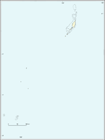
Geographische Lage 7° 11′ N, 134° 16′ O7.1775134.265833333337Koordinaten: 7° 11′ N, 134° 16′ O
Ngerukeuid-Inseln (Palau)
DEC
Ngerukeuid-Inseln

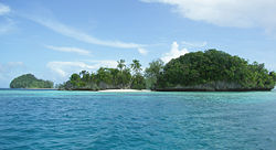
Die Ngerukeuid-Inseln, auch als Seventy Islands bekannt, sind eine unbewohnte Inselgruppe der pazifischen Inselrepublik Palau. Sie liegen im Südwesten des Archipels der Chelbacheb-Inseln (Rock Islands).

Es handelt sich um etwa 40 kleine, flache und dicht bewaldete Inseln. Diese werden heute vielfach von Tauchtouristen von den größeren Inseln Koror, Peleliu oder Ngercheu aus angefahren.

Weblinks


Wikimedia Foundation.

Игры ⚽ Поможем написать реферат

Schlagen Sie auch in anderen Wörterbüchern nach:

  • Seventy (Latter Day Saints) — Seventy is a priesthood office in the Melchizedek priesthood of several denominations within the Latter Day Saint movement, including The Church of Jesus Christ of Latter day Saints (LDS Church). Traditionally, a Latter Day Saint holding this… …   Wikipedia

  • Rock Islands — Chelbacheb Inseln (Rock Islands von Palau) Gewässer Pazifischer Ozean Anzahl der Inseln über 200 …   Deutsch Wikipedia

  • Rock Islands (Palau) — Chelbacheb Inseln (Rock Islands von Palau) Gewässer Pazifischer Ozean Anzahl der Inseln über 200 …   Deutsch Wikipedia

  • Rock Islands von Palau — Chelbacheb Inseln (Rock Islands von Palau) Gewässer Pazifischer Ozean Anzahl der Inseln über 200 …   Deutsch Wikipedia

  • Mentawai Islands Regency — Kepulauan Mentawai   Regency   …   Wikipedia

  • Mentawai Islands — Infobox Regency of Indonesia official name = Kepulauan Mentawai native name = Mentawai Islands province = West Sumatra motto = image mapsize = map caption = capital = Tua Pejat leader name = area magnitude = area total = 6011.35 TotalArea sq mi …   Wikipedia

  • Shetland, or Zetland, Islands —    SHETLAND, or ZETLAND, ISLANDS, forming, with Orkney, a maritime county, in the northern extremity of Scotland, bounded on the north by the North Sea, on the east by the German Ocean, and on the west by the Atlantic. They lie between 59° 51 and …   A Topographical dictionary of Scotland

  • Cocos (Keeling) Islands — Cocos Islands redirects here. It is not to be confused with Cocos Island or Coco Islands. Territory of the Cocos (Keeling) Islands …   Wikipedia

  • Outline of the Northern Mariana Islands — …   Wikipedia

  • Northwestern Hawaiian Islands — …   Wikipedia

Share the article and excerpts

Direct link
Do a right-click on the link above
and select “Copy Link”