- Shipley (West Yorkshire)
-
Shipley Koordinaten 53° 50′ N, 1° 47′ W53.833-1.777Koordinaten: 53° 50′ N, 1° 47′ W 

Shipley Bevölkerung 28.162 (Stand: 2001) Verwaltung Post town SHIPLEY Postleitzahlenabschnitt BD 17,18 Vorwahl 01274 Landesteil England Region Yorkshire and the Humber Shire county West Yorkshire District City of Bradford Britisches Parlament Shipley Shipley ist eine Mittelstadt im Metropolitan Borough City of Bradford der englischen Grafschaft West Yorkshire. Sie besaß 2001 gemäß Volkszählung insgesamt 28.162 Einwohner.
Inhaltsverzeichnis
Geografie
Die Stadt liegt am Fluss Aire und dem Leeds and Liverpool Canal, direkt nördlich von Bradford und nord-westlich von Leeds. Die Stadt liegt innerhalb des Metropolitan Borough of Bradford. Bis 1974 formte es einen eigenen urban district, heute bildet sie mit Bradford einen einheitlichen großstädtischen Bereich.
Sehenswürdigkeiten
 Saltaire
Im Norden von Shipley, auf der anderen Flussseite des Aire, liegt ein bewaldeter Bergrücken, der Shipley Glen. Er gilt seit langer Zeit als besonders schöner Aussichtspunkt und 1895 wurde die Shipley Glen Tramway gebaut, um Besucher auf die Bergspitze zu bringen. Der Tramway läuft an den meisten Wochenenden und wird von Ehrenamtlichen betrieben, gelegentlich wird der Betrieb jedoch wegen schlechten Wetters unterbrochen.
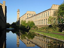
Shipley weist mit dem Dorf Saltaire ein UNESCO-Welterbe auf, das in der Victorianischen Ära entworfen und gebaut wurde, um die Arbeiter des industriellen Tuchfabrikanten Titus Salt unterzubringen. Salt baute seine Fabrik (Salts Mill) direkt am Leeds und Liverpool Canal und beteiligte sich an der Produktion von Alpaka- und Wollstoffen. Salts Mill wird heute genutzt für die 1853 Gallery (Galerie), welche dem Werk von David Hockney gewidmet ist. Außerdem beinhaltet sie einige Geschäfte, Restaurants und Büros.
Verkehr
Ein Bahnanschluss ist über den Bahnhof Shipley an der Airedale Line der Bahnstrecke Leeds-Morecambe gegeben.
Persönlichkeiten
- Arthur Crabtree (1900–1975), Kameramann und Filmregisseur
- Tony Richardson (1928–1991), Regisseur, Drehbuchautor und Produzent
Weblinks
- Salts Mill Official Website
- Shipley College Website
- ourShipley.com Shipley's Community Website


Wikimedia Foundation.